Balveren elevation
Balveren (Şırnak), Turkey elevation is 1301 meters and Balveren elevation in feet is 4268 ft above sea level [src 1]. Balveren is a populated place (feature code) with elevation that is 578 meters (1896 ft) bigger than average city elevation in Turkey.
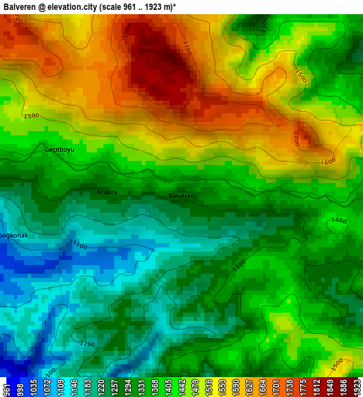
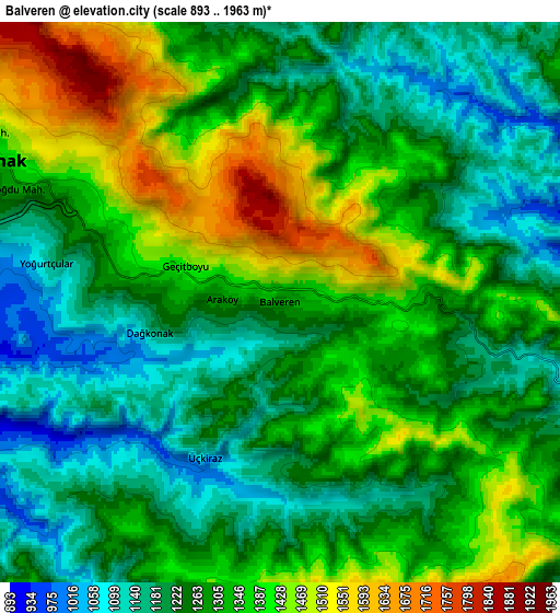
Below is the Elevation map of Balveren, which displays elevation range with different colors. Scale of the first map is from 961 to 1923 m (3153 to 6309 ft) with average elevation of 1391.5 meters (=4565 ft) [note 1]
These maps also provides idea of topography and contour of this city, they are displayed at different zoom levels. More info about maps, scale and edge coordinates you can find below images.
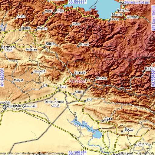
| \ | Map #1 | Map #2 | Topo.Map |
| Scale [m] | 961..1923 m | 893..1963 m | × |
| Scale [ft] | 3153..6309 ft | 2930..6440 ft | × |
| Average | 1391.5 m = 4565 ft | 1296.9 m = 4255 ft | × |
| Width | 7.75 km = 4.8 mi | 15.51 km = 9.6 mi | 248.1 km = 154.2 mi |
| Height | 7.75 km = 4.8 mi | 15.51 km = 9.6 mi | 248.1 km = 154.2 mi |
| ↑Max Latitude | 37.518434° | 37.553281° | 38.59111° |
| Latitude at center | 37.48357° | 37.48357° | 37.48357° |
| ↓Min Latitude | 37.44869° | 37.413794° | 36.35937° |
| ← Min Longitude | 42.504395° | 42.460449° | 41.14209° |
| Longitude center | 42.54834° | 42.54834° | 42.54834° |
| →Max Longitude | 42.592285° | 42.636231° | 43.95459° |
Nearby cities:
Cities around Balveren sort by population:
• Silopi elevation 492 m
27.7 km,  195°
195°
• Şırnak 1269 m
9 km,  292°
292°
• Uludere 1346 m
27.3 km,  100°
100°
• Kumçatı 514 m
23.1 km,  265°
265°
• Şenoba 902 m
15.5 km, 97°
• Çalışkan 694 m
22.3 km,  158°
158°
• Bisbin 889 m
16.2 km,  173°
173°
• Hilal 1032 m
21 km,  92°
92°
• Bağlıca 825 m
20.7 km,  105°
105°
• Çardaklı 649 m
28.3 km, 173°
• Yeniköy 518 m
26.1 km, 204°
• Ballı 1144 m
26.9 km, 106°
Multilingual:
 En español:
Balveren elevación 1301 m.
 En France:
Balveren élévation 1301 m.
 Auf Deutsch:
Balveren höhe über dem Meeresspiegel ist 1301 m.

Sources and notes:
- [note 1] Map square and city borders are not equal. Map elevation data is calculated only from area inside that square.
- [src 1] Elevation data from geonames database provided with same terms of usage.
- [src 2] The elevation map of Balveren is generated using elevation data from NASA's 3 arcsec (90m) resolution SRTM data.
- [src 3] Base (background) map © OpenStreetMap contributors tiles are generated by Geofabrik and OpenTopoMap.
Copyright & License:
This Balveren Elevation Map is licensed under CC BY-SA. You may reuse any part from this page, if you give a proper credit by linking to this URL:
 More info on terms of use page.