Kütahya elevation
Kütahya, Turkey elevation is 947 meters and Kütahya elevation in feet is 3107 ft above sea level [src 1]. Kütahya is a seat of a first-order administrative division (feature code) with elevation that is 224 meters (735 ft) bigger than average city elevation in Turkey.
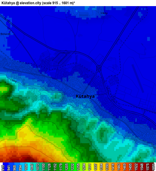
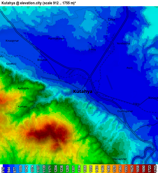
Below is the Elevation map of Kütahya, which displays elevation range with different colors. Scale of the first map is from 915 to 1601 m (3002 to 5253 ft) with average elevation of 1015.7 meters (=3332 ft) [note 1]
These maps also provides idea of topography and contour of this city, they are displayed at different zoom levels. More info about maps, scale and edge coordinates you can find below images.
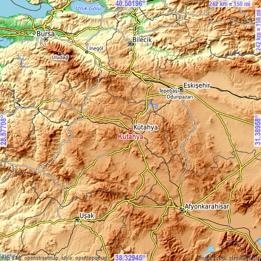
| \ | Map #1 | Map #2 | Topo.Map |
| Scale [m] | 915..1601 m | 912..1755 m | × |
| Scale [ft] | 3002..5253 ft | 2992..5758 ft | × |
| Average | 1015.7 m = 3332 ft | 1090.1 m = 3576 ft | × |
| Width | 7.55 km = 4.7 mi | 15.1 km = 9.4 mi | 241.6 km = 150.1 mi |
| Height | 7.55 km = 4.7 mi | 15.1 km = 9.4 mi | 241.6 km = 150.1 mi |
| ↑Max Latitude | 39.458108° | 39.492029° | 40.50196° |
| Latitude at center | 39.42417° | 39.42417° | 39.42417° |
| ↓Min Latitude | 39.390215° | 39.356244° | 38.32945° |
| ← Min Longitude | 29.939385° | 29.895439° | 28.57708° |
| Longitude center | 29.98333° | 29.98333° | 29.98333° |
| →Max Longitude | 30.027275° | 30.071221° | 31.38958° |
Nearby cities:
Cities around Kütahya sort by population:
• Bozüyük elevation 752 m
54 km,  4°
4°
• Tavşanlı 859 m
43.6 km,  287°
287°
• Domaniç 888 m
52.8 km,  322°
322°
• Kırka 1049 m
49.4 km,  109°
109°
• Dodurga 1098 m
42.1 km,  352°
352°
• Aslanapa 1030 m
25.1 km,  202°
202°
• İnönü 844 m
45.7 km,  17°
17°
• Altıntaş 1033 m
41.9 km,  165°
165°
• Örencik 1036 m
41.8 km,  244°
244°
• Çavdarhisar 1007 m
40.5 km,  230°
230°
• Sabuncu 963 m
23.3 km,  49°
49°
• Köprüören 1023 m
21.2 km,  296°
296°
Multilingual:
 En español:
Kütahya elevación 947 m.
 En France:
Kütahya élévation 947 m.


Sources and notes:
- [note 1] Map square and city borders are not equal. Map elevation data is calculated only from area inside that square.
- [src 1] Elevation data from geonames database provided with same terms of usage.
- [src 2] The elevation map of Kütahya is generated using elevation data from NASA's 3 arcsec (90m) resolution SRTM data.
- [src 3] Base (background) map © OpenStreetMap contributors tiles are generated by Geofabrik and OpenTopoMap.
Copyright & License:
This Kütahya Elevation Map is licensed under CC BY-SA. You may reuse any part from this page, if you give a proper credit by linking to this URL:
 More info on terms of use page.