Örencik elevation
Örencik (Kütahya), Turkey elevation is 1036 meters and Örencik elevation in feet is 3399 ft above sea level [src 1]. Örencik is a seat of a third-order administrative division (feature code) with elevation that is 313 meters (1027 ft) bigger than average city elevation in Turkey.
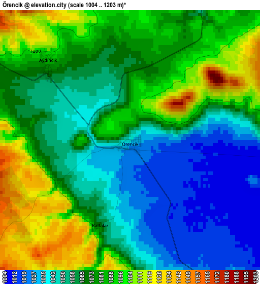
Below is the Elevation map of Örencik, which displays elevation range with different colors. Scale of the first map is from 1004 to 1203 m (3294 to 3947 ft) with average elevation of 1070.3 meters (=3511 ft) [note 1]
These maps also provides idea of topography and contour of this city, they are displayed at different zoom levels. More info about maps, scale and edge coordinates you can find below images.
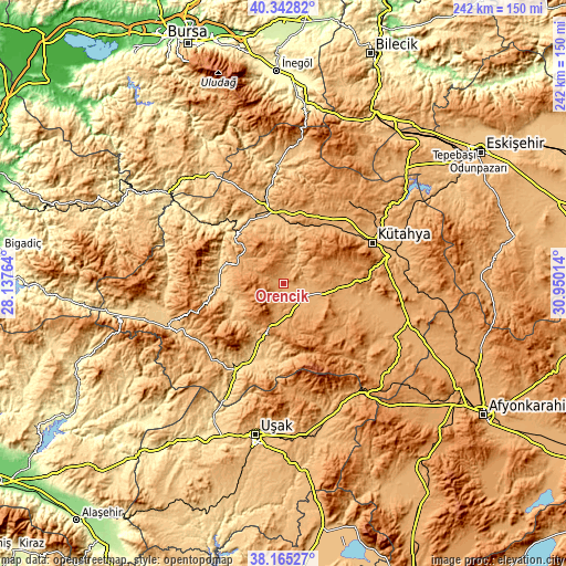
| \ | Map #1 | Topo.Map |
| Scale [m] | 1004..1203 m | × |
| Scale [ft] | 3294..3947 ft | × |
| Average | 1070.3 m = 3511 ft | × |
| Width | 7.57 km = 4.7 mi | 242.1 km = 150.4 mi |
| Height | 7.57 km = 4.7 mi | 242.1 km = 150.4 mi |
| ↑Max Latitude | 39.296517° | 40.34282° |
| Latitude at center | 39.2625° | 39.2625° |
| ↓Min Latitude | 39.228467° | 38.16527° |
| ← Min Longitude | 29.499945° | 28.13764° |
| Longitude center | 29.54389° | 29.54389° |
| →Max Longitude | 29.587835° | 30.95014° |
Nearby cities:
Cities around Örencik sort by population:
• Kütahya elevation 947 m
41.8 km,  64°
64°
• Tavşanlı 859 m
31.4 km,  352°
352°
• Simav 826 m
52.5 km,  248°
248°
• Emet 895 m
26.1 km,  290°
290°
• Gediz 750 m
32.6 km,  203°
203°
• Pazarlar 936 m
46.7 km,  230°
230°
• Şaphane 994 m
38.1 km, 226°
• Aslanapa 1030 m
28.6 km,  100°
100°
• Dağardı 987 m
50.7 km, 291°
• Köprüören 1023 m
33.2 km,  34°
34°
• Hisarcık 763 m
27 km,  267°
267°
• Çavdarhisar 1007 m
10 km,  139°
139°
Multilingual:
 En español:
Örencik elevación 1036 m.
 En France:
Örencik élévation 1036 m.
 Auf Deutsch:
Örencik höhe über dem Meeresspiegel ist 1036 m.

Sources and notes:
- [note 1] Map square and city borders are not equal. Map elevation data is calculated only from area inside that square.
- [src 1] Elevation data from geonames database provided with same terms of usage.
- [src 2] The elevation map of Örencik is generated using elevation data from NASA's 3 arcsec (90m) resolution SRTM data.
- [src 3] Base (background) map © OpenStreetMap contributors tiles are generated by Geofabrik and OpenTopoMap.
Copyright & License:
This Örencik Elevation Map is licensed under CC BY-SA. You may reuse any part from this page, if you give a proper credit by linking to this URL:
 More info on terms of use page.