Sultanbeyli elevation
Sultanbeyli (Istanbul), Turkey elevation is 151 meters and Sultanbeyli elevation in feet is 495 ft above sea level [src 1]. Sultanbeyli is a populated place (feature code) with elevation that is 572 meters (1877 ft) smaller than average city elevation in Turkey.
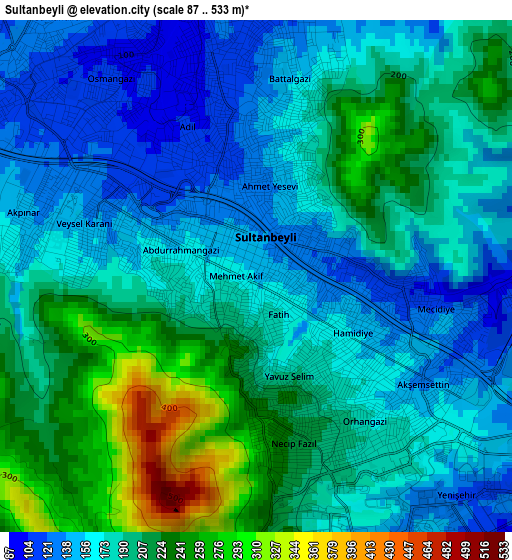
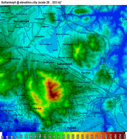
Below is the Elevation map of Sultanbeyli, which displays elevation range with different colors. Scale of the first map is from 87 to 533 m (285 to 1749 ft) with average elevation of 187.5 meters (=615 ft) [note 1]
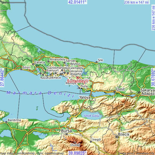
These maps also provides idea of topography and contour of this city, they are displayed at different zoom levels. More info about maps, scale and edge coordinates you can find below images.
| \ | Map #1 | Map #2 | Topo.Map |
| Scale [m] | 87..533 m | 29..533 m | × |
| Scale [ft] | 285..1749 ft | 95..1749 ft | × |
| Average | 187.5 m = 615 ft | 143.6 m = 471 ft | × |
| Width | 7.38 km = 4.6 mi | 14.76 km = 9.2 mi | 236.2 km = 146.8 mi |
| Height | 7.38 km = 4.6 mi | 14.76 km = 9.2 mi | 236.1 km = 146.7 mi |
| ↑Max Latitude | 40.993897° | 41.027058° | 42.01411° |
| Latitude at center | 40.96072° | 40.96072° | 40.96072° |
| ↓Min Latitude | 40.927526° | 40.894315° | 39.89025° |
| ← Min Longitude | 29.226725° | 29.182779° | 27.86442° |
| Longitude center | 29.27067° | 29.27067° | 29.27067° |
| →Max Longitude | 29.314615° | 29.358561° | 30.67692° |
Nearby cities:
Cities around Sultanbeyli sort by population:
• Umraniye elevation 136 m
13.7 km,  296°
296°
• Maltepe 150 m
10.1 km,  253°
253°
• Ataşehir 83 m
13.2 km,  280°
280°
• Sancaktepe 114 m
5.7 km,  324°
324°
• Adalar 65 m
15.5 km,  228°
228°
• İçmeler 15 m
13.1 km,  165°
165°
• Balçık 209 m
16.5 km,  126°
126°
• Çayırova 141 m
17.8 km,  142°
142°
• Ümraniye 140 m
16.3 km, 299°
• Çekmeköy 177 m
11.8 km, 319°
• Pendik 53 m
9.3 km,  179°
179°
• Samandıra 118 m
5.7 km, 318°
Multilingual:
 En español:
Sultanbeyli elevación 151 m.
 En France:
Sultanbeyli élévation 151 m.
 Auf Deutsch:
Sultanbeyli höhe über dem Meeresspiegel ist 151 m.

Sources and notes:
- [note 1] Map square and city borders are not equal. Map elevation data is calculated only from area inside that square.
- [src 1] Elevation data from geonames database provided with same terms of usage.
- [src 2] The elevation map of Sultanbeyli is generated using elevation data from NASA's 3 arcsec (90m) resolution SRTM data.
- [src 3] Base (background) map © OpenStreetMap contributors tiles are generated by Geofabrik and OpenTopoMap.
Copyright & License:
This Sultanbeyli Elevation Map is licensed under CC BY-SA. You may reuse any part from this page, if you give a proper credit by linking to this URL:
 More info on terms of use page.