Karabağlar elevation
Karabağlar (İzmir), Turkey elevation is 66 meters and Karabağlar elevation in feet is 217 ft above sea level [src 1]. Karabağlar is a populated place (feature code) with elevation that is 657 meters (2156 ft) smaller than average city elevation in Turkey.
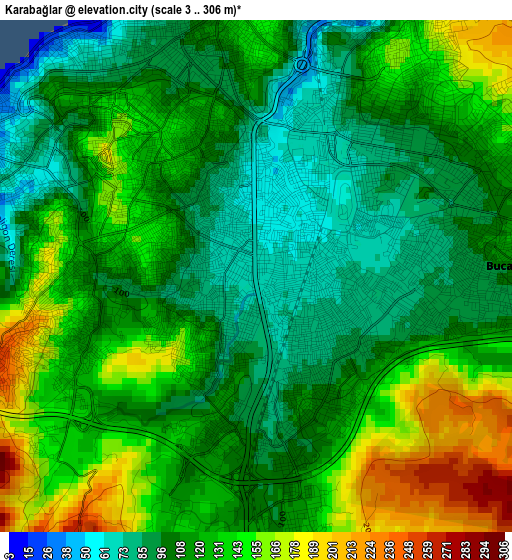
Below is the Elevation map of Karabağlar, which displays elevation range with different colors. Scale of the first map is from 3 to 306 m (10 to 1004 ft) with average elevation of 120.6 meters (=396 ft) [note 1]
These maps also provides idea of topography and contour of this city, they are displayed at different zoom levels. More info about maps, scale and edge coordinates you can find below images.
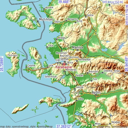
| \ | Map #1 | Map #2 | Topo.Map |
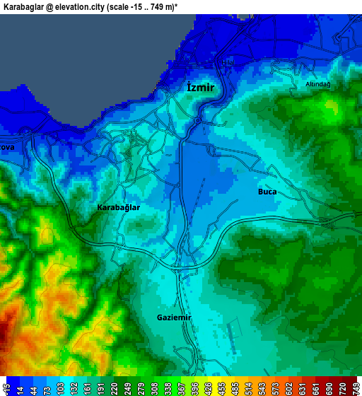
| Scale [m] | 3..306 m | -15..749 m | × |
| Scale [ft] | 10..1004 ft | -49..2457 ft | × |
| Average | 120.6 m = 396 ft | 178 m = 584 ft | × |
| Width | 7.66 km = 4.8 mi | 15.32 km = 9.5 mi | 245.2 km = 152.4 mi |
| Height | 7.66 km = 4.8 mi | 15.32 km = 9.5 mi | 245.2 km = 152.4 mi |
| ↑Max Latitude | 38.408404° | 38.442831° | 39.468° |
| Latitude at center | 38.37396° | 38.37396° | 38.37396° |
| ↓Min Latitude | 38.3395° | 38.305023° | 37.26312° |
| ← Min Longitude | 27.091255° | 27.047309° | 25.72895° |
| Longitude center | 27.1352° | 27.1352° | 27.1352° |
| →Max Longitude | 27.179145° | 27.223091° | 28.54145° |
Nearby cities:
Cities around Karabağlar sort by population:
• İzmir elevation 122 m
4.3 km,  3°
3°
• Menemen 17 m
26.6 km,  347°
347°
• Kemalpaşa 211 m
25.3 km,  76°
76°
• Menderes 118 m
13.8 km,  180°
180°
• Değirmendere 152 m
29 km, 178°
• Emiralem 59 m
26.2 km, 2°
• Dağkızılca 264 m
23.4 km,  107°
107°
• Bornova 125 m
14.8 km,  37°
37°
• Bayraklı 21 m
10.7 km,  13°
13°
• Karşıyaka 10 m
9.5 km, 346°
• Gaziemir 144 m
5.6 km,  185°
185°
• Buca 140 m
3.9 km,  45°
45°
Multilingual:
 En español:
Karabağlar elevación 66 m.
 En France:
Karabağlar élévation 66 m.
 Auf Deutsch:
Karabağlar höhe über dem Meeresspiegel ist 66 m.

Sources and notes:
- [note 1] Map square and city borders are not equal. Map elevation data is calculated only from area inside that square.
- [src 1] Elevation data from geonames database provided with same terms of usage.
- [src 2] The elevation map of Karabağlar is generated using elevation data from NASA's 3 arcsec (90m) resolution SRTM data.
- [src 3] Base (background) map © OpenStreetMap contributors tiles are generated by Geofabrik and OpenTopoMap.
Copyright & License:
This Karabağlar Elevation Map is licensed under CC BY-SA. You may reuse any part from this page, if you give a proper credit by linking to this URL:
 More info on terms of use page.