Giresun elevation
Giresun, Turkey elevation is 39 meters and Giresun elevation in feet is 128 ft above sea level [src 1]. Giresun is a seat of a first-order administrative division (feature code) with elevation that is 684 meters (2244 ft) smaller than average city elevation in Turkey.
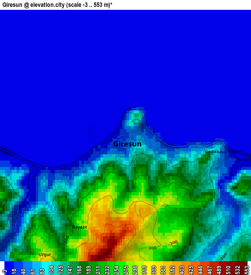
Below is the Elevation map of Giresun, which displays elevation range with different colors. Scale of the first map is from -3 to 553 m (-10 to 1814 ft) with average elevation of 79.3 meters (=260 ft) [note 1]
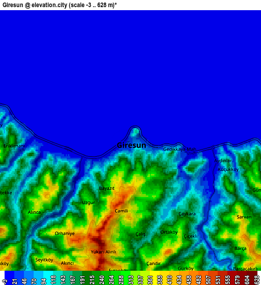
These maps also provides idea of topography and contour of this city, they are displayed at different zoom levels. More info about maps, scale and edge coordinates you can find below images.
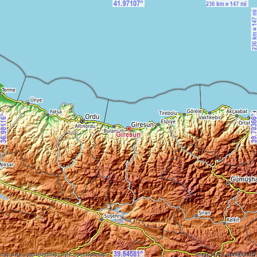
| \ | Map #1 | Map #2 | Topo.Map |
| Scale [m] | -3..553 m | -3..628 m | × |
| Scale [ft] | -10..1814 ft | -10..2060 ft | × |
| Average | 79.3 m = 260 ft | 104.1 m = 342 ft | × |
| Width | 7.38 km = 4.6 mi | 14.77 km = 9.2 mi | 236.3 km = 146.8 mi |
| Height | 7.38 km = 4.6 mi | 14.77 km = 9.2 mi | 236.3 km = 146.8 mi |
| ↑Max Latitude | 40.950179° | 40.983362° | 41.97107° |
| Latitude at center | 40.91698° | 40.91698° | 40.91698° |
| ↓Min Latitude | 40.883764° | 40.850531° | 39.84581° |
| ← Min Longitude | 38.343465° | 38.299519° | 36.98116° |
| Longitude center | 38.38741° | 38.38741° | 38.38741° |
| →Max Longitude | 38.431355° | 38.475301° | 39.79366° |
Nearby cities:
Cities around Giresun sort by population:
• Bulancak elevation 12 m
13.3 km,  280°
280°
• Espiye 13 m
26.7 km,  82°
82°
• Keşap 177 m
9.6 km,  94°
94°
• Piraziz 321 m
22.1 km,  271°
271°
• Dereli 550 m
20.4 km,  166°
166°
• Güce 250 m
34.6 km, 94°
• Kovanlık 969 m
29.4 km,  232°
232°
• Gülyalı 123 m
28.8 km, 279°
• Yavuzkemal 1663 m
25.2 km,  189°
189°
• Piraziz 100 m
23.7 km, 279°
• Yağlıdere 361 m
20.7 km,  108°
108°
• Karabulduk 338 m
17.3 km,  128°
128°
Multilingual:
 En español:
Giresun elevación 39 m.
 En France:
Giresun élévation 39 m.


Sources and notes:
- [note 1] Map square and city borders are not equal. Map elevation data is calculated only from area inside that square.
- [src 1] Elevation data from geonames database provided with same terms of usage.
- [src 2] The elevation map of Giresun is generated using elevation data from NASA's 3 arcsec (90m) resolution SRTM data.
- [src 3] Base (background) map © OpenStreetMap contributors tiles are generated by Geofabrik and OpenTopoMap.
Copyright & License:
This Giresun Elevation Map is licensed under CC BY-SA. You may reuse any part from this page, if you give a proper credit by linking to this URL:
 More info on terms of use page.