Balıkesir elevation
Balıkesir, Turkey elevation is 139 meters and Balıkesir elevation in feet is 456 ft above sea level [src 1]. Balıkesir is a seat of a first-order administrative division (feature code) with elevation that is 584 meters (1916 ft) smaller than average city elevation in Turkey.
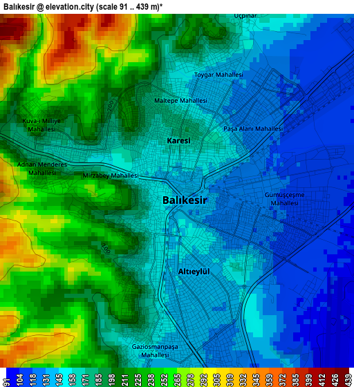
Below is the Elevation map of Balıkesir, which displays elevation range with different colors. Scale of the first map is from 91 to 439 m (299 to 1440 ft) with average elevation of 179.6 meters (=589 ft) [note 1]
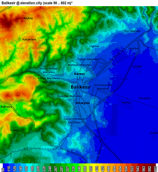
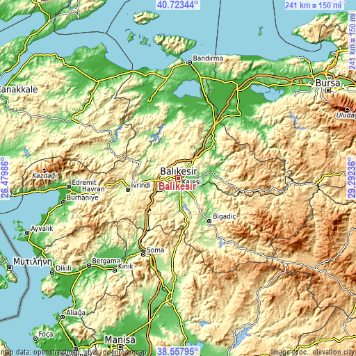
These maps also provides idea of topography and contour of this city, they are displayed at different zoom levels. More info about maps, scale and edge coordinates you can find below images.
| \ | Map #1 | Map #2 | Topo.Map |
| Scale [m] | 91..439 m | 90..602 m | × |
| Scale [ft] | 299..1440 ft | 295..1975 ft | × |
| Average | 179.6 m = 589 ft | 222.6 m = 730 ft | × |
| Width | 7.52 km = 4.7 mi | 15.05 km = 9.4 mi | 240.8 km = 149.6 mi |
| Height | 7.52 km = 4.7 mi | 15.05 km = 9.4 mi | 240.8 km = 149.6 mi |
| ↑Max Latitude | 39.682998° | 39.71681° | 40.72344° |
| Latitude at center | 39.64917° | 39.64917° | 39.64917° |
| ↓Min Latitude | 39.615325° | 39.581464° | 38.55795° |
| ← Min Longitude | 27.842165° | 27.798219° | 26.47986° |
| Longitude center | 27.88611° | 27.88611° | 27.88611° |
| →Max Longitude | 27.930055° | 27.974001° | 29.29236° |
Nearby cities:
Cities around Balıkesir sort by population:
• Kepsut elevation 88 m
23.2 km,  79°
79°
• Balya 221 m
28.5 km,  292°
292°
• Durak 528 m
33.6 km, 79°
• Danişment 290 m
32.7 km,  318°
318°
• Ilıca 135 m
26.9 km,  339°
339°
• Ömerköy 118 m
25.4 km,  37°
37°
• Konakpınar 373 m
24.3 km,  190°
190°
• Ergama 183 m
21.9 km,  263°
263°
• Şamlı 334 m
18.4 km,  349°
349°
• Çağış 239 m
18.1 km,  143°
143°
• Yeniköy 243 m
17.5 km,  34°
34°
• Ertuğrul 199 m
17.4 km,  242°
242°
Multilingual:
 En español:
Balikesir elevación 139 m.
 En France:
Balıkesir élévation 139 m.
 Auf Deutsch:
Balıkesir höhe über dem Meeresspiegel ist 139 m.

Sources and notes:
- [note 1] Map square and city borders are not equal. Map elevation data is calculated only from area inside that square.
- [src 1] Elevation data from geonames database provided with same terms of usage.
- [src 2] The elevation map of Balıkesir is generated using elevation data from NASA's 3 arcsec (90m) resolution SRTM data.
- [src 3] Base (background) map © OpenStreetMap contributors tiles are generated by Geofabrik and OpenTopoMap.
Copyright & License:
This Balıkesir Elevation Map is licensed under CC BY-SA. You may reuse any part from this page, if you give a proper credit by linking to this URL:
 More info on terms of use page.