Balya elevation
Balya (Balıkesir), Turkey elevation is 221 meters and Balya elevation in feet is 725 ft above sea level [src 1]. Balya is a seat of a second-order administrative division (feature code) with elevation that is 502 meters (1647 ft) smaller than average city elevation in Turkey.
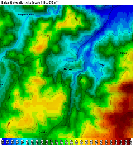
Below is the Elevation map of Balya, which displays elevation range with different colors. Scale of the first map is from 119 to 635 m (390 to 2083 ft) with average elevation of 327 meters (=1073 ft) [note 1]
These maps also provides idea of topography and contour of this city, they are displayed at different zoom levels. More info about maps, scale and edge coordinates you can find below images.
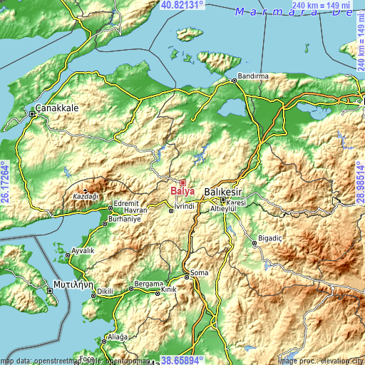
| \ | Map #1 | Topo.Map |
| Scale [m] | 119..635 m | × |
| Scale [ft] | 390..2083 ft | × |
| Average | 327 m = 1073 ft | × |
| Width | 7.51 km = 4.7 mi | 240.4 km = 149.4 mi |
| Height | 7.51 km = 4.7 mi | 240.4 km = 149.4 mi |
| ↑Max Latitude | 39.782389° | 40.82131° |
| Latitude at center | 39.74861° | 39.74861° |
| ↓Min Latitude | 39.714814° | 38.65894° |
| ← Min Longitude | 27.534945° | 26.17264° |
| Longitude center | 27.57889° | 27.57889° |
| →Max Longitude | 27.622835° | 28.98514° |
Nearby cities:
Cities around Balya sort by population:
• Balıkesir elevation 139 m
28.5 km,  112°
112°
• İvrindi 259 m
20 km,  203°
203°
• Kalkım 232 m
31.9 km,  282°
282°
• Hamdibey 247 m
30.4 km,  291°
291°
• Yenice 274 m
34.1 km,  306°
306°
• Kayapa 310 m
30.7 km, 201°
• Şamlı 334 m
23.8 km,  72°
72°
• Ertuğrul 199 m
22.1 km,  150°
150°
• Ilıca 135 m
22 km,  50°
50°
• Pazarköy 180 m
19 km, 307°
• Ergama 183 m
14.2 km,  161°
161°
• Danişment 290 m
14.2 km,  19°
19°
Multilingual:
 En español:
Balya elevación 221 m.
 En France:
Balya élévation 221 m.


Sources and notes:
- [note 1] Map square and city borders are not equal. Map elevation data is calculated only from area inside that square.
- [src 1] Elevation data from geonames database provided with same terms of usage.
- [src 2] The elevation map of Balya is generated using elevation data from NASA's 3 arcsec (90m) resolution SRTM data.
- [src 3] Base (background) map © OpenStreetMap contributors tiles are generated by Geofabrik and OpenTopoMap.
Copyright & License:
This Balya Elevation Map is licensed under CC BY-SA. You may reuse any part from this page, if you give a proper credit by linking to this URL:
 More info on terms of use page.