Hamdibey elevation
Hamdibey (Canakkale), Turkey elevation is 247 meters and Hamdibey elevation in feet is 810 ft above sea level [src 1]. Hamdibey is a seat of a third-order administrative division (feature code) with elevation that is 476 meters (1562 ft) smaller than average city elevation in Turkey.
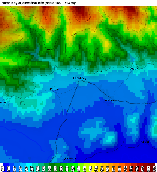
Below is the Elevation map of Hamdibey, which displays elevation range with different colors. Scale of the first map is from 186 to 713 m (610 to 2339 ft) with average elevation of 322.5 meters (=1058 ft) [note 1]
These maps also provides idea of topography and contour of this city, they are displayed at different zoom levels. More info about maps, scale and edge coordinates you can find below images.
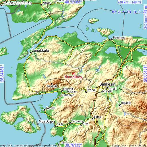
| \ | Map #1 | Topo.Map |
| Scale [m] | 186..713 m | × |
| Scale [ft] | 610..2339 ft | × |
| Average | 322.5 m = 1058 ft | × |
| Width | 7.5 km = 4.7 mi | 240.1 km = 149.2 mi |
| Height | 7.5 km = 4.7 mi | 240.1 km = 149.2 mi |
| ↑Max Latitude | 39.88317° | 40.92055° |
| Latitude at center | 39.84944° | 39.84944° |
| ↓Min Latitude | 39.815694° | 38.76135° |
| ← Min Longitude | 27.204115° | 25.84181° |
| Longitude center | 27.24806° | 27.24806° |
| →Max Longitude | 27.292005° | 28.65431° |
Nearby cities:
Cities around Hamdibey sort by population:
• Edremit elevation 30 m
34 km,  214°
214°
• Çan 115 m
26.4 km,  320°
320°
• Havran 42 m
34.8 km,  201°
201°
• İvrindi 259 m
35.9 km,  145°
145°
• Kalkım 232 m
5.1 km, 213°
• Balya 221 m
30.4 km,  111°
111°
• Evciler 242 m
41.5 km,  258°
258°
• Ergama 183 m
41.1 km,  127°
127°
• Etili 130 m
33.6 km,  296°
296°
• Danişment 290 m
32.9 km,  86°
86°
• Pazarköy 180 m
13.2 km, 88°
• Yenice 274 m
9.1 km,  5°
5°
Multilingual:
 En español:
Hamdibey elevación 247 m.
 En France:
Hamdibey élévation 247 m.
 Auf Deutsch:
Hamdibey höhe über dem Meeresspiegel ist 247 m.

Sources and notes:
- [note 1] Map square and city borders are not equal. Map elevation data is calculated only from area inside that square.
- [src 1] Elevation data from geonames database provided with same terms of usage.
- [src 2] The elevation map of Hamdibey is generated using elevation data from NASA's 3 arcsec (90m) resolution SRTM data.
- [src 3] Base (background) map © OpenStreetMap contributors tiles are generated by Geofabrik and OpenTopoMap.
Copyright & License:
This Hamdibey Elevation Map is licensed under CC BY-SA. You may reuse any part from this page, if you give a proper credit by linking to this URL:
 More info on terms of use page.