Batikent elevation
Batikent (Ankara), Turkey elevation is 862 meters and Batikent elevation in feet is 2828 ft above sea level [src 1]. Batikent is a section of populated place (feature code) with elevation that is 139 meters (456 ft) bigger than average city elevation in Turkey.
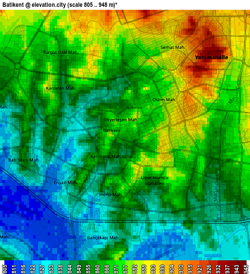
Below is the Elevation map of Batikent, which displays elevation range with different colors. Scale of the first map is from 805 to 948 m (2641 to 3110 ft) with average elevation of 859.1 meters (=2819 ft) [note 1]
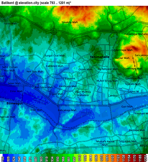
These maps also provides idea of topography and contour of this city, they are displayed at different zoom levels. More info about maps, scale and edge coordinates you can find below images.
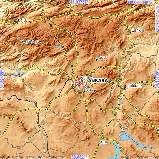
| \ | Map #1 | Map #2 | Topo.Map |
| Scale [m] | 805..948 m | 793..1201 m | × |
| Scale [ft] | 2641..3110 ft | 2602..3940 ft | × |
| Average | 859.1 m = 2819 ft | 894 m = 2933 ft | × |
| Width | 7.49 km = 4.7 mi | 14.98 km = 9.3 mi | 239.7 km = 148.9 mi |
| Height | 7.49 km = 4.7 mi | 14.98 km = 9.3 mi | 239.7 km = 148.9 mi |
| ↑Max Latitude | 40.002001° | 40.035656° | 41.03757° |
| Latitude at center | 39.96833° | 39.96833° | 39.96833° |
| ↓Min Latitude | 39.934642° | 39.900937° | 38.8821° |
| ← Min Longitude | 32.686885° | 32.642939° | 31.32458° |
| Longitude center | 32.73083° | 32.73083° | 32.73083° |
| →Max Longitude | 32.774775° | 32.818721° | 34.13708° |
Nearby cities:
Cities around Batikent sort by population:
• Ankara elevation 874 m
11.8 km,  117°
117°
• Çankaya 889 m
12.6 km, 116°
• Çubuk 999 m
39.5 km,  40°
40°
• Kazan 928 m
29.6 km,  352°
352°
• Akyurt 1041 m
35.5 km,  58°
58°
• Ayaş 953 m
34.4 km,  279°
279°
• Temelli 768 m
41.8 km,  230°
230°
• Pazar 1032 m
40.3 km,  2°
2°
• Gölbaşı 990 m
20.9 km,  161°
161°
• Pursaklar 1061 m
15.7 km, 63°
• Mamak 945 m
15.6 km,  101°
101°
• Etimesgut 805 m
8.5 km,  258°
258°
Multilingual:
 En español:
Batikent elevación 862 m.
 En France:
Batikent élévation 862 m.
 Auf Deutsch:
Batikent höhe über dem Meeresspiegel ist 862 m.

Sources and notes:
- [note 1] Map square and city borders are not equal. Map elevation data is calculated only from area inside that square.
- [src 1] Elevation data from geonames database provided with same terms of usage.
- [src 2] The elevation map of Batikent is generated using elevation data from NASA's 3 arcsec (90m) resolution SRTM data.
- [src 3] Base (background) map © OpenStreetMap contributors tiles are generated by Geofabrik and OpenTopoMap.
Copyright & License:
This Batikent Elevation Map is licensed under CC BY-SA. You may reuse any part from this page, if you give a proper credit by linking to this URL:
 More info on terms of use page.