Uganda elevation
On our site we have elevation data and maps for 142 cities from Uganda including Kampala as capital of the country.
Uganda on topographic map
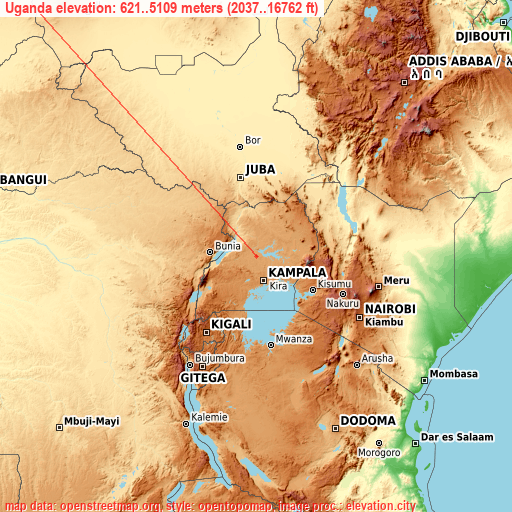
Uganda elevation extremes
Land surface elevation extremes in Uganda:
- Highest point in Uganda: Mount Stanley (Margherita Peak) with 5109 meters (=16762 ft)
- Lowest point: Albert Nile with 621 meters (=2037 ft)
- Elevation span: 4488 m (=14724 ft)
Statistics
- Main average elevation: 1201 meters (= 3940 ft)
- Average elevation of cities: 1259 m (= 4131 ft), and this is 863 m (2831 ft) above average city elevation worldwide..[1]
- Area: 236,040 km² (= 91,136 sq mi)
- Population: 33,398,682


List of cities in ABC order:
Search by letter:
A B D E F G H I J K L M N O P R S T W Y Z
A:
Abim Adjumani Agago Alebtong Amolatar Amudat Amuria Amuru Apac Arua
B:
Binyin Budaka Bududa Bugembe Bugiri Buhweju Buikwe Bukedea Bukomansimbi Bukwa Bulambuli Bulisa Bundibugyo Busembatia Bushenyi Busia Butaleja Butebo Buwenge Buyende Bweyogerere Bwizibwera Byakabanda
D:
Dokolo
E:
Entebbe
F:
Fort Portal
G:
Gombe Gulu
H:
Hoima
I:
Ibanda Iganga Isingiro
J:
Jinja
K:
Kaabong Kabale Kaberamaido Kagadi Kajansi Kakumiro Kalangala Kaliro Kalungu Kampala Kampala Central Division Kamuli Kamwenge Kanoni Kanungu Kapchorwa Kasaali Kasese Katakwi Kayunga Kibale Kibingo Kiboga Kibuku Kigorobya Kilembe Kireka Kiruhura Kiryandongo Kisoro Kitamilo Kitgum Koboko Kole Kotido Kumi Kyankwanzi Kyegegwa Kyenjojo Kyotera
L:
Lamwo Lira Lugazi Luuka Town Luwero Lwengo Lyantonde
M:
Manafwa Maracha Margherita Masaka Masindi Masindi Port Mayuge Mbale Mbarara Mitoma Mityana Moroto Moyo Mpigi Mubende Muhororo Mukono
N:
Nakapiripirit Nakaseke Nakasongola Namasuba Namayingo Namutumba Napak Nebbi Ngora Njeru Nsika Ntoroko Ntungamo Ntungamo Nwoya Nyachera
O:
Otuke Oyam
P:
Pader Pader Palwo Paidha Pallisa
R:
Rakai Rubanda Rubirizi Rukungiri
S:
Sembabule Serere Sironko Soroti
T:
Tororo
W:
Wakiso Wobulenzi
Y:
Yumbe
Z:
Zombo
15 most populated cities are in red/bold font style.

A:
Abim Adjumani Agago Alebtong Amolatar Amudat Amuria Amuru Apac Arua
B:
Binyin Budaka Bududa Bugembe Bugiri Buhweju Buikwe Bukedea Bukomansimbi Bukwa Bulambuli Bulisa Bundibugyo Busembatia Bushenyi Busia Butaleja Butebo Buwenge Buyende Bweyogerere Bwizibwera Byakabanda
D:
Dokolo
E:
Entebbe
F:
Fort Portal
G:
Gombe Gulu
H:
Hoima
I:
Ibanda Iganga Isingiro
J:
Jinja
K:
Kaabong Kabale Kaberamaido Kagadi Kajansi Kakumiro Kalangala Kaliro Kalungu Kampala Kampala Central Division Kamuli Kamwenge Kanoni Kanungu Kapchorwa Kasaali Kasese Katakwi Kayunga Kibale Kibingo Kiboga Kibuku Kigorobya Kilembe Kireka Kiruhura Kiryandongo Kisoro Kitamilo Kitgum Koboko Kole Kotido Kumi Kyankwanzi Kyegegwa Kyenjojo Kyotera
L:
Lamwo Lira Lugazi Luuka Town Luwero Lwengo Lyantonde
M:
Manafwa Maracha Margherita Masaka Masindi Masindi Port Mayuge Mbale Mbarara Mitoma Mityana Moroto Moyo Mpigi Mubende Muhororo Mukono
N:
Nakapiripirit Nakaseke Nakasongola Namasuba Namayingo Namutumba Napak Nebbi Ngora Njeru Nsika Ntoroko Ntungamo Ntungamo Nwoya Nyachera
O:
Otuke Oyam
P:
Pader Pader Palwo Paidha Pallisa
R:
Rakai Rubanda Rubirizi Rukungiri
S:
Sembabule Serere Sironko Soroti
T:
Tororo
W:
Wakiso Wobulenzi
Y:
Yumbe
Z:
Zombo
Sources
- Elevation extremes by country from wikipedia.
- Base map data: © OpenStreetMap contributors, | map style: © OpenTopoMap (CC-BY-SA)
- [1] Calculated only from 142 cities in our database
- Other city data from geonames.org with taken over terms of usage.
- Min/max latitude and longitude coordinates per country from latitudelongitude.org website.