Democratic Republic of the Congo elevation
On our site we have elevation data and maps for 71 cities from Democratic Republic of the Congo including Kinshasa as capital of the country.
Democratic Republic of the Congo on topographic map
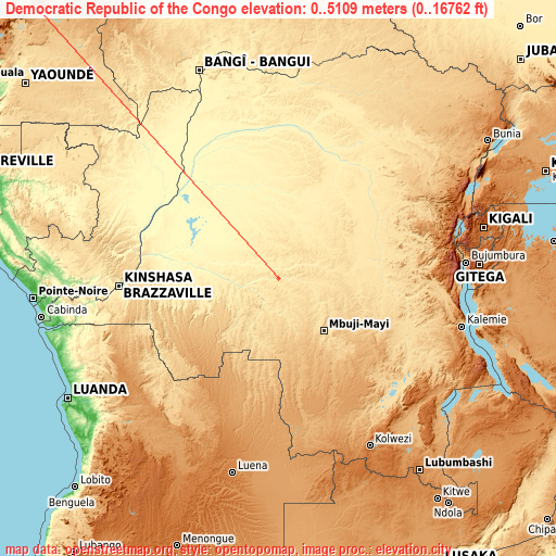
Democratic Republic of the Congo elevation extremes
Land surface elevation extremes in Democratic Republic of the Congo:
- Highest point in Democratic Republic of the Congo: Mount Stanley (Margherita Peak) with 5109 meters (=16762 ft)
- Lowest point: South Atlantic Ocean with 0 meters (=0 ft)
- Elevation span: 5109 m (=16762 ft)
Statistics
- Average elevation of cities: 656 m (= 2152 ft), and this is 260 m (853 ft) above average city elevation worldwide..[1]
- Area: 2,345,410 km² (= 905,568 sq mi)
- Population: 70,916,439
Neighbour countries: Tanzania  Central African Republic
  South Sudan
  Rwanda
  Zambia
  Burundi
  Uganda
  Republic of the Congo
  Angola
Central African Republic South Sudan Rwanda Zambia Burundi Uganda Republic of the Congo Angola List of cities in ABC order:
Search by letter:
A B D G I K L M N S T U W Y
A:
Aketi
B:
Bandundu Basoko Beni Boende Bolobo Boma Bondo Bongandanga Bosobolo Bukama Bukavu Bulungu Bumba Bunia Businga Buta Butembo
D:
Demba
G:
Gandajika Gbadolite Gemena Goma
I:
Ilebo Inongo Isiro
K:
Kabalo Kabare Kabinda Kalemie Kambove Kamina Kampene Kananga Kasangulu Kasongo Kasongo-Lunda Kikwit Kindu Kinshasa Kipushi Kisangani Kolwezi Kongolo
L:
Libenge Likasi Lisala Lodja Lubao Lubumbashi Luebo Lukolela Lusambo
M:
Mangai Masina Matadi Mbandaka Mbanza-Ngungu Mbuji-Mayi Moanda Mushie Mweka Mwene-Ditu
N:
Nioki
S:
Sake
T:
Tshela Tshikapa
U:
Uvira
W:
Wamba Watsa
Y:
Yangambi
10 most populated cities are in red/bold font style.

A:
Aketi
B:
Bandundu Basoko Beni Boende Bolobo Boma Bondo Bongandanga Bosobolo Bukama Bukavu Bulungu Bumba Bunia Businga Buta Butembo
D:
Demba
G:
Gandajika Gbadolite Gemena Goma
I:
Ilebo Inongo Isiro
K:
Kabalo Kabare Kabinda Kalemie Kambove Kamina Kampene Kananga Kasangulu Kasongo Kasongo-Lunda Kikwit Kindu Kinshasa Kipushi Kisangani Kolwezi Kongolo
L:
Libenge Likasi Lisala Lodja Lubao Lubumbashi Luebo Lukolela Lusambo
M:
Mangai Masina Matadi Mbandaka Mbanza-Ngungu Mbuji-Mayi Moanda Mushie Mweka Mwene-Ditu
N:
Nioki
S:
Sake
T:
Tshela Tshikapa
U:
Uvira
W:
Wamba Watsa
Y:
Yangambi
Sources
- Elevation extremes by country from wikipedia.
- Base map data: © OpenStreetMap contributors, | map style: © OpenTopoMap (CC-BY-SA)
- [1] Calculated only from 71 cities in our database
- Other city data from geonames.org with taken over terms of usage.
- Min/max latitude and longitude coordinates per country from latitudelongitude.org website.