Pallisa elevation
Pallisa (Eastern Region, Pallisa District), Uganda elevation is 1056 meters and Pallisa elevation in feet is 3465 ft above sea level [src 1]. Pallisa is a seat of a second-order administrative division (feature code) with elevation that is 203 meters (666 ft) smaller than average city elevation in Uganda.
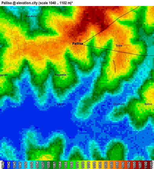
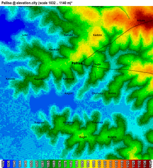
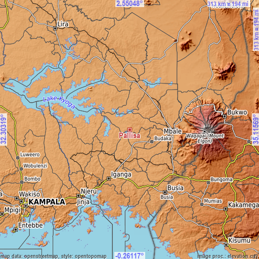
Below is the Elevation map of Pallisa, which displays elevation range with different colors. Scale of the first map is from 1040 to 1102 m (3412 to 3615 ft) with average elevation of 1061.5 meters (=3483 ft) [note 1]
These maps also provides idea of topography and contour of this city, they are displayed at different zoom levels. More info about maps, scale and edge coordinates you can find below images.
| \ | Map #1 | Map #2 | Topo.Map |
| Scale [m] | 1040..1102 m | 1032..1140 m | × |
| Scale [ft] | 3412..3615 ft | 3386..3740 ft | × |
| Average | 1061.5 m = 3483 ft | 1064.5 m = 3492 ft | × |
| Width | 9.77 km = 6.1 mi | 19.54 km = 12.1 mi | 312.6 km = 194.2 mi |
| Height | 9.77 km = 6.1 mi | 19.54 km = 12.1 mi | 312.7 km = 194.3 mi |
| ↑Max Latitude | 1.188936° | 1.232872° | 2.55048° |
| Latitude at center | 1.145° | 1.145° | 1.145° |
| ↓Min Latitude | 1.101063° | 1.057126° | -0.26117° |
| ← Min Longitude | 33.665495° | 33.621549° | 32.30319° |
| Longitude center | 33.70944° | 33.70944° | 33.70944° |
| →Max Longitude | 33.753385° | 33.797331° | 35.11569° |
Nearby cities:
Cities around Pallisa sort by population:
• Mbale elevation 1125 m
52.2 km,  97°
97°
• Busembatia 1123 m
42 km,  193°
193°
• Kumi 1142 m
43.2 km,  35°
35°
• Serere 1075 m
48 km,  323°
323°
• Bukedea 1124 m
42.5 km,  63°
63°
• Butaleja 1067 m
37.3 km,  133°
133°
• Kaliro 1085 m
36.3 km,  219°
219°
• Namutumba 1138 m
34.4 km,  184°
184°
• Ngora 1103 m
32.7 km,  13°
13°
• Budaka 1112 m
28.7 km,  123°
123°
• Butebo 1128 m
24.3 km,  76°
76°
• Kibuku 1107 m
15 km,  139°
139°
Multilingual:
 En español:
Pallisa elevación 1056 m.
 En France:
Pallisa élévation 1056 m.
 Auf Deutsch:
Pallisa höhe über dem Meeresspiegel ist 1056 m.

Sources and notes:
- [note 1] Map square and city borders are not equal. Map elevation data is calculated only from area inside that square.
- [src 1] Elevation data from geonames database provided with same terms of usage.
- [src 2] The elevation map of Pallisa is generated using elevation data from NASA's 3 arcsec (90m) resolution SRTM data.
- [src 3] Base (background) map © OpenStreetMap contributors tiles are generated by Geofabrik and OpenTopoMap.
Copyright & License:
This Pallisa Elevation Map is licensed under CC BY-SA. You may reuse any part from this page, if you give a proper credit by linking to this URL:
 More info on terms of use page.