Bugembe elevation
Bugembe (Eastern Region, Jinja District), Uganda elevation is 1312 meters and Bugembe elevation in feet is 4304 ft above sea level [src 1]. Bugembe is a populated place (feature code) with elevation that is 53 meters (174 ft) bigger than average city elevation in Uganda.
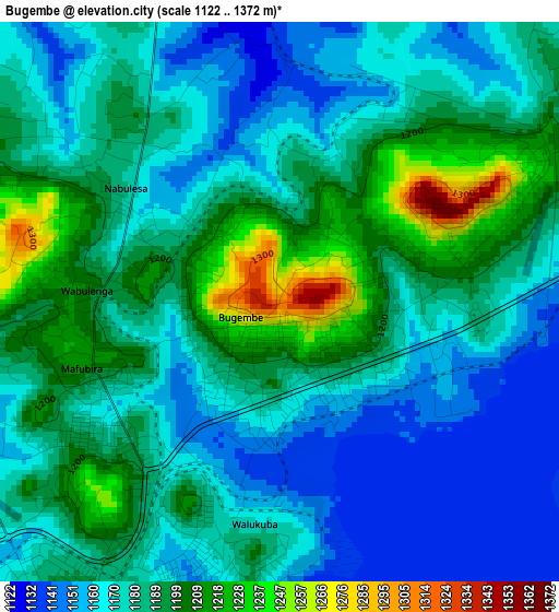
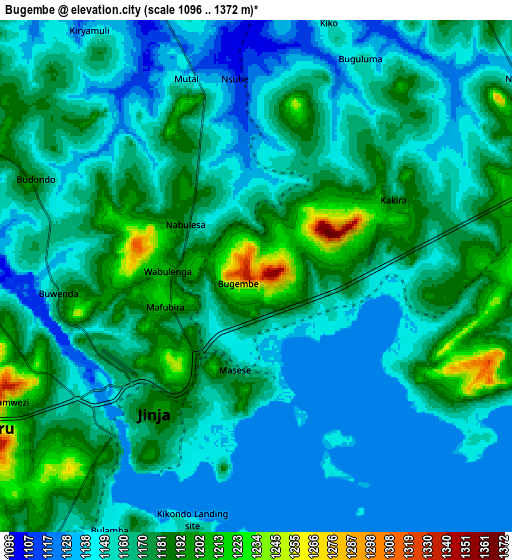
Below is the Elevation map of Bugembe, which displays elevation range with different colors. Scale of the first map is from 1122 to 1372 m (3681 to 4501 ft) with average elevation of 1181.4 meters (=3876 ft) [note 1]
These maps also provides idea of topography and contour of this city, they are displayed at different zoom levels. More info about maps, scale and edge coordinates you can find below images.
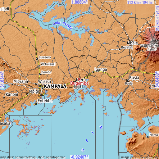
| \ | Map #1 | Map #2 | Topo.Map |
| Scale [m] | 1122..1372 m | 1096..1372 m | × |
| Scale [ft] | 3681..4501 ft | 3596..4501 ft | × |
| Average | 1181.4 m = 3876 ft | 1164 m = 3819 ft | × |
| Width | 9.77 km = 6.1 mi | 19.54 km = 12.1 mi | 312.7 km = 194.3 mi |
| Height | 9.77 km = 6.1 mi | 19.54 km = 12.1 mi | 312.7 km = 194.3 mi |
| ↑Max Latitude | 0.526074° | 0.570017° | 1.88804° |
| Latitude at center | 0.48213° | 0.48213° | 0.48213° |
| ↓Min Latitude | 0.438186° | 0.394242° | -0.92407° |
| ← Min Longitude | 33.196705° | 33.152759° | 31.8344° |
| Longitude center | 33.24065° | 33.24065° | 33.24065° |
| →Max Longitude | 33.284595° | 33.328541° | 34.6469° |
Nearby cities:
Cities around Bugembe sort by population:
• Jinja elevation 1187 m
6.4 km,  221°
221°
• Njeru 1152 m
8.2 km,  236°
236°
• Iganga 1128 m
29 km,  60°
60°
• Lugazi 1208 m
36 km,  249°
249°
• Kayunga 1071 m
46.2 km,  302°
302°
• Busembatia 1123 m
53.8 km,  52°
52°
• Buwenge 1124 m
20.2 km,  337°
337°
• Kamuli 1120 m
53.4 km,  345°
345°
• Mayuge 1192 m
26.8 km,  95°
95°
• Buikwe 1230 m
30.2 km, 237°
• Kitamilo 1134 m
29.2 km,  187°
187°
• Luuka Town 1151 m
25.2 km,  15°
15°
Multilingual:
 En español:
Bugembe elevación 1312 m.
 En France:
Bugembe élévation 1312 m.
 Auf Deutsch:
Bugembe höhe über dem Meeresspiegel ist 1312 m.

Sources and notes:
- [note 1] Map square and city borders are not equal. Map elevation data is calculated only from area inside that square.
- [src 1] Elevation data from geonames database provided with same terms of usage.
- [src 2] The elevation map of Bugembe is generated using elevation data from NASA's 3 arcsec (90m) resolution SRTM data.
- [src 3] Base (background) map © OpenStreetMap contributors tiles are generated by Geofabrik and OpenTopoMap.
Copyright & License:
This Bugembe Elevation Map is licensed under CC BY-SA. You may reuse any part from this page, if you give a proper credit by linking to this URL:
 More info on terms of use page.