Moroto elevation
Moroto (Northern Region, Moroto District), Uganda elevation is 1393 meters and Moroto elevation in feet is 4570 ft above sea level [src 1]. Moroto is a seat of a second-order administrative division (feature code) with elevation that is 134 meters (440 ft) bigger than average city elevation in Uganda.
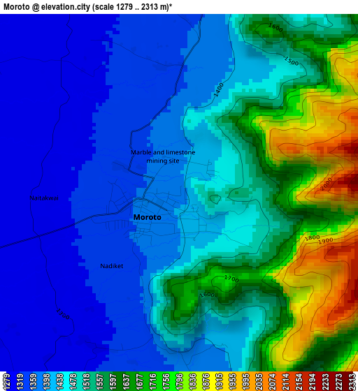
Below is the Elevation map of Moroto, which displays elevation range with different colors. Scale of the first map is from 1279 to 2313 m (4196 to 7589 ft) with average elevation of 1490.1 meters (=4889 ft) [note 1]
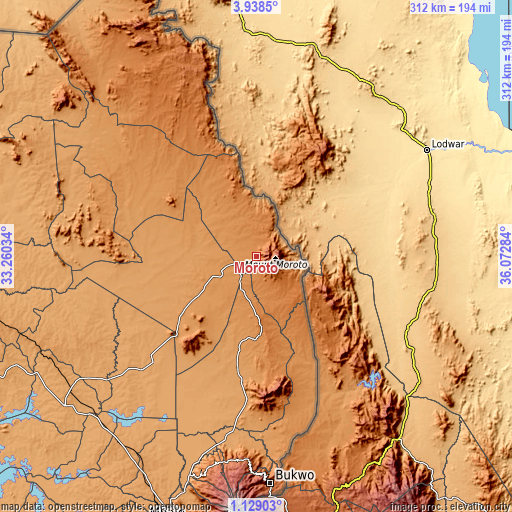
These maps also provides idea of topography and contour of this city, they are displayed at different zoom levels. More info about maps, scale and edge coordinates you can find below images.
| \ | Map #1 | Map #2 | Topo.Map |
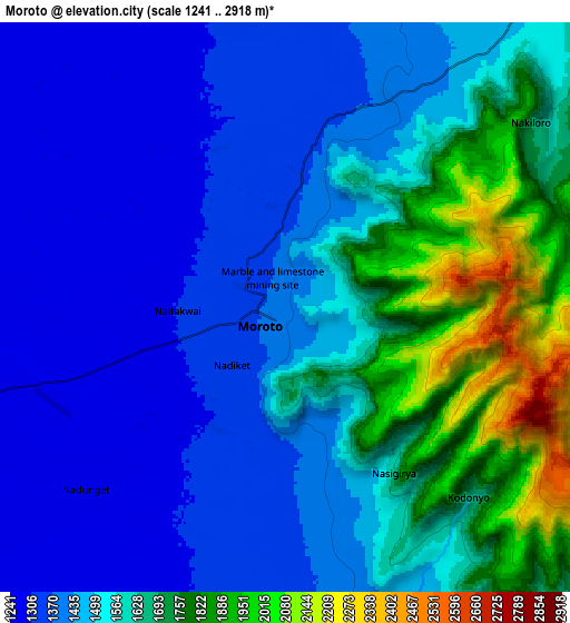
| Scale [m] | 1279..2313 m | 1241..2918 m | × |
| Scale [ft] | 4196..7589 ft | 4072..9573 ft | × |
| Average | 1490.1 m = 4889 ft | 1533.5 m = 5031 ft | × |
| Width | 9.76 km = 6.1 mi | 19.53 km = 12.1 mi | 312.4 km = 194.1 mi |
| Height | 9.76 km = 6.1 mi | 19.53 km = 12.1 mi | 312.4 km = 194.1 mi |
| ↑Max Latitude | 2.578432° | 2.622332° | 3.9385° |
| Latitude at center | 2.53453° | 2.53453° | 2.53453° |
| ↓Min Latitude | 2.490627° | 2.446722° | 1.12903° |
| ← Min Longitude | 34.622645° | 34.578699° | 33.26034° |
| Longitude center | 34.66659° | 34.66659° | 34.66659° |
| →Max Longitude | 34.710535° | 34.754481° | 36.07284° |
Nearby cities:
Cities around Moroto sort by population:
• Kotido elevation 1227 m
77.3 km,  309°
309°
• Kapchorwa 1915 m
128.3 km,  190°
190°
• Amudat 1244 m
72.2 km,  154°
154°
• Bukwa 2000 m
142.1 km,  176°
176°
• Otuke 1091 m
129.6 km,  268°
268°
• Amuria 1123 m
127.3 km,  242°
242°
• Binyin 1963 m
125.2 km, 186°
• Kaabong 1508 m
120.2 km,  331°
331°
• Abim 1468 m
111.6 km,  279°
279°
• Katakwi 1111 m
105.7 km,  227°
227°
• Nakapiripirit 1352 m
69.9 km,  169°
169°
• Napak 1162 m
56 km, 235°
Multilingual:
 En español:
Moroto elevación 1393 m.
 En France:
Moroto élévation 1393 m.


Sources and notes:
- [note 1] Map square and city borders are not equal. Map elevation data is calculated only from area inside that square.
- [src 1] Elevation data from geonames database provided with same terms of usage.
- [src 2] The elevation map of Moroto is generated using elevation data from NASA's 3 arcsec (90m) resolution SRTM data.
- [src 3] Base (background) map © OpenStreetMap contributors tiles are generated by Geofabrik and OpenTopoMap.
Copyright & License:
This Moroto Elevation Map is licensed under CC BY-SA. You may reuse any part from this page, if you give a proper credit by linking to this URL:
 More info on terms of use page.