Kapchorwa elevation
Kapchorwa (Eastern Region, Kapchorwa District), Uganda elevation is 1915 meters and Kapchorwa elevation in feet is 6283 ft above sea level [src 1]. Kapchorwa is a seat of a second-order administrative division (feature code) with elevation that is 656 meters (2152 ft) bigger than average city elevation in Uganda.
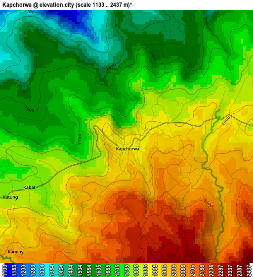
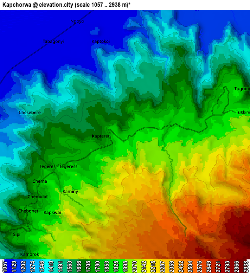
Below is the Elevation map of Kapchorwa, which displays elevation range with different colors. Scale of the first map is from 1133 to 2437 m (3717 to 7995 ft) with average elevation of 1835.3 meters (=6021 ft) [note 1]
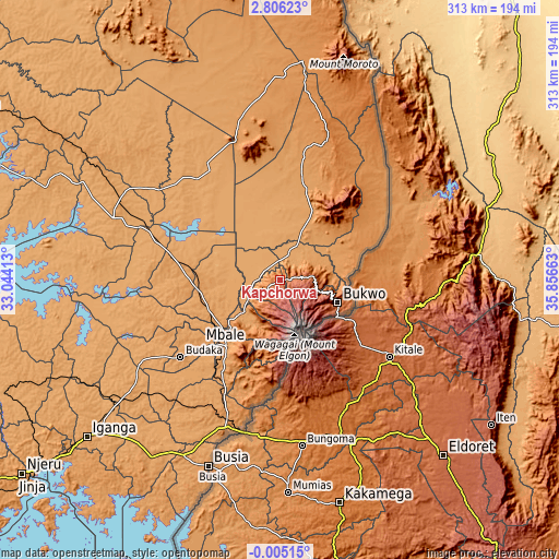
These maps also provides idea of topography and contour of this city, they are displayed at different zoom levels. More info about maps, scale and edge coordinates you can find below images.
| \ | Map #1 | Map #2 | Topo.Map |
| Scale [m] | 1133..2437 m | 1057..2938 m | × |
| Scale [ft] | 3717..7995 ft | 3468..9639 ft | × |
| Average | 1835.3 m = 6021 ft | 1771.8 m = 5813 ft | × |
| Width | 9.77 km = 6.1 mi | 19.54 km = 12.1 mi | 312.6 km = 194.2 mi |
| Height | 9.77 km = 6.1 mi | 19.54 km = 12.1 mi | 312.6 km = 194.2 mi |
| ↑Max Latitude | 1.444892° | 1.488823° | 2.80623° |
| Latitude at center | 1.40096° | 1.40096° | 1.40096° |
| ↓Min Latitude | 1.357027° | 1.313094° | -0.00515° |
| ← Min Longitude | 34.406435° | 34.362489° | 33.04413° |
| Longitude center | 34.45038° | 34.45038° | 34.45038° |
| →Max Longitude | 34.494325° | 34.538271° | 35.85663° |
Nearby cities:
Cities around Kapchorwa sort by population:
• Mbale elevation 1125 m
46.8 km,  220°
220°
• Sironko 1123 m
29.4 km,  230°
230°
• Kumi 1142 m
57.5 km,  276°
276°
• Budaka 1112 m
73.2 km, 232°
• Nakapiripirit 1352 m
68.2 km,  32°
32°
• Butebo 1128 m
63.1 km,  248°
248°
• Manafwa 1826 m
47.7 km,  190°
190°
• Bukedea 1124 m
45.4 km,  258°
258°
• Bududa 1303 m
45.3 km,  197°
197°
• Bukwa 2000 m
37.2 km,  115°
115°
• Bulambuli 1662 m
27.1 km, 195°
• Binyin 1963 m
9.4 km,  79°
79°
Multilingual:
 En español:
Kapchorwa elevación 1915 m.
 En France:
Kapchorwa élévation 1915 m.
 Auf Deutsch:
Kapchorwa höhe über dem Meeresspiegel ist 1915 m.

Sources and notes:
- [note 1] Map square and city borders are not equal. Map elevation data is calculated only from area inside that square.
- [src 1] Elevation data from geonames database provided with same terms of usage.
- [src 2] The elevation map of Kapchorwa is generated using elevation data from NASA's 3 arcsec (90m) resolution SRTM data.
- [src 3] Base (background) map © OpenStreetMap contributors tiles are generated by Geofabrik and OpenTopoMap.
Copyright & License:
This Kapchorwa Elevation Map is licensed under CC BY-SA. You may reuse any part from this page, if you give a proper credit by linking to this URL:
 More info on terms of use page.