Kotido elevation
Kotido (Northern Region, Kotido District), Uganda elevation is 1227 meters and Kotido elevation in feet is 4026 ft above sea level [src 1]. Kotido is a seat of a second-order administrative division (feature code) with elevation that is 32 meters (105 ft) smaller than average city elevation in Uganda.
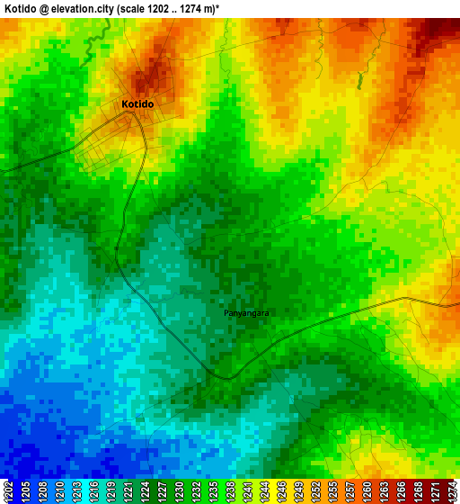
Below is the Elevation map of Kotido, which displays elevation range with different colors. Scale of the first map is from 1202 to 1274 m (3944 to 4180 ft) with average elevation of 1233 meters (=4045 ft) [note 1]
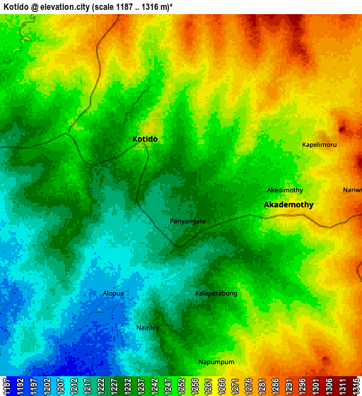
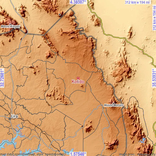
These maps also provides idea of topography and contour of this city, they are displayed at different zoom levels. More info about maps, scale and edge coordinates you can find below images.
| \ | Map #1 | Map #2 | Topo.Map |
| Scale [m] | 1202..1274 m | 1187..1316 m | × |
| Scale [ft] | 3944..4180 ft | 3894..4318 ft | × |
| Average | 1233 m = 4045 ft | 1244.9 m = 4084 ft | × |
| Width | 9.76 km = 6.1 mi | 19.52 km = 12.1 mi | 312.3 km = 194.1 mi |
| Height | 9.76 km = 6.1 mi | 19.52 km = 12.1 mi | 312.3 km = 194.1 mi |
| ↑Max Latitude | 3.024445° | 3.068328° | 4.38387° |
| Latitude at center | 2.98056° | 2.98056° | 2.98056° |
| ↓Min Latitude | 2.936673° | 2.892785° | 1.57546° |
| ← Min Longitude | 34.089115° | 34.045169° | 32.72681° |
| Longitude center | 34.13306° | 34.13306° | 34.13306° |
| →Max Longitude | 34.177005° | 34.220951° | 35.53931° |
Nearby cities:
Cities around Kotido sort by population:
• Pader elevation 1061 m
102 km,  274°
274°
• Pader Palwo 1034 m
112.6 km,  259°
259°
• Moroto 1393 m
77.3 km,  129°
129°
• Nakapiripirit 1352 m
138.6 km,  148°
148°
• Alebtong 1104 m
127.3 km,  230°
230°
• Katakwi 1111 m
122.5 km,  188°
188°
• Amuria 1123 m
121.1 km,  206°
206°
• Agago 1035 m
90.3 km, 259°
• Otuke 1091 m
88.2 km, 232°
• Napak 1162 m
82.1 km,  170°
170°
• Abim 1468 m
59.5 km,  238°
238°
• Kaabong 1508 m
56 km,  1°
1°
Multilingual:
 En español:
Kotido elevación 1227 m.
 En France:
Kotido élévation 1227 m.


Sources and notes:
- [note 1] Map square and city borders are not equal. Map elevation data is calculated only from area inside that square.
- [src 1] Elevation data from geonames database provided with same terms of usage.
- [src 2] The elevation map of Kotido is generated using elevation data from NASA's 3 arcsec (90m) resolution SRTM data.
- [src 3] Base (background) map © OpenStreetMap contributors tiles are generated by Geofabrik and OpenTopoMap.
Copyright & License:
This Kotido Elevation Map is licensed under CC BY-SA. You may reuse any part from this page, if you give a proper credit by linking to this URL:
 More info on terms of use page.