Kiboga elevation
Kiboga (Central Region, Kiboga District), Uganda elevation is 1280 meters and Kiboga elevation in feet is 4199 ft above sea level [src 1]. Kiboga is a seat of a second-order administrative division (feature code) with elevation that is 21 meters (69 ft) bigger than average city elevation in Uganda.
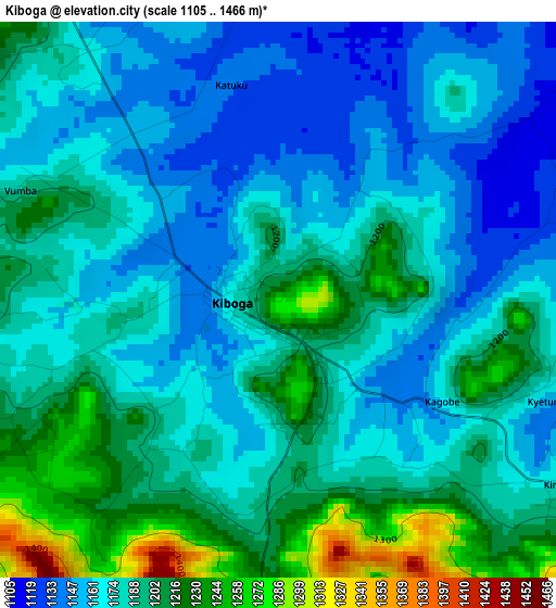
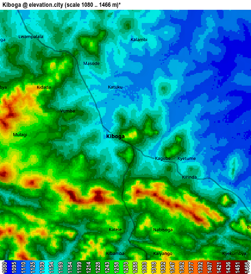
Below is the Elevation map of Kiboga, which displays elevation range with different colors. Scale of the first map is from 1105 to 1466 m (3625 to 4810 ft) with average elevation of 1183.2 meters (=3882 ft) [note 1]
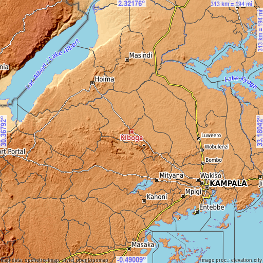
These maps also provides idea of topography and contour of this city, they are displayed at different zoom levels. More info about maps, scale and edge coordinates you can find below images.
| \ | Map #1 | Map #2 | Topo.Map |
| Scale [m] | 1105..1466 m | 1080..1466 m | × |
| Scale [ft] | 3625..4810 ft | 3543..4810 ft | × |
| Average | 1183.2 m = 3882 ft | 1191.6 m = 3909 ft | × |
| Width | 9.77 km = 6.1 mi | 19.54 km = 12.1 mi | 312.6 km = 194.2 mi |
| Height | 9.77 km = 6.1 mi | 19.54 km = 12.1 mi | 312.7 km = 194.3 mi |
| ↑Max Latitude | 0.960049° | 1.003988° | 2.32176° |
| Latitude at center | 0.91611° | 0.91611° | 0.91611° |
| ↓Min Latitude | 0.87217° | 0.82823° | -0.49009° |
| ← Min Longitude | 31.730225° | 31.686279° | 30.36792° |
| Longitude center | 31.77417° | 31.77417° | 31.77417° |
| →Max Longitude | 31.818115° | 31.862061° | 33.18042° |
Nearby cities:
Cities around Kiboga sort by population:
• Mityana elevation 1199 m
61.9 km,  153°
153°
• Hoima 1131 m
74.2 km,  320°
320°
• Masindi 1140 m
84.6 km,  355°
355°
• Luwero 1108 m
78.1 km,  95°
95°
• Wobulenzi 1155 m
84.7 km, 104°
• Namasuba 1246 m
76.2 km,  109°
109°
• Mubende 1314 m
58 km,  226°
226°
• Kibale 1367 m
79.7 km,  260°
260°
• Kanoni 1242 m
83 km,  171°
171°
• Nakaseke 1126 m
70.3 km, 105°
• Kakumiro 1311 m
52.3 km,  253°
253°
• Kyankwanzi 1091 m
31.8 km,  5°
5°
Multilingual:
 En español:
Kiboga elevación 1280 m.
 En France:
Kiboga élévation 1280 m.


Sources and notes:
- [note 1] Map square and city borders are not equal. Map elevation data is calculated only from area inside that square.
- [src 1] Elevation data from geonames database provided with same terms of usage.
- [src 2] The elevation map of Kiboga is generated using elevation data from NASA's 3 arcsec (90m) resolution SRTM data.
- [src 3] Base (background) map © OpenStreetMap contributors tiles are generated by Geofabrik and OpenTopoMap.
Copyright & License:
This Kiboga Elevation Map is licensed under CC BY-SA. You may reuse any part from this page, if you give a proper credit by linking to this URL:
 More info on terms of use page.