Hoima elevation
Hoima (Western Region, Hoima District), Uganda elevation is 1131 meters and Hoima elevation in feet is 3711 ft above sea level [src 1]. Hoima is a seat of a second-order administrative division (feature code) with elevation that is 128 meters (420 ft) smaller than average city elevation in Uganda.
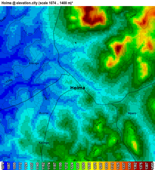
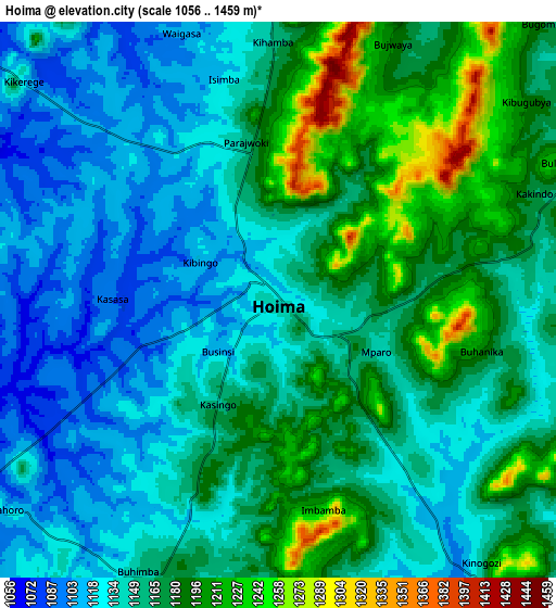
Below is the Elevation map of Hoima, which displays elevation range with different colors. Scale of the first map is from 1074 to 1400 m (3524 to 4593 ft) with average elevation of 1156 meters (=3793 ft) [note 1]
These maps also provides idea of topography and contour of this city, they are displayed at different zoom levels. More info about maps, scale and edge coordinates you can find below images.
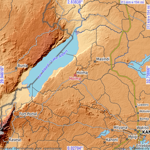
| \ | Map #1 | Map #2 | Topo.Map |
| Scale [m] | 1074..1400 m | 1056..1459 m | × |
| Scale [ft] | 3524..4593 ft | 3465..4787 ft | × |
| Average | 1156 m = 3793 ft | 1157.4 m = 3797 ft | × |
| Width | 9.77 km = 6.1 mi | 19.54 km = 12.1 mi | 312.6 km = 194.2 mi |
| Height | 9.77 km = 6.1 mi | 19.54 km = 12.1 mi | 312.6 km = 194.2 mi |
| ↑Max Latitude | 1.477071° | 1.521001° | 2.83838° |
| Latitude at center | 1.43314° | 1.43314° | 1.43314° |
| ↓Min Latitude | 1.389208° | 1.345275° | 0.02704° |
| ← Min Longitude | 31.308465° | 31.264519° | 29.94616° |
| Longitude center | 31.35241° | 31.35241° | 31.35241° |
| →Max Longitude | 31.396355° | 31.440301° | 32.75866° |
Nearby cities:
Cities around Hoima sort by population:
• Masindi elevation 1140 m
48.4 km,  56°
56°
• Mubende 1314 m
97.4 km,  177°
177°
• Kiboga 1280 m
74.2 km,  140°
140°
• Masindi Port 1039 m
86.6 km,  70°
70°
• Kigorobya 1094 m
20.9 km,  346°
346°
• Kibale 1367 m
77.2 km,  204°
204°
• Kagadi 1218 m
81.8 km,  227°
227°
• Muhororo 1191 m
85.9 km, 230°
• Kiryandongo 1086 m
93 km, 58°
• Bulisa 632 m
76.4 km,  4°
4°
• Kakumiro 1311 m
72.6 km, 182°
• Kyankwanzi 1091 m
56.1 km,  117°
117°
Multilingual:
 En español:
Hoima elevación 1131 m.
 En France:
Hoima élévation 1131 m.


Sources and notes:
- [note 1] Map square and city borders are not equal. Map elevation data is calculated only from area inside that square.
- [src 1] Elevation data from geonames database provided with same terms of usage.
- [src 2] The elevation map of Hoima is generated using elevation data from NASA's 3 arcsec (90m) resolution SRTM data.
- [src 3] Base (background) map © OpenStreetMap contributors tiles are generated by Geofabrik and OpenTopoMap.
Copyright & License:
This Hoima Elevation Map is licensed under CC BY-SA. You may reuse any part from this page, if you give a proper credit by linking to this URL:
 More info on terms of use page.