Nebbi elevation
Nebbi (Northern Region, Nebbi District), Uganda elevation is 1015 meters and Nebbi elevation in feet is 3330 ft above sea level [src 1]. Nebbi is a seat of a second-order administrative division (feature code) with elevation that is 244 meters (801 ft) smaller than average city elevation in Uganda.
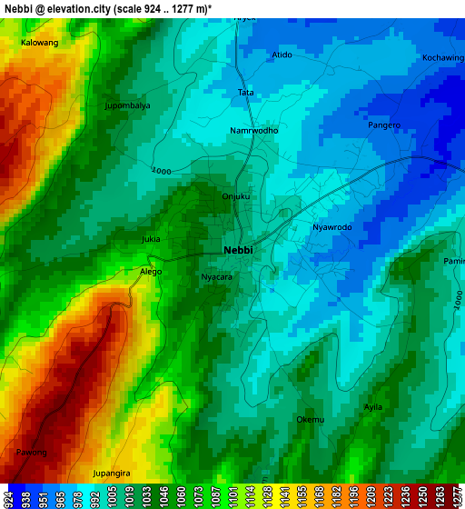
Below is the Elevation map of Nebbi, which displays elevation range with different colors. Scale of the first map is from 924 to 1277 m (3031 to 4190 ft) with average elevation of 1041.4 meters (=3417 ft) [note 1]
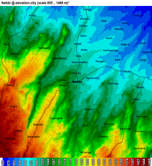
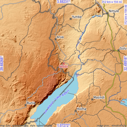
These maps also provides idea of topography and contour of this city, they are displayed at different zoom levels. More info about maps, scale and edge coordinates you can find below images.
| \ | Map #1 | Map #2 | Topo.Map |
| Scale [m] | 924..1277 m | 855..1468 m | × |
| Scale [ft] | 3031..4190 ft | 2805..4816 ft | × |
| Average | 1041.4 m = 3417 ft | 1081.3 m = 3548 ft | × |
| Width | 9.76 km = 6.1 mi | 19.53 km = 12.1 mi | 312.4 km = 194.1 mi |
| Height | 9.76 km = 6.1 mi | 19.53 km = 12.1 mi | 312.4 km = 194.1 mi |
| ↑Max Latitude | 2.522163° | 2.566065° | 3.88231° |
| Latitude at center | 2.47826° | 2.47826° | 2.47826° |
| ↓Min Latitude | 2.434355° | 2.390449° | 1.07272° |
| ← Min Longitude | 31.044985° | 31.001039° | 29.68268° |
| Longitude center | 31.08893° | 31.08893° | 31.08893° |
| →Max Longitude | 31.132875° | 31.176821° | 32.49518° |
Nearby cities:
Cities around Nebbi sort by population:
• Arua elevation 1215 m
63.4 km,  341°
341°
• Hoima 1131 m
119.8 km,  165°
165°
• Masindi 1140 m
113.3 km,  142°
142°
• Paidha 1496 m
13.4 km,  239°
239°
• Yumbe 982 m
111.1 km,  9°
9°
• Kigorobya 1094 m
98.9 km, 165°
• Koboko 1234 m
105 km,  352°
352°
• Nwoya 1025 m
102.8 km,  80°
80°
• Amuru 1075 m
101.5 km,  68°
68°
• Maracha 1182 m
89.3 km, 350°
• Bulisa 632 m
53.8 km, 138°
• Zombo 1609 m
20.4 km,  281°
281°
Multilingual:
 En español:
Nebbi elevación 1015 m.
 En France:
Nebbi élévation 1015 m.


Sources and notes:
- [note 1] Map square and city borders are not equal. Map elevation data is calculated only from area inside that square.
- [src 1] Elevation data from geonames database provided with same terms of usage.
- [src 2] The elevation map of Nebbi is generated using elevation data from NASA's 3 arcsec (90m) resolution SRTM data.
- [src 3] Base (background) map © OpenStreetMap contributors tiles are generated by Geofabrik and OpenTopoMap.
Copyright & License:
This Nebbi Elevation Map is licensed under CC BY-SA. You may reuse any part from this page, if you give a proper credit by linking to this URL:
 More info on terms of use page.