Soroti elevation
Soroti (Eastern Region, Soroti District), Uganda elevation is 1131 meters and Soroti elevation in feet is 3711 ft above sea level [src 1]. Soroti is a seat of a second-order administrative division (feature code) with elevation that is 128 meters (420 ft) smaller than average city elevation in Uganda.
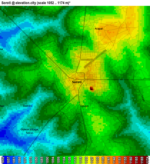
Below is the Elevation map of Soroti, which displays elevation range with different colors. Scale of the first map is from 1052 to 1174 m (3451 to 3852 ft) with average elevation of 1098 meters (=3602 ft) [note 1]
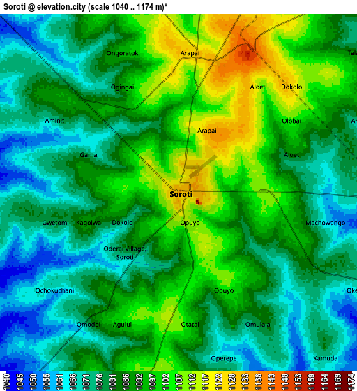
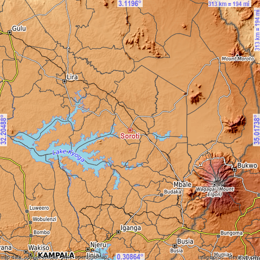
These maps also provides idea of topography and contour of this city, they are displayed at different zoom levels. More info about maps, scale and edge coordinates you can find below images.
| \ | Map #1 | Map #2 | Topo.Map |
| Scale [m] | 1052..1174 m | 1040..1174 m | × |
| Scale [ft] | 3451..3852 ft | 3412..3852 ft | × |
| Average | 1098 m = 3602 ft | 1086.4 m = 3564 ft | × |
| Width | 9.77 km = 6.1 mi | 19.54 km = 12.1 mi | 312.5 km = 194.2 mi |
| Height | 9.77 km = 6.1 mi | 19.54 km = 12.1 mi | 312.6 km = 194.2 mi |
| ↑Max Latitude | 1.758565° | 1.802489° | 3.1196° |
| Latitude at center | 1.71464° | 1.71464° | 1.71464° |
| ↓Min Latitude | 1.670714° | 1.626787° | 0.30864° |
| ← Min Longitude | 33.567185° | 33.523239° | 32.20488° |
| Longitude center | 33.61113° | 33.61113° | 33.61113° |
| →Max Longitude | 33.655075° | 33.699021° | 35.01738° |
Nearby cities:
Cities around Soroti sort by population:
• Pallisa elevation 1056 m
64.3 km,  170°
170°
• Kumi 1142 m
45.8 km,  128°
128°
• Kibuku 1107 m
77.5 km,  164°
164°
• Alebtong 1104 m
71 km,  326°
326°
• Butebo 1128 m
67.4 km,  149°
149°
• Bukedea 1124 m
65.9 km, 132°
• Dokolo 1079 m
52.3 km,  292°
292°
• Kaberamaido 1057 m
50.3 km,  273°
273°
• Katakwi 1111 m
44.1 km,  63°
63°
• Ngora 1103 m
36.5 km, 149°
• Amuria 1123 m
32.4 km,  7°
7°
• Serere 1075 m
30 km,  215°
215°
Multilingual:
 En español:
Soroti elevación 1131 m.
 En France:
Soroti élévation 1131 m.


Sources and notes:
- [note 1] Map square and city borders are not equal. Map elevation data is calculated only from area inside that square.
- [src 1] Elevation data from geonames database provided with same terms of usage.
- [src 2] The elevation map of Soroti is generated using elevation data from NASA's 3 arcsec (90m) resolution SRTM data.
- [src 3] Base (background) map © OpenStreetMap contributors tiles are generated by Geofabrik and OpenTopoMap.
Copyright & License:
This Soroti Elevation Map is licensed under CC BY-SA. You may reuse any part from this page, if you give a proper credit by linking to this URL:
 More info on terms of use page.