Kaberamaido elevation
Kaberamaido (Eastern Region, Kaberamaido District), Uganda elevation is 1057 meters and Kaberamaido elevation in feet is 3468 ft above sea level [src 1]. Kaberamaido is a seat of a second-order administrative division (feature code) with elevation that is 202 meters (663 ft) smaller than average city elevation in Uganda.
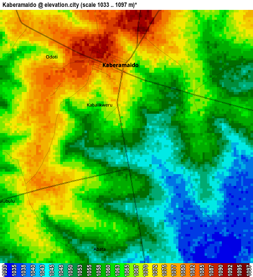
Below is the Elevation map of Kaberamaido, which displays elevation range with different colors. Scale of the first map is from 1033 to 1097 m (3389 to 3599 ft) with average elevation of 1061.2 meters (=3482 ft) [note 1]
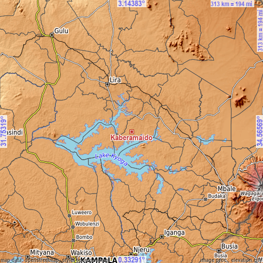
These maps also provides idea of topography and contour of this city, they are displayed at different zoom levels. More info about maps, scale and edge coordinates you can find below images.
| \ | Map #1 | Topo.Map |
| Scale [m] | 1033..1097 m | × |
| Scale [ft] | 3389..3599 ft | × |
| Average | 1061.2 m = 3482 ft | × |
| Width | 9.77 km = 6.1 mi | 312.5 km = 194.2 mi |
| Height | 9.77 km = 6.1 mi | 312.6 km = 194.2 mi |
| ↑Max Latitude | 1.782815° | 3.14383° |
| Latitude at center | 1.73889° | 1.73889° |
| ↓Min Latitude | 1.694964° | 0.33291° |
| ← Min Longitude | 33.115495° | 31.75319° |
| Longitude center | 33.15944° | 33.15944° |
| →Max Longitude | 33.203385° | 34.56569° |
Nearby cities:
Cities around Kaberamaido sort by population:
• Lira elevation 1104 m
63.7 km,  333°
333°
• Soroti 1131 m
50.3 km,  93°
93°
• Kamuli 1120 m
88.1 km,  182°
182°
• Apac 1043 m
73.8 km,  290°
290°
• Kole 1078 m
83.7 km, 331°
• Ngora 1103 m
76.7 km,  116°
116°
• Buyende 1046 m
65.3 km, 180°
• Amuria 1123 m
62.1 km,  61°
61°
• Alebtong 1104 m
57.2 km,  10°
10°
• Serere 1075 m
42.7 km,  129°
129°
• Amolatar 1041 m
38.1 km,  248°
248°
• Dokolo 1079 m
17.8 km, 6°
Multilingual:
 En español:
Kaberamaido elevación 1057 m.
 En France:
Kaberamaido élévation 1057 m.
 Auf Deutsch:
Kaberamaido höhe über dem Meeresspiegel ist 1057 m.

Sources and notes:
- [note 1] Map square and city borders are not equal. Map elevation data is calculated only from area inside that square.
- [src 1] Elevation data from geonames database provided with same terms of usage.
- [src 2] The elevation map of Kaberamaido is generated using elevation data from NASA's 3 arcsec (90m) resolution SRTM data.
- [src 3] Base (background) map © OpenStreetMap contributors tiles are generated by Geofabrik and OpenTopoMap.
Copyright & License:
This Kaberamaido Elevation Map is licensed under CC BY-SA. You may reuse any part from this page, if you give a proper credit by linking to this URL:
 More info on terms of use page.