Lira elevation
Lira (Northern Region, Lira District), Uganda elevation is 1104 meters and Lira elevation in feet is 3622 ft above sea level [src 1]. Lira is a seat of a second-order administrative division (feature code) with elevation that is 155 meters (509 ft) smaller than average city elevation in Uganda.
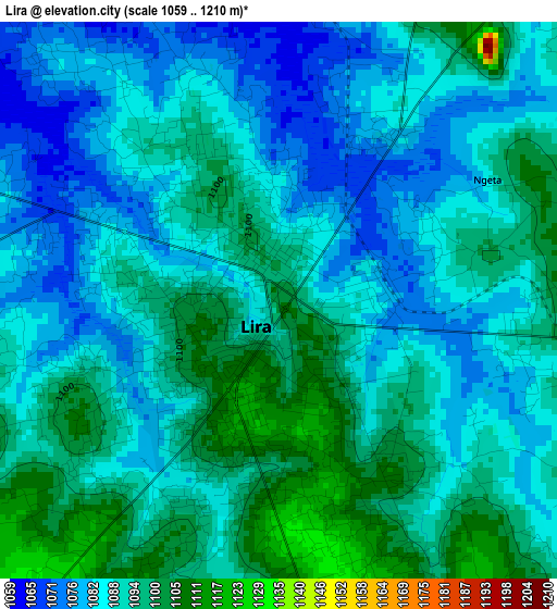
Below is the Elevation map of Lira, which displays elevation range with different colors. Scale of the first map is from 1059 to 1210 m (3474 to 3970 ft) with average elevation of 1089.5 meters (=3574 ft) [note 1]
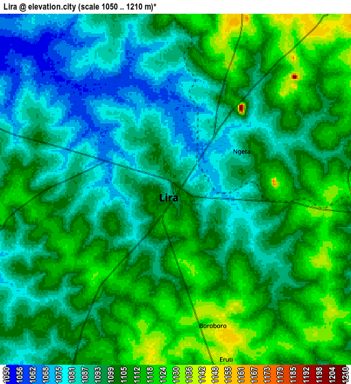
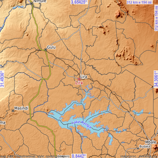
These maps also provides idea of topography and contour of this city, they are displayed at different zoom levels. More info about maps, scale and edge coordinates you can find below images.
| \ | Map #1 | Map #2 | Topo.Map |
| Scale [m] | 1059..1210 m | 1050..1210 m | × |
| Scale [ft] | 3474..3970 ft | 3445..3970 ft | × |
| Average | 1089.5 m = 3574 ft | 1099.3 m = 3607 ft | × |
| Width | 9.76 km = 6.1 mi | 19.53 km = 12.1 mi | 312.4 km = 194.1 mi |
| Height | 9.77 km = 6.1 mi | 19.53 km = 12.1 mi | 312.5 km = 194.2 mi |
| ↑Max Latitude | 2.293811° | 2.33772° | 3.65425° |
| Latitude at center | 2.2499° | 2.2499° | 2.2499° |
| ↓Min Latitude | 2.205988° | 2.162075° | 0.8442° |
| ← Min Longitude | 32.855905° | 32.811959° | 31.4936° |
| Longitude center | 32.89985° | 32.89985° | 32.89985° |
| →Max Longitude | 32.943795° | 32.987741° | 34.3061° |
Nearby cities:
Cities around Lira sort by population:
• Gulu elevation 1104 m
88.6 km,  311°
311°
• Apac 1043 m
50.4 km,  232°
232°
• Pader Palwo 1034 m
66.6 km,  23°
23°
• Amuria 1123 m
87.9 km,  108°
108°
• Agago 1035 m
80.9 km,  36°
36°
• Otuke 1091 m
72.3 km,  67°
67°
• Amolatar 1041 m
70.8 km,  185°
185°
• Kaberamaido 1057 m
63.7 km,  153°
153°
• Oyam 1053 m
57.2 km,  268°
268°
• Dokolo 1079 m
49.8 km,  141°
141°
• Alebtong 1104 m
39.4 km,  90°
90°
• Kole 1078 m
20 km,  326°
326°
Multilingual:
 En español:
Lira elevación 1104 m.
 En France:
Lira élévation 1104 m.


Sources and notes:
- [note 1] Map square and city borders are not equal. Map elevation data is calculated only from area inside that square.
- [src 1] Elevation data from geonames database provided with same terms of usage.
- [src 2] The elevation map of Lira is generated using elevation data from NASA's 3 arcsec (90m) resolution SRTM data.
- [src 3] Base (background) map © OpenStreetMap contributors tiles are generated by Geofabrik and OpenTopoMap.
Copyright & License:
This Lira Elevation Map is licensed under CC BY-SA. You may reuse any part from this page, if you give a proper credit by linking to this URL:
 More info on terms of use page.