Buyende elevation
Buyende (Eastern Region, Buyende District), Uganda elevation is 1046 meters and Buyende elevation in feet is 3432 ft above sea level [src 1]. Buyende is a seat of a second-order administrative division (feature code) with elevation that is 213 meters (699 ft) smaller than average city elevation in Uganda.
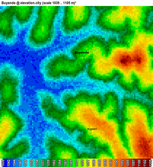
Below is the Elevation map of Buyende, which displays elevation range with different colors. Scale of the first map is from 1039 to 1105 m (3409 to 3625 ft) with average elevation of 1062.5 meters (=3486 ft) [note 1]
These maps also provides idea of topography and contour of this city, they are displayed at different zoom levels. More info about maps, scale and edge coordinates you can find below images.
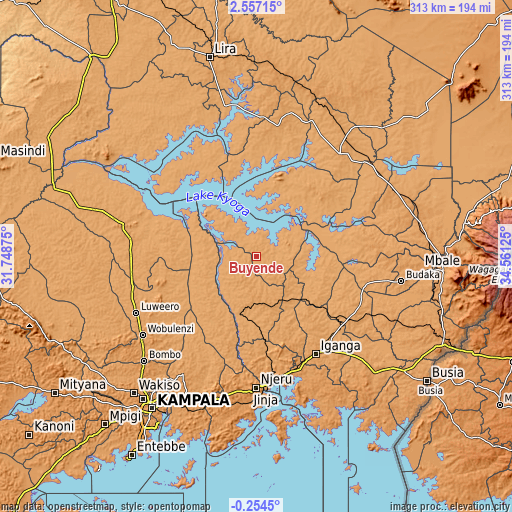
| \ | Map #1 | Topo.Map |
| Scale [m] | 1039..1105 m | × |
| Scale [ft] | 3409..3625 ft | × |
| Average | 1062.5 m = 3486 ft | × |
| Width | 9.77 km = 6.1 mi | 312.6 km = 194.2 mi |
| Height | 9.77 km = 6.1 mi | 312.7 km = 194.3 mi |
| ↑Max Latitude | 1.195606° | 2.55715° |
| Latitude at center | 1.15167° | 1.15167° |
| ↓Min Latitude | 1.107733° | -0.2545° |
| ← Min Longitude | 33.111055° | 31.74875° |
| Longitude center | 33.155° | 33.155° |
| →Max Longitude | 33.198945° | 34.56125° |
Nearby cities:
Cities around Buyende sort by population:
• Iganga elevation 1128 m
69.7 km,  149°
149°
• Pallisa 1056 m
61.6 km,  90°
90°
• Kayunga 1071 m
58.1 km,  210°
210°
• Busembatia 1123 m
66.7 km,  128°
128°
• Buwenge 1124 m
55.8 km,  178°
178°
• Kamuli 1120 m
23.1 km,  189°
189°
• Namutumba 1138 m
68.7 km,  120°
120°
• Kaberamaido 1057 m
65.3 km,  0°
0°
• Amolatar 1041 m
62.4 km,  325°
325°
• Luuka Town 1151 m
52.7 km,  162°
162°
• Serere 1075 m
50.6 km,  41°
41°
• Kaliro 1085 m
47.8 km, 126°
Multilingual:
 En español:
Buyende elevación 1046 m.
 En France:
Buyende élévation 1046 m.
 Auf Deutsch:
Buyende höhe über dem Meeresspiegel ist 1046 m.

Sources and notes:
- [note 1] Map square and city borders are not equal. Map elevation data is calculated only from area inside that square.
- [src 1] Elevation data from geonames database provided with same terms of usage.
- [src 2] The elevation map of Buyende is generated using elevation data from NASA's 3 arcsec (90m) resolution SRTM data.
- [src 3] Base (background) map © OpenStreetMap contributors tiles are generated by Geofabrik and OpenTopoMap.
Copyright & License:
This Buyende Elevation Map is licensed under CC BY-SA. You may reuse any part from this page, if you give a proper credit by linking to this URL:
 More info on terms of use page.