Ibanda elevation
Ibanda (Western Region, Ibanda District), Uganda elevation is 1439 meters and Ibanda elevation in feet is 4721 ft above sea level [src 1]. Ibanda is a seat of a second-order administrative division (feature code) with elevation that is 180 meters (591 ft) bigger than average city elevation in Uganda.
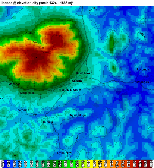
Below is the Elevation map of Ibanda, which displays elevation range with different colors. Scale of the first map is from 1324 to 1866 m (4344 to 6122 ft) with average elevation of 1451.9 meters (=4763 ft) [note 1]
These maps also provides idea of topography and contour of this city, they are displayed at different zoom levels. More info about maps, scale and edge coordinates you can find below images.
| \ | Map #1 | Map #2 | Topo.Map |
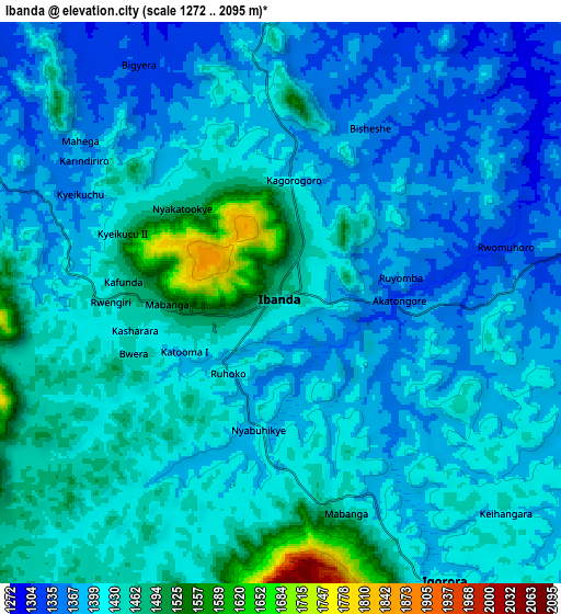
| Scale [m] | 1324..1866 m | 1272..2095 m | × |
| Scale [ft] | 4344..6122 ft | 4173..6873 ft | × |
| Average | 1451.9 m = 4763 ft | 1415 m = 4642 ft | × |
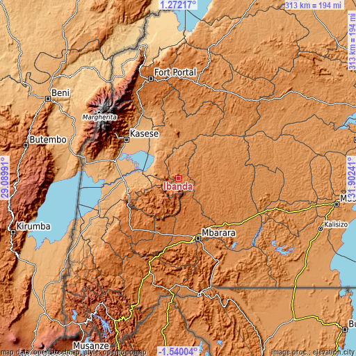
| Width | 9.77 km = 6.1 mi | 19.55 km = 12.1 mi | 312.7 km = 194.3 mi |
| Height | 9.77 km = 6.1 mi | 19.55 km = 12.1 mi | 312.7 km = 194.3 mi |
| ↑Max Latitude | -0.090035° | -0.046089° | 1.27217° |
| Latitude at center | -0.13398° | -0.13398° | -0.13398° |
| ↓Min Latitude | -0.177925° | -0.22187° | -1.54004° |
| ← Min Longitude | 30.452215° | 30.408269° | 29.08991° |
| Longitude center | 30.49616° | 30.49616° | 30.49616° |
| →Max Longitude | 30.540105° | 30.584051° | 31.90241° |
Nearby cities:
Cities around Ibanda sort by population:
• Mbarara elevation 1422 m
55 km,  162°
162°
• Bwizibwera 1415 m
53 km, 163°
• Kasese 989 m
57.9 km,  307°
307°
• Kamwenge 1253 m
36 km,  352°
352°
• Kiruhura 1344 m
39.3 km,  100°
100°
• Kilembe 1295 m
65.2 km,  304°
304°
• Mitoma 1596 m
77.4 km,  217°
217°
• Bushenyi 1607 m
56.6 km, 217°
• Kibingo 1425 m
55.1 km,  186°
186°
• Rubirizi 1338 m
44.3 km,  245°
245°
• Buhweju 1840 m
32.4 km, 222°
• Nsika 1625 m
25.9 km,  196°
196°
Multilingual:
 En español:
Ibanda elevación 1439 m.
 En France:
Ibanda élévation 1439 m.


Sources and notes:
- [note 1] Map square and city borders are not equal. Map elevation data is calculated only from area inside that square.
- [src 1] Elevation data from geonames database provided with same terms of usage.
- [src 2] The elevation map of Ibanda is generated using elevation data from NASA's 3 arcsec (90m) resolution SRTM data.
- [src 3] Base (background) map © OpenStreetMap contributors tiles are generated by Geofabrik and OpenTopoMap.
Copyright & License:
This Ibanda Elevation Map is licensed under CC BY-SA. You may reuse any part from this page, if you give a proper credit by linking to this URL:
 More info on terms of use page.