Kasese elevation
Kasese (Western Region, Kasese District), Uganda elevation is 989 meters and Kasese elevation in feet is 3245 ft above sea level [src 1]. Kasese is a seat of a second-order administrative division (feature code) with elevation that is 270 meters (886 ft) smaller than average city elevation in Uganda.
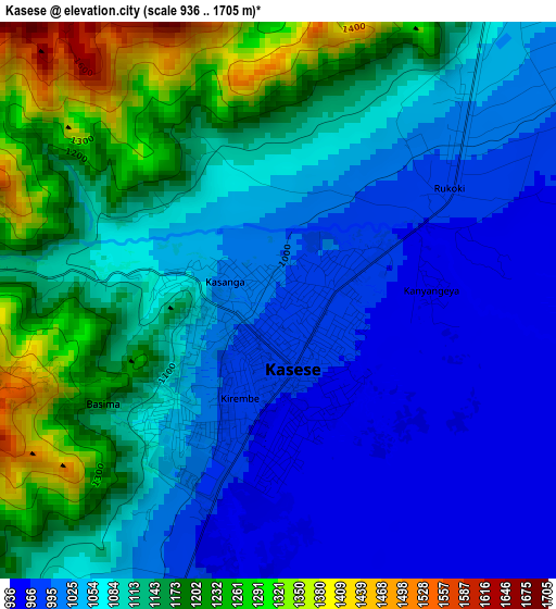
Below is the Elevation map of Kasese, which displays elevation range with different colors. Scale of the first map is from 936 to 1705 m (3071 to 5594 ft) with average elevation of 1091.8 meters (=3582 ft) [note 1]
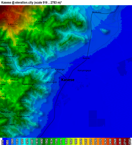
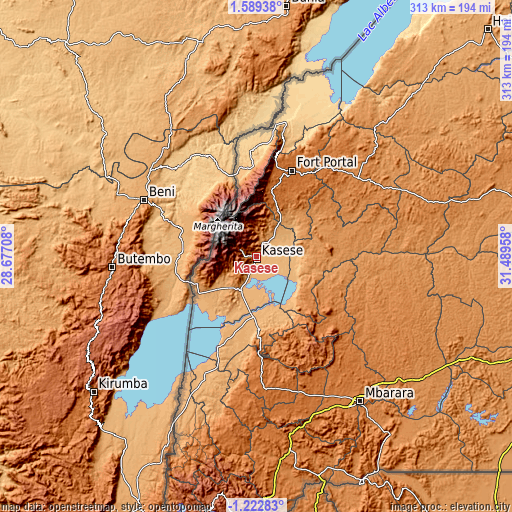
These maps also provides idea of topography and contour of this city, they are displayed at different zoom levels. More info about maps, scale and edge coordinates you can find below images.
| \ | Map #1 | Map #2 | Topo.Map |
| Scale [m] | 936..1705 m | 916..2783 m | × |
| Scale [ft] | 3071..5594 ft | 3005..9131 ft | × |
| Average | 1091.8 m = 3582 ft | 1228.4 m = 4030 ft | × |
| Width | 9.77 km = 6.1 mi | 19.55 km = 12.1 mi | 312.7 km = 194.3 mi |
| Height | 9.77 km = 6.1 mi | 19.54 km = 12.1 mi | 312.7 km = 194.3 mi |
| ↑Max Latitude | 0.227275° | 0.27122° | 1.58938° |
| Latitude at center | 0.18333° | 0.18333° | 0.18333° |
| ↓Min Latitude | 0.139385° | 0.09544° | -1.22283° |
| ← Min Longitude | 30.039385° | 29.995439° | 28.67708° |
| Longitude center | 30.08333° | 30.08333° | 30.08333° |
| →Max Longitude | 30.127275° | 30.171221° | 31.48958° |
Nearby cities:
Cities around Kasese sort by population:
• Fort Portal elevation 1518 m
57.3 km,  21°
21°
• Ibanda 1439 m
57.9 km,  127°
127°
• Kyenjojo 1334 m
78 km,  50°
50°
• Kamwenge 1253 m
41.2 km,  89°
89°
• Bundibugyo 930 m
58.7 km,  357°
357°
• Kiruhura 1344 m
94.6 km,  116°
116°
• Kilembe 1295 m
8 km,  282°
282°
• Margherita 4129 m
33.8 km,  320°
320°
• Bushenyi 1607 m
80.9 km,  171°
171°
• Nsika 1625 m
71.6 km,  147°
147°
• Buhweju 1840 m
64 km,  157°
157°
• Rubirizi 1338 m
53.9 km, 174°
Multilingual:
 En español:
Kasese elevación 989 m.
 En France:
Kasese élévation 989 m.


Sources and notes:
- [note 1] Map square and city borders are not equal. Map elevation data is calculated only from area inside that square.
- [src 1] Elevation data from geonames database provided with same terms of usage.
- [src 2] The elevation map of Kasese is generated using elevation data from NASA's 3 arcsec (90m) resolution SRTM data.
- [src 3] Base (background) map © OpenStreetMap contributors tiles are generated by Geofabrik and OpenTopoMap.
Copyright & License:
This Kasese Elevation Map is licensed under CC BY-SA. You may reuse any part from this page, if you give a proper credit by linking to this URL:
 More info on terms of use page.