Fort Portal elevation
Fort Portal (Western Region, Kabarole District), Uganda elevation is 1518 meters and Fort Portal elevation in feet is 4980 ft above sea level [src 1]. Fort Portal is a seat of a second-order administrative division (feature code) with elevation that is 259 meters (850 ft) bigger than average city elevation in Uganda.
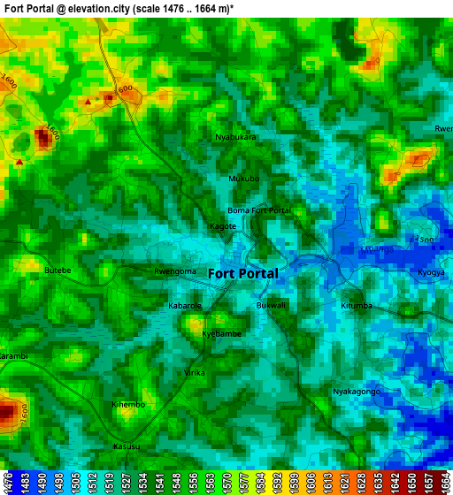
Below is the Elevation map of Fort Portal, which displays elevation range with different colors. Scale of the first map is from 1476 to 1664 m (4843 to 5459 ft) with average elevation of 1538.1 meters (=5046 ft) [note 1]
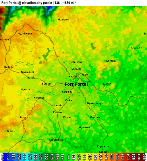
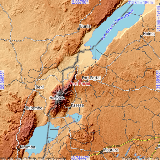
These maps also provides idea of topography and contour of this city, they are displayed at different zoom levels. More info about maps, scale and edge coordinates you can find below images.
| \ | Map #1 | Map #2 | Topo.Map |
| Scale [m] | 1476..1664 m | 1136..1880 m | × |
| Scale [ft] | 4843..5459 ft | 3727..6168 ft | × |
| Average | 1538.1 m = 5046 ft | 1538.3 m = 5047 ft | × |
| Width | 9.77 km = 6.1 mi | 19.54 km = 12.1 mi | 312.7 km = 194.3 mi |
| Height | 9.77 km = 6.1 mi | 19.54 km = 12.1 mi | 312.7 km = 194.3 mi |
| ↑Max Latitude | 0.705682° | 0.749624° | 2.06756° |
| Latitude at center | 0.66174° | 0.66174° | 0.66174° |
| ↓Min Latitude | 0.617797° | 0.573854° | -0.74447° |
| ← Min Longitude | 30.230855° | 30.186909° | 28.86855° |
| Longitude center | 30.2748° | 30.2748° | 30.2748° |
| →Max Longitude | 30.318745° | 30.362691° | 31.68105° |
Nearby cities:
Cities around Fort Portal sort by population:
• Kasese elevation 989 m
57.3 km,  201°
201°
• Ibanda 1439 m
91.8 km,  164°
164°
• Kyenjojo 1334 m
38.7 km,  94°
94°
• Kamwenge 1253 m
56.5 km, 159°
• Bundibugyo 930 m
24 km,  283°
283°
• Kilembe 1295 m
59.2 km,  209°
209°
• Kibale 1367 m
89.4 km,  80°
80°
• Margherita 4129 m
50.5 km,  237°
237°
• Kagadi 1218 m
66.8 km,  62°
62°
• Muhororo 1191 m
62 km, 60°
• Kyegegwa 1411 m
87.1 km,  101°
101°
• Ntoroko 622 m
48 km,  28°
28°
Multilingual:
 En español:
Fort Portal elevación 1518 m.
 En France:
Fort Portal élévation 1518 m.
 Auf Deutsch:
Fort Portal höhe über dem Meeresspiegel ist 1518 m.

Sources and notes:
- [note 1] Map square and city borders are not equal. Map elevation data is calculated only from area inside that square.
- [src 1] Elevation data from geonames database provided with same terms of usage.
- [src 2] The elevation map of Fort Portal is generated using elevation data from NASA's 3 arcsec (90m) resolution SRTM data.
- [src 3] Base (background) map © OpenStreetMap contributors tiles are generated by Geofabrik and OpenTopoMap.
Copyright & License:
This Fort Portal Elevation Map is licensed under CC BY-SA. You may reuse any part from this page, if you give a proper credit by linking to this URL:
 More info on terms of use page.