Margherita elevation
Margherita (Western Region, Kasese District), Uganda elevation is 4129 meters and Margherita elevation in feet is 13547 ft above sea level [src 1]. Margherita is a populated place (feature code) with elevation that is 2870 meters (9416 ft) bigger than average city elevation in Uganda.
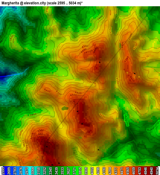
Below is the Elevation map of Margherita, which displays elevation range with different colors. Scale of the first map is from 2595 to 5034 m (8514 to 16516 ft) with average elevation of 3987.2 meters (=13081 ft) [note 1]
These maps also provides idea of topography and contour of this city, they are displayed at different zoom levels. More info about maps, scale and edge coordinates you can find below images.
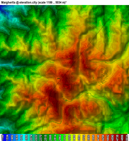
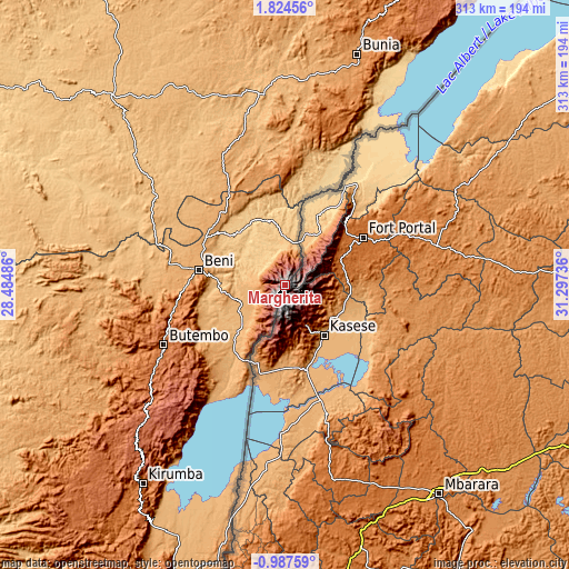
| \ | Map #1 | Map #2 | Topo.Map |
| Scale [m] | 2595..5034 m | 1186..5034 m | × |
| Scale [ft] | 8514..16516 ft | 3891..16516 ft | × |
| Average | 3987.2 m = 13081 ft | 3463 m = 11362 ft | × |
| Width | 9.77 km = 6.1 mi | 19.54 km = 12.1 mi | 312.7 km = 194.3 mi |
| Height | 9.77 km = 6.1 mi | 19.54 km = 12.1 mi | 312.7 km = 194.3 mi |
| ↑Max Latitude | 0.462554° | 0.506498° | 1.82456° |
| Latitude at center | 0.41861° | 0.41861° | 0.41861° |
| ↓Min Latitude | 0.374666° | 0.330721° | -0.98759° |
| ← Min Longitude | 29.847165° | 29.803219° | 28.48486° |
| Longitude center | 29.89111° | 29.89111° | 29.89111° |
| →Max Longitude | 29.935055° | 29.979001° | 31.29736° |
Nearby cities:
Cities around Margherita sort by population:
• Kasese elevation 989 m
33.8 km,  140°
140°
• Fort Portal 1518 m
50.5 km,  57°
57°
• Ibanda 1439 m
91.1 km,  132°
132°
• Kyenjojo 1334 m
84.6 km,  73°
73°
• Kamwenge 1253 m
67.7 km,  112°
112°
• Bundibugyo 930 m
37.8 km,  30°
30°
• Kilembe 1295 m
28 km,  151°
151°
• Bushenyi 1607 m
111.2 km,  162°
162°
• Nsika 1625 m
105.2 km, 145°
• Buhweju 1840 m
96.8 km, 151°
• Ntoroko 622 m
95.4 km,  43°
43°
• Rubirizi 1338 m
84.2 km, 161°
Multilingual:
 En español:
Margherita elevación 4129 m.
 En France:
Margherita élévation 4129 m.
 Auf Deutsch:
Margherita höhe über dem Meeresspiegel ist 4129 m.

Sources and notes:
- [note 1] Map square and city borders are not equal. Map elevation data is calculated only from area inside that square.
- [src 1] Elevation data from geonames database provided with same terms of usage.
- [src 2] The elevation map of Margherita is generated using elevation data from NASA's 3 arcsec (90m) resolution SRTM data.
- [src 3] Base (background) map © OpenStreetMap contributors tiles are generated by Geofabrik and OpenTopoMap.
Copyright & License:
This Margherita Elevation Map is licensed under CC BY-SA. You may reuse any part from this page, if you give a proper credit by linking to this URL:
 More info on terms of use page.