Adjumani elevation
Adjumani (Northern Region, Adjumani District), Uganda elevation is 816 meters and Adjumani elevation in feet is 2677 ft above sea level [src 1]. Adjumani is a seat of a second-order administrative division (feature code) with elevation that is 443 meters (1453 ft) smaller than average city elevation in Uganda.
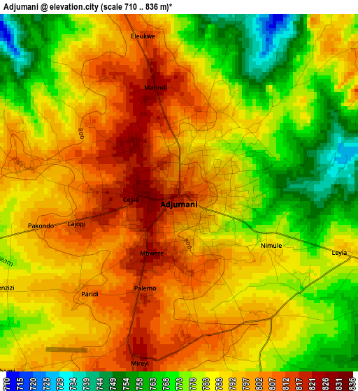
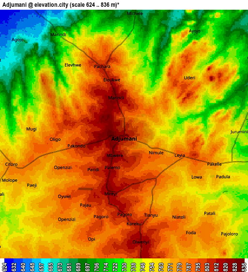
Below is the Elevation map of Adjumani, which displays elevation range with different colors. Scale of the first map is from 710 to 836 m (2329 to 2743 ft) with average elevation of 787.9 meters (=2585 ft) [note 1]
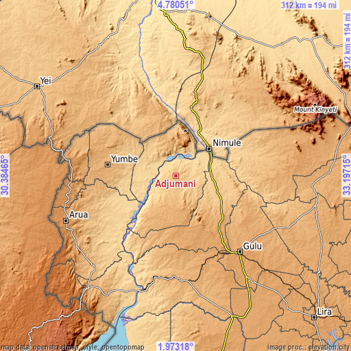
These maps also provides idea of topography and contour of this city, they are displayed at different zoom levels. More info about maps, scale and edge coordinates you can find below images.
| \ | Map #1 | Map #2 | Topo.Map |
| Scale [m] | 710..836 m | 624..836 m | × |
| Scale [ft] | 2329..2743 ft | 2047..2743 ft | × |
| Average | 787.9 m = 2585 ft | 758.4 m = 2488 ft | × |
| Width | 9.76 km = 6.1 mi | 19.51 km = 12.1 mi | 312.1 km = 193.9 mi |
| Height | 9.76 km = 6.1 mi | 19.51 km = 12.1 mi | 312.2 km = 194 mi |
| ↑Max Latitude | 3.421728° | 3.465594° | 4.78051° |
| Latitude at center | 3.37786° | 3.37786° | 3.37786° |
| ↓Min Latitude | 3.33399° | 3.290118° | 1.97318° |
| ← Min Longitude | 31.746955° | 31.703009° | 30.38465° |
| Longitude center | 31.7909° | 31.7909° | 31.7909° |
| →Max Longitude | 31.834845° | 31.878791° | 33.19715° |
Nearby cities:
Cities around Adjumani sort by population:
• Gulu elevation 1104 m
87.6 km,  139°
139°
• Kitgum 950 m
122.1 km,  95°
95°
• Arua 1215 m
105.5 km,  247°
247°
• Nebbi 1015 m
126.8 km,  217°
217°
• Yumbe 982 m
61.2 km,  279°
279°
• Moyo 973 m
32.3 km,  346°
346°
• Zombo 1609 m
137.2 km,  225°
225°
• Lamwo 1078 m
113.4 km,  81°
81°
• Maracha 1182 m
93.5 km,  262°
262°
• Koboko 1234 m
92.3 km,  272°
272°
• Nwoya 1025 m
85.9 km,  164°
164°
• Amuru 1075 m
64.8 km,  165°
165°
Multilingual:
 En español:
Adjumani elevación 816 m.
 En France:
Adjumani élévation 816 m.
 Auf Deutsch:
Adjumani höhe über dem Meeresspiegel ist 816 m.

Sources and notes:
- [note 1] Map square and city borders are not equal. Map elevation data is calculated only from area inside that square.
- [src 1] Elevation data from geonames database provided with same terms of usage.
- [src 2] The elevation map of Adjumani is generated using elevation data from NASA's 3 arcsec (90m) resolution SRTM data.
- [src 3] Base (background) map © OpenStreetMap contributors tiles are generated by Geofabrik and OpenTopoMap.
Copyright & License:
This Adjumani Elevation Map is licensed under CC BY-SA. You may reuse any part from this page, if you give a proper credit by linking to this URL:
 More info on terms of use page.