Busia elevation
Busia (Eastern Region, Busia District), Uganda elevation is 1219 meters and Busia elevation in feet is 3999 ft above sea level [src 1]. Busia is a seat of a second-order administrative division (feature code) with elevation that is 40 meters (131 ft) smaller than average city elevation in Uganda.
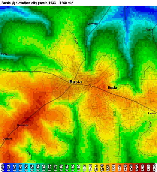
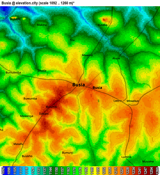
Below is the Elevation map of Busia, which displays elevation range with different colors. Scale of the first map is from 1133 to 1260 m (3717 to 4134 ft) with average elevation of 1198.6 meters (=3932 ft) [note 1]
These maps also provides idea of topography and contour of this city, they are displayed at different zoom levels. More info about maps, scale and edge coordinates you can find below images.
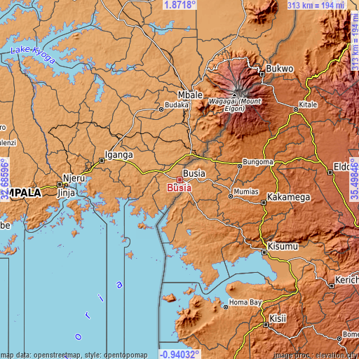
| \ | Map #1 | Map #2 | Topo.Map |
| Scale [m] | 1133..1260 m | 1092..1260 m | × |
| Scale [ft] | 3717..4134 ft | 3583..4134 ft | × |
| Average | 1198.6 m = 3932 ft | 1180.2 m = 3872 ft | × |
| Width | 9.77 km = 6.1 mi | 19.54 km = 12.1 mi | 312.7 km = 194.3 mi |
| Height | 9.77 km = 6.1 mi | 19.54 km = 12.1 mi | 312.7 km = 194.3 mi |
| ↑Max Latitude | 0.509824° | 0.553767° | 1.8718° |
| Latitude at center | 0.46588° | 0.46588° | 0.46588° |
| ↓Min Latitude | 0.421936° | 0.377992° | -0.94032° |
| ← Min Longitude | 34.048265° | 34.004319° | 32.68596° |
| Longitude center | 34.09221° | 34.09221° | 34.09221° |
| →Max Longitude | 34.136155° | 34.180101° | 35.49846° |
Nearby cities:
Cities around Busia sort by population:
• Mbale elevation 1125 m
69.1 km,  7°
7°
• Iganga 1128 m
71.1 km,  282°
282°
• Tororo 1200 m
27.1 km,  21°
21°
• Bugiri 1138 m
40.7 km,  286°
286°
• Busembatia 1123 m
62.6 km,  303°
303°
• Mayuge 1192 m
68 km,  269°
269°
• Bududa 1303 m
66.2 km, 23°
• Manafwa 1826 m
65 km,  28°
28°
• Budaka 1112 m
62.6 km,  342°
342°
• Namutumba 1138 m
61.1 km,  312°
312°
• Butaleja 1067 m
52 km, 342°
• Namayingo 1176 m
34.1 km,  222°
222°
Multilingual:
 En español:
Busia elevación 1219 m.
 En France:
Busia élévation 1219 m.


Sources and notes:
- [note 1] Map square and city borders are not equal. Map elevation data is calculated only from area inside that square.
- [src 1] Elevation data from geonames database provided with same terms of usage.
- [src 2] The elevation map of Busia is generated using elevation data from NASA's 3 arcsec (90m) resolution SRTM data.
- [src 3] Base (background) map © OpenStreetMap contributors tiles are generated by Geofabrik and OpenTopoMap.
Copyright & License:
This Busia Elevation Map is licensed under CC BY-SA. You may reuse any part from this page, if you give a proper credit by linking to this URL:
 More info on terms of use page.