Nyachera elevation
Nyachera (Western Region, Ntungamo District), Uganda elevation is 1407 meters and Nyachera elevation in feet is 4616 ft above sea level [src 1]. Nyachera is a populated place (feature code) with elevation that is 148 meters (486 ft) bigger than average city elevation in Uganda.
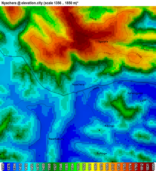
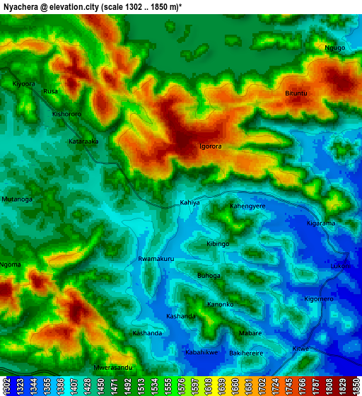
Below is the Elevation map of Nyachera, which displays elevation range with different colors. Scale of the first map is from 1356 to 1850 m (4449 to 6070 ft) with average elevation of 1516.3 meters (=4975 ft) [note 1]
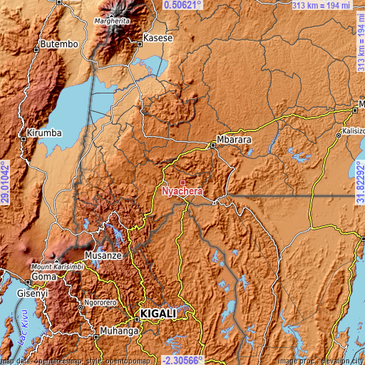
These maps also provides idea of topography and contour of this city, they are displayed at different zoom levels. More info about maps, scale and edge coordinates you can find below images.
| \ | Map #1 | Map #2 | Topo.Map |
| Scale [m] | 1356..1850 m | 1302..1850 m | × |
| Scale [ft] | 4449..6070 ft | 4272..6070 ft | × |
| Average | 1516.3 m = 4975 ft | 1496.1 m = 4908 ft | × |
| Width | 9.77 km = 6.1 mi | 19.54 km = 12.1 mi | 312.7 km = 194.3 mi |
| Height | 9.77 km = 6.1 mi | 19.54 km = 12.1 mi | 312.7 km = 194.3 mi |
| ↑Max Latitude | -0.85606° | -0.812119° | 0.50621° |
| Latitude at center | -0.9° | -0.9° | -0.9° |
| ↓Min Latitude | -0.94394° | -0.987879° | -2.30566° |
| ← Min Longitude | 30.372725° | 30.328779° | 29.01042° |
| Longitude center | 30.41667° | 30.41667° | 30.41667° |
| →Max Longitude | 30.460615° | 30.504561° | 31.82292° |
Nearby cities:
Cities around Nyachera sort by population:
• Mbarara elevation 1422 m
41.7 km,  38°
38°
• Bwizibwera 1415 m
41.6 km,  34°
34°
• Kabale 1831 m
61.3 km,  230°
230°
• Ntungamo 1423 m
17.1 km,  277°
277°
• Kanungu 1551 m
70 km,  264°
264°
• Rukungiri 1575 m
53.2 km, 277°
• Buhweju 1840 m
62.5 km,  348°
348°
• Nsika 1625 m
60.3 km,  1°
1°
• Bushenyi 1607 m
47.8 km,  327°
327°
• Isingiro 1389 m
46.1 km,  85°
85°
• Mitoma 1596 m
45.4 km,  301°
301°
• Kibingo 1425 m
30.5 km, 4°
Multilingual:
 En español:
Nyachera elevación 1407 m.
 En France:
Nyachera élévation 1407 m.
 Auf Deutsch:
Nyachera höhe über dem Meeresspiegel ist 1407 m.

Sources and notes:
- [note 1] Map square and city borders are not equal. Map elevation data is calculated only from area inside that square.
- [src 1] Elevation data from geonames database provided with same terms of usage.
- [src 2] The elevation map of Nyachera is generated using elevation data from NASA's 3 arcsec (90m) resolution SRTM data.
- [src 3] Base (background) map © OpenStreetMap contributors tiles are generated by Geofabrik and OpenTopoMap.
Copyright & License:
This Nyachera Elevation Map is licensed under CC BY-SA. You may reuse any part from this page, if you give a proper credit by linking to this URL:
 More info on terms of use page.