Lyantonde elevation
Lyantonde (Central Region, Lyantonde District), Uganda elevation is 1261 meters and Lyantonde elevation in feet is 4137 ft above sea level [src 1]. Lyantonde is a seat of a second-order administrative division (feature code) with elevation that is 2 meters (7 ft) bigger than average city elevation in Uganda.
Below is the Elevation map of Lyantonde, which displays elevation range with different colors. Scale of the first map is from 1236 to 1485 m (4055 to 4872 ft) with average elevation of 1276.2 meters (=4187 ft) [note 1]
These maps also provides idea of topography and contour of this city, they are displayed at different zoom levels. More info about maps, scale and edge coordinates you can find below images.
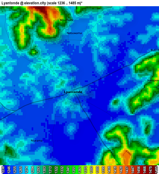
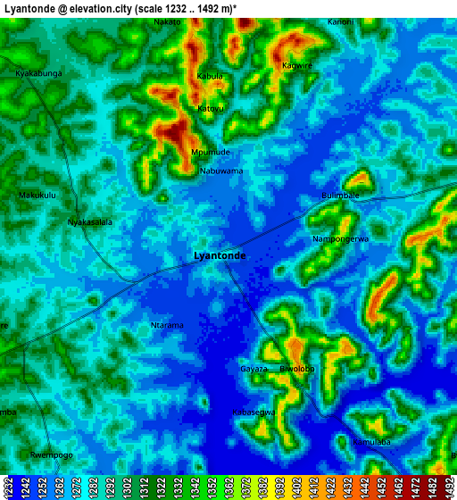
| \ | Map #1 | Map #2 | Topo.Map |
| Scale [m] | 1236..1485 m | 1232..1492 m | × |
| Scale [ft] | 4055..4872 ft | 4042..4895 ft | × |
| Average | 1276.2 m = 4187 ft | 1290.4 m = 4234 ft | × |
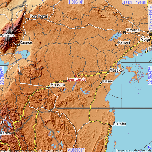
| Width | 9.77 km = 6.1 mi | 19.54 km = 12.1 mi | 312.7 km = 194.3 mi |
| Height | 9.77 km = 6.1 mi | 19.54 km = 12.1 mi | 312.7 km = 194.3 mi |
| ↑Max Latitude | -0.359116° | -0.315171° | 1.00314° |
| Latitude at center | -0.40306° | -0.40306° | -0.40306° |
| ↓Min Latitude | -0.447004° | -0.490948° | -1.80901° |
| ← Min Longitude | 31.113275° | 31.069329° | 29.75097° |
| Longitude center | 31.15722° | 31.15722° | 31.15722° |
| →Max Longitude | 31.201165° | 31.245111° | 32.56347° |
Nearby cities:
Cities around Lyantonde sort by population:
• Mbarara elevation 1422 m
60.8 km,  248°
248°
• Bwizibwera 1415 m
62.4 km, 250°
• Masaka 1292 m
64.6 km,  83°
83°
• Kiruhura 1344 m
41.7 km,  303°
303°
• Kyotera 1202 m
46.5 km,  120°
120°
• Byakabanda 1243 m
46.8 km,  143°
143°
• Sembabule 1232 m
49.2 km,  42°
42°
• Isingiro 1389 m
63.3 km,  215°
215°
• Bukomansimbi 1249 m
56.7 km,  61°
61°
• Rakai 1301 m
50.6 km,  134°
134°
• Kasaali 1179 m
49.7 km, 118°
• Lwengo 1252 m
27.9 km,  92°
92°
Multilingual:
 En español:
Lyantonde elevación 1261 m.
 En France:
Lyantonde élévation 1261 m.
 Auf Deutsch:
Lyantonde höhe über dem Meeresspiegel ist 1261 m.

Sources and notes:
- [note 1] Map square and city borders are not equal. Map elevation data is calculated only from area inside that square.
- [src 1] Elevation data from geonames database provided with same terms of usage.
- [src 2] The elevation map of Lyantonde is generated using elevation data from NASA's 3 arcsec (90m) resolution SRTM data.
- [src 3] Base (background) map © OpenStreetMap contributors tiles are generated by Geofabrik and OpenTopoMap.
Copyright & License:
This Lyantonde Elevation Map is licensed under CC BY-SA. You may reuse any part from this page, if you give a proper credit by linking to this URL:
 More info on terms of use page.