San Miguel de Cruces elevation
San Miguel de Cruces (Durango, San Dimas), Mexico elevation is 2639 meters and San Miguel de Cruces elevation in feet is 8658 ft above sea level [src 1]. San Miguel de Cruces is a populated place (feature code) with elevation that is 1325 meters (4347 ft) bigger than average city elevation in Mexico.
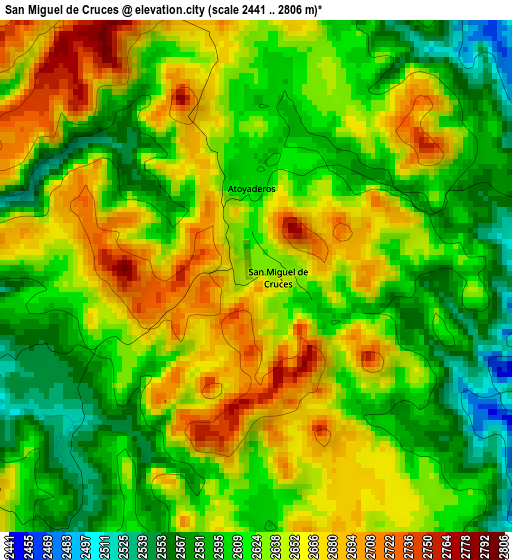
Below is the Elevation map of San Miguel de Cruces, which displays elevation range with different colors. Scale of the first map is from 2441 to 2806 m (8009 to 9206 ft) with average elevation of 2628 meters (=8622 ft) [note 1]
These maps also provides idea of topography and contour of this city, they are displayed at different zoom levels. More info about maps, scale and edge coordinates you can find below images.
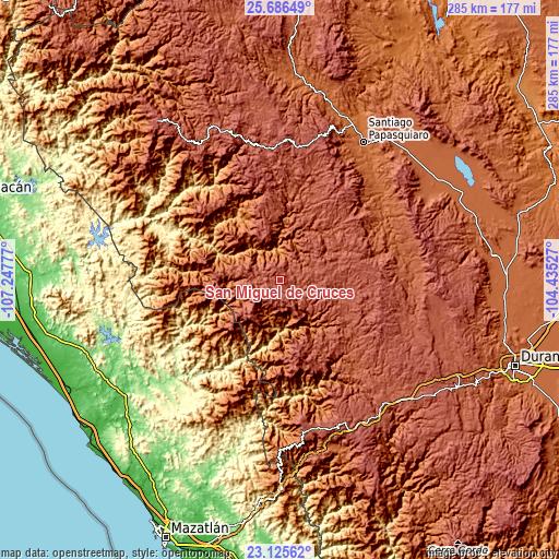
| \ | Map #1 | Topo.Map |
| Scale [m] | 2441..2806 m | × |
| Scale [ft] | 8009..9206 ft | × |
| Average | 2628 m = 8622 ft | × |
| Width | 8.9 km = 5.5 mi | 284.7 km = 176.9 mi |
| Height | 8.9 km = 5.5 mi | 284.8 km = 177 mi |
| ↑Max Latitude | 24.45256° | 25.68649° |
| Latitude at center | 24.41255° | 24.41255° |
| ↓Min Latitude | 24.372527° | 23.12562° |
| ← Min Longitude | -105.885465° | -107.24777° |
| Longitude center | -105.84152° | -105.84152° |
| →Max Longitude | -105.797575° | -104.43527° |
Nearby cities:
Cities around San Miguel de Cruces sort by population:
• Santiago Papasquiaro elevation 1728 m
82.1 km,  31°
31°
• El Salto 2543 m
85.7 km,  145°
145°
• Nuevo Ideal 1995 m
93.6 km,  55°
55°
• Cosalá 389 m
86 km,  270°
270°
• Tayoltita 536 m
35.6 km,  194°
194°
• San Ignacio 159 m
79 km,  228°
228°
• La Ciudad 2570 m
77.4 km,  168°
168°
• Llano Grande 2403 m
88.8 km,  133°
133°
• Ciénega de Nuestra Señora de Guadalupe 2490 m
87.4 km,  325°
325°
• José María Morelos 2031 m
92.4 km,  43°
43°
• Banderas del Águila 2402 m
74.3 km,  136°
136°
• Otaéz 1711 m
35.6 km, 334°
Multilingual:
 En español:
San Miguel de Cruces elevación 2639 m.
 En France:
San Miguel de Cruces élévation 2639 m.
 Auf Deutsch:
San Miguel de Cruces höhe über dem Meeresspiegel ist 2639 m.
 На русском:
San Miguel de Cruces высота над уровнем моря 2639 м
Sources and notes:
- [note 1] Map square and city borders are not equal. Map elevation data is calculated only from area inside that square.
- [src 1] Elevation data from geonames database provided with same terms of usage.
- [src 2] The elevation map of San Miguel de Cruces is generated using elevation data from NASA's 3 arcsec (90m) resolution SRTM data.
- [src 3] Base (background) map © OpenStreetMap contributors tiles are generated by Geofabrik and OpenTopoMap.
Copyright & License:
This San Miguel de Cruces Elevation Map is licensed under CC BY-SA. You may reuse any part from this page, if you give a proper credit by linking to this URL:
 More info on terms of use page.