San Ignacio elevation
San Ignacio (Sinaloa), Mexico elevation is 159 meters and San Ignacio elevation in feet is 522 ft above sea level [src 1]. San Ignacio is a seat of a second-order administrative division (feature code) with elevation that is 1155 meters (3789 ft) smaller than average city elevation in Mexico.
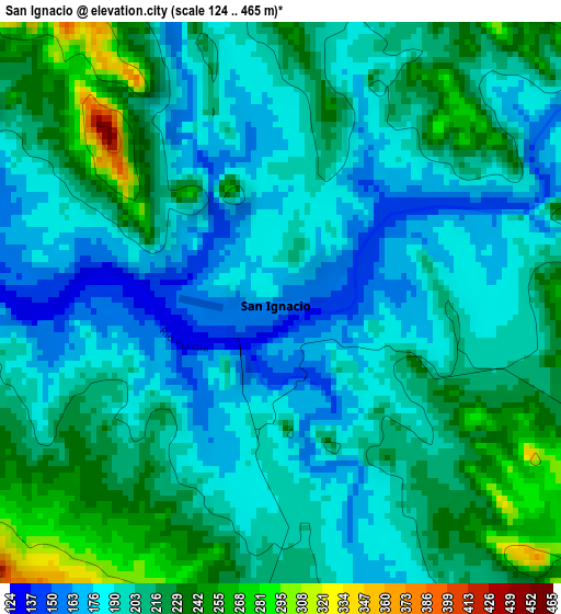
Below is the Elevation map of San Ignacio, which displays elevation range with different colors. Scale of the first map is from 124 to 465 m (407 to 1526 ft) with average elevation of 203.3 meters (=667 ft) [note 1]
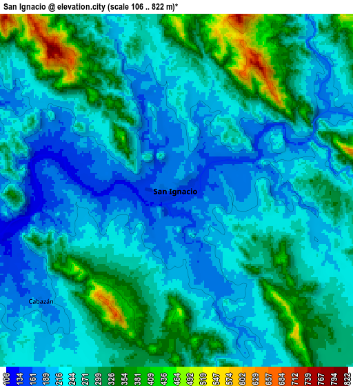
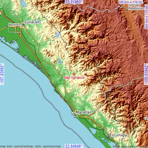
These maps also provides idea of topography and contour of this city, they are displayed at different zoom levels. More info about maps, scale and edge coordinates you can find below images.
| \ | Map #1 | Map #2 | Topo.Map |
| Scale [m] | 124..465 m | 106..822 m | × |
| Scale [ft] | 407..1526 ft | 348..2697 ft | × |
| Average | 203.3 m = 667 ft | 262.3 m = 861 ft | × |
| Width | 8.93 km = 5.5 mi | 17.86 km = 11.1 mi | 285.8 km = 177.6 mi |
| Height | 8.93 km = 5.5 mi | 17.86 km = 11.1 mi | 285.8 km = 177.6 mi |
| ↑Max Latitude | 23.981208° | 24.021354° | 25.21983° |
| Latitude at center | 23.94105° | 23.94105° | 23.94105° |
| ↓Min Latitude | 23.900879° | 23.860696° | 22.64948° |
| ← Min Longitude | -106.468615° | -106.512561° | -107.83092° |
| Longitude center | -106.42467° | -106.42467° | -106.42467° |
| →Max Longitude | -106.380725° | -106.336779° | -105.01842° |
Nearby cities:
Cities around San Ignacio sort by population:
• La Cruz elevation 32 m
47.6 km,  267°
267°
• Tayoltita 536 m
53.3 km,  70°
70°
• El Carrizo 50 m
44.2 km,  280°
280°
• Piaxtla de Abajo 36 m
26.7 km,  243°
243°
• El Quelite 38 m
42.7 km,  185°
185°
• Pueblo Nuevo 20 m
54.3 km, 275°
• Coyotitán 81 m
24.2 km,  227°
227°
• Potrerillo del Norote 17 m
56.5 km, 279°
• El Saladito 47 m
43.7 km,  259°
259°
• Empaque Tarriba 7 m
51.7 km, 264°
• La Noria de San Antonio 121 m
49.6 km,  166°
166°
• Ceuta 8 m
51.4 km, 264°
Multilingual:
 En español:
San Ignacio elevación 159 m.
 En France:
San Ignacio élévation 159 m.
 Auf Deutsch:
San Ignacio höhe über dem Meeresspiegel ist 159 m.

Sources and notes:
- [note 1] Map square and city borders are not equal. Map elevation data is calculated only from area inside that square.
- [src 1] Elevation data from geonames database provided with same terms of usage.
- [src 2] The elevation map of San Ignacio is generated using elevation data from NASA's 3 arcsec (90m) resolution SRTM data.
- [src 3] Base (background) map © OpenStreetMap contributors tiles are generated by Geofabrik and OpenTopoMap.
Copyright & License:
This San Ignacio Elevation Map is licensed under CC BY-SA. You may reuse any part from this page, if you give a proper credit by linking to this URL:
 More info on terms of use page.