La Cruz elevation
La Cruz (Sinaloa, Elota), Mexico elevation is 32 meters and La Cruz elevation in feet is 105 ft above sea level [src 1]. La Cruz is a populated place (feature code) with elevation that is 1282 meters (4206 ft) smaller than average city elevation in Mexico.
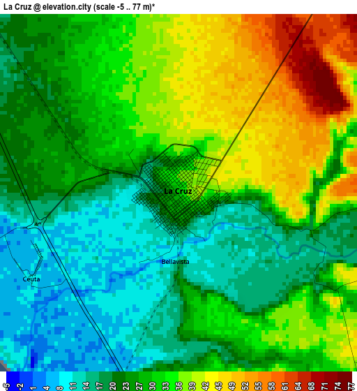
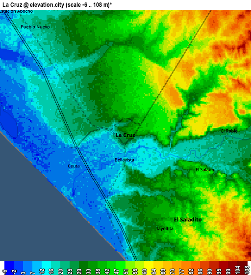
Below is the Elevation map of La Cruz, which displays elevation range with different colors. Scale of the first map is from -5 to 77 m (-16 to 253 ft) with average elevation of 28 meters (=92 ft) [note 1]
These maps also provides idea of topography and contour of this city, they are displayed at different zoom levels. More info about maps, scale and edge coordinates you can find below images.
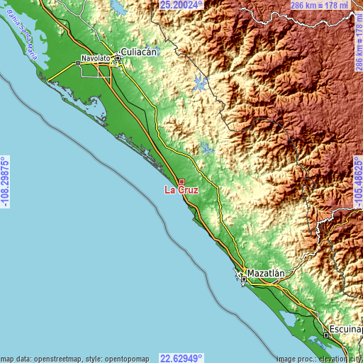
| \ | Map #1 | Map #2 | Topo.Map |
| Scale [m] | -5..77 m | -6..108 m | × |
| Scale [ft] | -16..253 ft | -20..354 ft | × |
| Average | 28 m = 92 ft | 35.2 m = 115 ft | × |
| Width | 8.93 km = 5.5 mi | 17.87 km = 11.1 mi | 285.8 km = 177.6 mi |
| Height | 8.93 km = 5.5 mi | 17.87 km = 11.1 mi | 285.9 km = 177.6 mi |
| ↑Max Latitude | 23.961424° | 24.001576° | 25.20024° |
| Latitude at center | 23.92126° | 23.92126° | 23.92126° |
| ↓Min Latitude | 23.881083° | 23.840894° | 22.62949° |
| ← Min Longitude | -106.936445° | -106.980391° | -108.29875° |
| Longitude center | -106.8925° | -106.8925° | -106.8925° |
| →Max Longitude | -106.848555° | -106.804609° | -105.48625° |
Nearby cities:
Cities around La Cruz sort by population:
• El Rosario elevation 17 m
47.4 km,  321°
321°
• El Carrizo 50 m
11.1 km,  21°
21°
• San Ignacio 159 m
47.6 km,  87°
87°
• Piaxtla de Abajo 36 m
25.7 km,  112°
112°
• Pueblo Nuevo 20 m
10.1 km, 320°
• Coyotitán 81 m
32.9 km,  115°
115°
• Tanques 24 m
20 km, 322°
• Higueras de Abuya 64 m
41.8 km,  334°
334°
• Potrerillo del Norote 17 m
13.9 km, 323°
• El Saladito 47 m
7.3 km,  141°
141°
• Empaque Tarriba 7 m
4.6 km,  239°
239°
• Ceuta 8 m
4.3 km, 237°
Multilingual:
 En español:
La Cruz elevación 32 m.
 En France:
La Cruz élévation 32 m.


Sources and notes:
- [note 1] Map square and city borders are not equal. Map elevation data is calculated only from area inside that square.
- [src 1] Elevation data from geonames database provided with same terms of usage.
- [src 2] The elevation map of La Cruz is generated using elevation data from NASA's 3 arcsec (90m) resolution SRTM data.
- [src 3] Base (background) map © OpenStreetMap contributors tiles are generated by Geofabrik and OpenTopoMap.
Copyright & License:
This La Cruz Elevation Map is licensed under CC BY-SA. You may reuse any part from this page, if you give a proper credit by linking to this URL:
 More info on terms of use page.