Tayoltita elevation
Tayoltita (Durango, San Dimas), Mexico elevation is 536 meters and Tayoltita elevation in feet is 1759 ft above sea level [src 1]. Tayoltita is a populated place (feature code) with elevation that is 778 meters (2552 ft) smaller than average city elevation in Mexico.
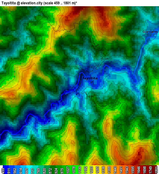
Below is the Elevation map of Tayoltita, which displays elevation range with different colors. Scale of the first map is from 459 to 1801 m (1506 to 5909 ft) with average elevation of 964.8 meters (=3165 ft) [note 1]
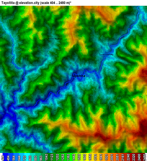
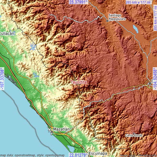
These maps also provides idea of topography and contour of this city, they are displayed at different zoom levels. More info about maps, scale and edge coordinates you can find below images.
| \ | Map #1 | Map #2 | Topo.Map |
| Scale [m] | 459..1801 m | 404..2480 m | × |
| Scale [ft] | 1506..5909 ft | 1325..8136 ft | × |
| Average | 964.8 m = 3165 ft | 1191.7 m = 3910 ft | × |
| Width | 8.92 km = 5.5 mi | 17.84 km = 11.1 mi | 285.4 km = 177.3 mi |
| Height | 8.92 km = 5.5 mi | 17.84 km = 11.1 mi | 285.5 km = 177.4 mi |
| ↑Max Latitude | 24.142888° | 24.182983° | 25.37991° |
| Latitude at center | 24.10278° | 24.10278° | 24.10278° |
| ↓Min Latitude | 24.06266° | 24.022527° | 22.81279° |
| ← Min Longitude | -105.974775° | -106.018721° | -107.33708° |
| Longitude center | -105.93083° | -105.93083° | -105.93083° |
| →Max Longitude | -105.886885° | -105.842939° | -104.52458° |
Nearby cities:
Cities around Tayoltita sort by population:
• El Salto elevation 2543 m
68.2 km,  122°
122°
• San Ignacio 159 m
53.3 km,  250°
250°
• La Ciudad 2570 m
48.1 km,  149°
149°
• Llano Grande 2403 m
78.3 km,  109°
109°
• Piaxtla de Abajo 36 m
79.9 km, 247°
• San Miguel de Cruces 2639 m
35.6 km,  14°
14°
• El Quelite 38 m
81.5 km,  222°
222°
• Coyotitán 81 m
76.2 km,  243°
243°
• Banderas del Águila 2402 m
63.2 km, 108°
• La Noria de San Antonio 121 m
76.9 km,  210°
210°
• La Concepción 78 m
82.4 km,  197°
197°
• Otaéz 1711 m
66.8 km,  354°
354°
Multilingual:
 En español:
Tayoltita elevación 536 m.
 En France:
Tayoltita élévation 536 m.
 Auf Deutsch:
Tayoltita höhe über dem Meeresspiegel ist 536 m.

Sources and notes:
- [note 1] Map square and city borders are not equal. Map elevation data is calculated only from area inside that square.
- [src 1] Elevation data from geonames database provided with same terms of usage.
- [src 2] The elevation map of Tayoltita is generated using elevation data from NASA's 3 arcsec (90m) resolution SRTM data.
- [src 3] Base (background) map © OpenStreetMap contributors tiles are generated by Geofabrik and OpenTopoMap.
Copyright & License:
This Tayoltita Elevation Map is licensed under CC BY-SA. You may reuse any part from this page, if you give a proper credit by linking to this URL:
 More info on terms of use page.