Otaéz elevation
Otaéz (Durango, Otáez), Mexico elevation is 1711 meters and Otaéz elevation in feet is 5614 ft above sea level [src 1]. Otaéz is a seat of a second-order administrative division (feature code) with elevation that is 397 meters (1302 ft) bigger than average city elevation in Mexico.
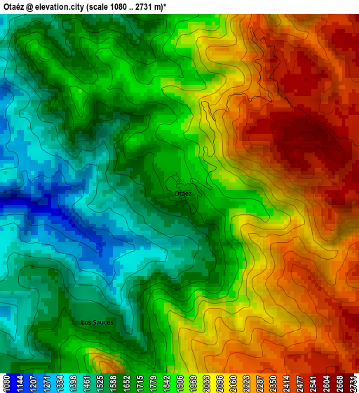
Below is the Elevation map of Otaéz, which displays elevation range with different colors. Scale of the first map is from 1080 to 2731 m (3543 to 8960 ft) with average elevation of 1886.8 meters (=6190 ft) [note 1]
These maps also provides idea of topography and contour of this city, they are displayed at different zoom levels. More info about maps, scale and edge coordinates you can find below images.
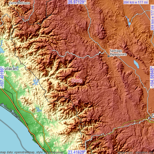
| \ | Map #1 | Topo.Map |
| Scale [m] | 1080..2731 m | × |
| Scale [ft] | 3543..8960 ft | × |
| Average | 1886.8 m = 6190 ft | × |
| Width | 8.88 km = 5.5 mi | 284.1 km = 176.5 mi |
| Height | 8.88 km = 5.5 mi | 284.1 km = 176.5 mi |
| ↑Max Latitude | 24.740258° | 25.97129° |
| Latitude at center | 24.70034° | 24.70034° |
| ↓Min Latitude | 24.660409° | 23.41629° |
| ← Min Longitude | -106.039645° | -107.40195° |
| Longitude center | -105.9957° | -105.9957° |
| →Max Longitude | -105.951755° | -104.58945° |
Nearby cities:
Cities around Otaéz sort by population:
• Santiago Papasquiaro elevation 1728 m
69.6 km,  56°
56°
• Nuevo Ideal 1995 m
95.1 km,  77°
77°
• Cosalá 389 m
77.1 km,  245°
245°
• Tayoltita 536 m
66.8 km,  174°
174°
• Santa Catarina de Tepehuanes 1809 m
76.2 km,  21°
21°
• San Ignacio 159 m
95 km,  207°
207°
• Topia 1745 m
81.2 km,  314°
314°
• San Miguel de Cruces 2639 m
35.6 km,  154°
154°
• Ciénega de Nuestra Señora de Guadalupe 2490 m
52.4 km,  320°
320°
• José María Morelos 2031 m
86.7 km,  66°
66°
• Esfuerzos Unidos 1981 m
102.4 km, 82°
• Canelas 1342 m
72.8 km, 310°
Multilingual:
 En español:
Santa María de Otaez elevación 1711 m.
 En France:
Otaéz élévation 1711 m.


Sources and notes:
- [note 1] Map square and city borders are not equal. Map elevation data is calculated only from area inside that square.
- [src 1] Elevation data from geonames database provided with same terms of usage.
- [src 2] The elevation map of Otaéz is generated using elevation data from NASA's 3 arcsec (90m) resolution SRTM data.
- [src 3] Base (background) map © OpenStreetMap contributors tiles are generated by Geofabrik and OpenTopoMap.
Copyright & License:
This Otaéz Elevation Map is licensed under CC BY-SA. You may reuse any part from this page, if you give a proper credit by linking to this URL:
 More info on terms of use page.