Cosalá elevation
Cosalá (Sinaloa), Mexico elevation is 389 meters and Cosalá elevation in feet is 1276 ft above sea level [src 1]. Cosalá is a seat of a second-order administrative division (feature code) with elevation that is 925 meters (3035 ft) smaller than average city elevation in Mexico.
Below is the Elevation map of Cosalá, which displays elevation range with different colors. Scale of the first map is from 329 to 972 m (1079 to 3189 ft) with average elevation of 473.7 meters (=1554 ft) [note 1]
These maps also provides idea of topography and contour of this city, they are displayed at different zoom levels. More info about maps, scale and edge coordinates you can find below images.
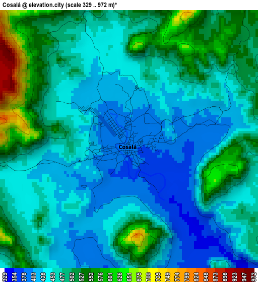
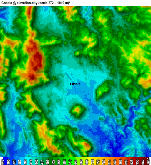
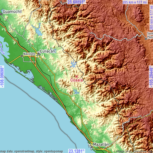
| \ | Map #1 | Map #2 | Topo.Map |
| Scale [m] | 329..972 m | 272..1010 m | × |
| Scale [ft] | 1079..3189 ft | 892..3314 ft | × |
| Average | 473.7 m = 1554 ft | 509.3 m = 1671 ft | × |
| Width | 8.9 km = 5.5 mi | 17.8 km = 11.1 mi | 284.7 km = 176.9 mi |
| Height | 8.9 km = 5.5 mi | 17.8 km = 11.1 mi | 284.8 km = 177 mi |
| ↑Max Latitude | 24.455019° | 24.495016° | 25.68893° |
| Latitude at center | 24.41501° | 24.41501° | 24.41501° |
| ↓Min Latitude | 24.374988° | 24.334954° | 23.1281° |
| ← Min Longitude | -106.734675° | -106.778621° | -108.09698° |
| Longitude center | -106.69073° | -106.69073° | -106.69073° |
| →Max Longitude | -106.646785° | -106.602839° | -105.28448° |
Nearby cities:
Cities around Cosalá sort by population:
• El Rosario elevation 17 m
52.9 km,  250°
250°
• Quila 43 m
53.8 km,  271°
271°
• El Carrizo 50 m
47.5 km,  200°
200°
• Pueblos Unidos 39 m
48.6 km, 253°
• Salado 91 m
48.5 km,  282°
282°
• Oso Viejo 62 m
48.7 km, 267°
• Pueblo Nuevo 20 m
54.3 km,  209°
209°
• Tanques 24 m
51 km,  219°
219°
• Higueras de Abuya 64 m
42.2 km, 245°
• Estación Obispo 38 m
49.4 km, 254°
• Potrerillo del Norote 17 m
52.3 km, 213°
• San Francisco de Tacuichamona 120 m
39.5 km,  261°
261°
Multilingual:
 En español:
Cosalá elevación 389 m.
 En France:
Cosalá élévation 389 m.


Sources and notes:
- [note 1] Map square and city borders are not equal. Map elevation data is calculated only from area inside that square.
- [src 1] Elevation data from geonames database provided with same terms of usage.
- [src 2] The elevation map of Cosalá is generated using elevation data from NASA's 3 arcsec (90m) resolution SRTM data.
- [src 3] Base (background) map © OpenStreetMap contributors tiles are generated by Geofabrik and OpenTopoMap.
Copyright & License:
This Cosalá Elevation Map is licensed under CC BY-SA. You may reuse any part from this page, if you give a proper credit by linking to this URL:
 More info on terms of use page.