Nuevo Ideal elevation
Nuevo Ideal (Durango), Mexico elevation is 1995 meters and Nuevo Ideal elevation in feet is 6545 ft above sea level [src 1]. Nuevo Ideal is a seat of a second-order administrative division (feature code) with elevation that is 681 meters (2234 ft) bigger than average city elevation in Mexico.
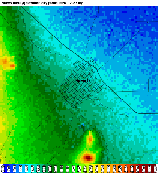
Below is the Elevation map of Nuevo Ideal, which displays elevation range with different colors. Scale of the first map is from 1966 to 2087 m (6450 to 6847 ft) with average elevation of 1997.2 meters (=6552 ft) [note 1]
These maps also provides idea of topography and contour of this city, they are displayed at different zoom levels. More info about maps, scale and edge coordinates you can find below images.
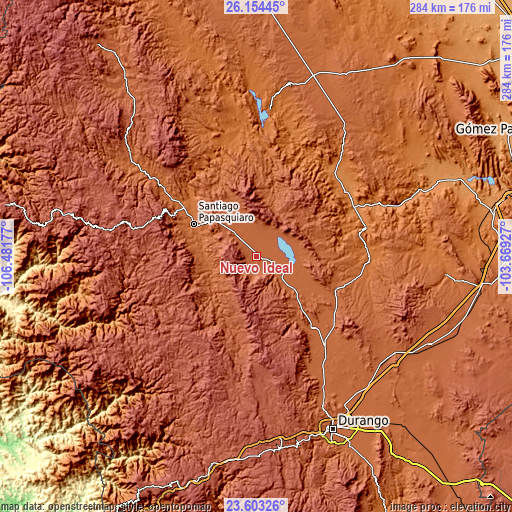
| \ | Map #1 | Map #2 | Topo.Map |
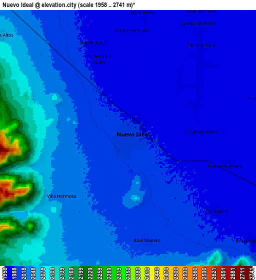
| Scale [m] | 1966..2087 m | 1958..2741 m | × |
| Scale [ft] | 6450..6847 ft | 6424..8993 ft | × |
| Average | 1997.2 m = 6552 ft | 2024.2 m = 6641 ft | × |
| Width | 8.87 km = 5.5 mi | 17.73 km = 11 mi | 283.7 km = 176.3 mi |
| Height | 8.87 km = 5.5 mi | 17.73 km = 11 mi | 283.7 km = 176.3 mi |
| ↑Max Latitude | 24.925299° | 24.965144° | 26.15445° |
| Latitude at center | 24.88544° | 24.88544° | 24.88544° |
| ↓Min Latitude | 24.845569° | 24.805684° | 23.60326° |
| ← Min Longitude | -105.119465° | -105.163411° | -106.48177° |
| Longitude center | -105.07552° | -105.07552° | -105.07552° |
| →Max Longitude | -105.031575° | -104.987629° | -103.66927° |
Nearby cities:
Cities around Nuevo Ideal sort by population:
• Santiago Papasquiaro elevation 1728 m
38.9 km,  296°
296°
• Canatlán 1950 m
50.3 km,  142°
142°
• Rodeo 1348 m
61.4 km,  57°
57°
• San Juan del Rio del Centauro del Norte 1695 m
63.4 km,  100°
100°
• José Guadalupe Aguilera (Santa Lucía) 1929 m
60.6 km, 142°
• Diez de Octubre 1884 m
47.6 km,  111°
111°
• José María Morelos 2031 m
19.5 km,  316°
316°
• San José de Gracia 1935 m
56.7 km, 143°
• Nogales 1907 m
37.2 km,  73°
73°
• Guatimapé 1971 m
17.9 km,  118°
118°
• Esfuerzos Unidos 1981 m
11.1 km,  129°
129°
• Coneto de Comonfort 1964 m
32.5 km, 70°
Multilingual:
 En español:
Patos elevación 1995 m.
 En France:
Nuevo Ideal élévation 1995 m.
 Auf Deutsch:
Nuevo Ideal höhe über dem Meeresspiegel ist 1995 m.

Sources and notes:
- [note 1] Map square and city borders are not equal. Map elevation data is calculated only from area inside that square.
- [src 1] Elevation data from geonames database provided with same terms of usage.
- [src 2] The elevation map of Nuevo Ideal is generated using elevation data from NASA's 3 arcsec (90m) resolution SRTM data.
- [src 3] Base (background) map © OpenStreetMap contributors tiles are generated by Geofabrik and OpenTopoMap.
Copyright & License:
This Nuevo Ideal Elevation Map is licensed under CC BY-SA. You may reuse any part from this page, if you give a proper credit by linking to this URL:
 More info on terms of use page.