Santiago Papasquiaro elevation
Santiago Papasquiaro (Durango), Mexico elevation is 1728 meters and Santiago Papasquiaro elevation in feet is 5669 ft above sea level [src 1]. Santiago Papasquiaro is a populated place (feature code) with elevation that is 414 meters (1358 ft) bigger than average city elevation in Mexico.
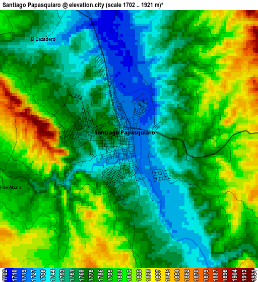
Below is the Elevation map of Santiago Papasquiaro, which displays elevation range with different colors. Scale of the first map is from 1702 to 1921 m (5584 to 6302 ft) with average elevation of 1782.2 meters (=5847 ft) [note 1]
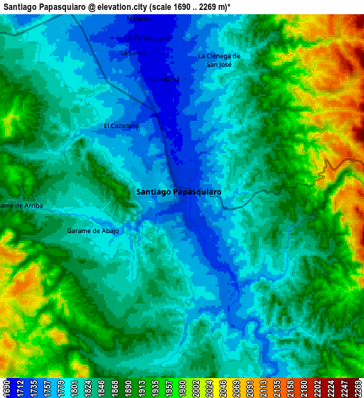
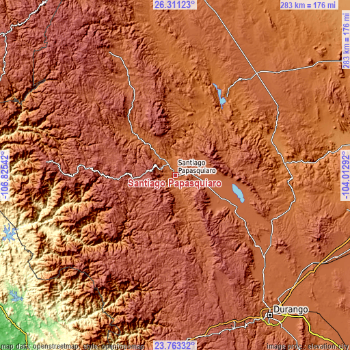
These maps also provides idea of topography and contour of this city, they are displayed at different zoom levels. More info about maps, scale and edge coordinates you can find below images.
| \ | Map #1 | Map #2 | Topo.Map |
| Scale [m] | 1702..1921 m | 1690..2269 m | × |
| Scale [ft] | 5584..6302 ft | 5545..7444 ft | × |
| Average | 1782.2 m = 5847 ft | 1854.2 m = 6083 ft | × |
| Width | 8.85 km = 5.5 mi | 17.71 km = 11 mi | 283.3 km = 176 mi |
| Height | 8.85 km = 5.5 mi | 17.71 km = 11 mi | 283.3 km = 176 mi |
| ↑Max Latitude | 25.083697° | 25.123492° | 26.31123° |
| Latitude at center | 25.04389° | 25.04389° | 25.04389° |
| ↓Min Latitude | 25.00407° | 24.964237° | 23.76332° |
| ← Min Longitude | -105.463115° | -105.507061° | -106.82542° |
| Longitude center | -105.41917° | -105.41917° | -105.41917° |
| →Max Longitude | -105.375225° | -105.331279° | -104.01292° |
Nearby cities:
Cities around Santiago Papasquiaro sort by population:
• Canatlán elevation 1950 m
87 km,  131°
131°
• Nuevo Ideal 1995 m
38.9 km,  116°
116°
• Santa Catarina de Tepehuanes 1809 m
45 km,  316°
316°
• San Miguel de Cruces 2639 m
82.1 km,  211°
211°
• Diez de Octubre 1884 m
86.4 km,  113°
113°
• José María Morelos 2031 m
21.5 km,  99°
99°
• Abasolo 1367 m
82.4 km,  68°
68°
• Nogales 1907 m
70.6 km, 95°
• Guatimapé 1971 m
56.8 km, 117°
• Esfuerzos Unidos 1981 m
49.8 km, 119°
• Coneto de Comonfort 1964 m
65.7 km, 96°
• Otaéz 1711 m
69.6 km,  236°
236°
Multilingual:
 En español:
Santiago Papasquiaro elevación 1728 m.
 En France:
Santiago Papasquiaro élévation 1728 m.
 Auf Deutsch:
Santiago Papasquiaro höhe über dem Meeresspiegel ist 1728 m.
 На русском:
Santiago Papasquiaro высота над уровнем моря 1728 м
Sources and notes:
- [note 1] Map square and city borders are not equal. Map elevation data is calculated only from area inside that square.
- [src 1] Elevation data from geonames database provided with same terms of usage.
- [src 2] The elevation map of Santiago Papasquiaro is generated using elevation data from NASA's 3 arcsec (90m) resolution SRTM data.
- [src 3] Base (background) map © OpenStreetMap contributors tiles are generated by Geofabrik and OpenTopoMap.
Copyright & License:
This Santiago Papasquiaro Elevation Map is licensed under CC BY-SA. You may reuse any part from this page, if you give a proper credit by linking to this URL:
 More info on terms of use page.