Rodeo elevation
Rodeo (Durango), Mexico elevation is 1348 meters and Rodeo elevation in feet is 4423 ft above sea level [src 1]. Rodeo is a seat of a second-order administrative division (feature code) with elevation that is 34 meters (112 ft) bigger than average city elevation in Mexico.
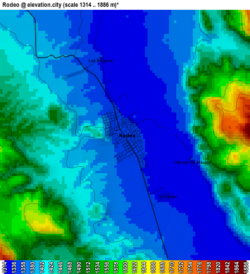
Below is the Elevation map of Rodeo, which displays elevation range with different colors. Scale of the first map is from 1314 to 1886 m (4311 to 6188 ft) with average elevation of 1417.3 meters (=4650 ft) [note 1]
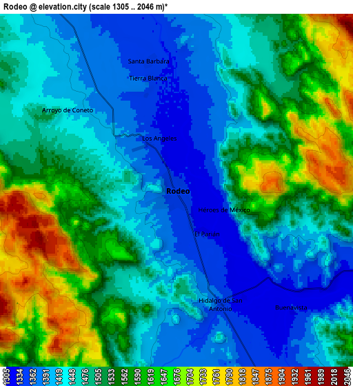
These maps also provides idea of topography and contour of this city, they are displayed at different zoom levels. More info about maps, scale and edge coordinates you can find below images.
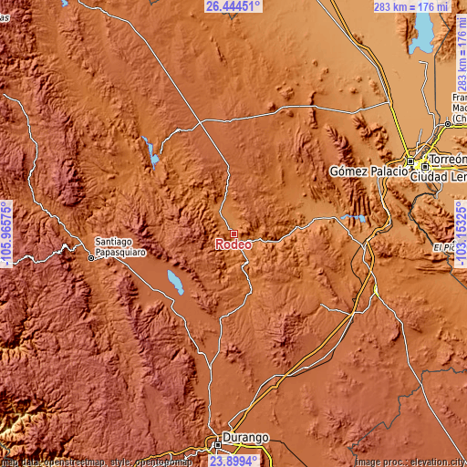
| \ | Map #1 | Map #2 | Topo.Map |
| Scale [m] | 1314..1886 m | 1305..2046 m | × |
| Scale [ft] | 4311..6188 ft | 4281..6713 ft | × |
| Average | 1417.3 m = 4650 ft | 1500.2 m = 4922 ft | × |
| Width | 8.84 km = 5.5 mi | 17.69 km = 11 mi | 283 km = 175.8 mi |
| Height | 8.84 km = 5.5 mi | 17.69 km = 11 mi | 283 km = 175.8 mi |
| ↑Max Latitude | 25.218363° | 25.258114° | 26.44451° |
| Latitude at center | 25.1786° | 25.1786° | 25.1786° |
| ↓Min Latitude | 25.138824° | 25.099034° | 23.8994° |
| ← Min Longitude | -104.603445° | -104.647391° | -105.96575° |
| Longitude center | -104.5595° | -104.5595° | -104.5595° |
| →Max Longitude | -104.515555° | -104.471609° | -103.15325° |
Nearby cities:
Cities around Rodeo sort by population:
• Nazas elevation 1253 m
45.1 km,  83°
83°
• San Juan del Rio del Centauro del Norte 1695 m
45.7 km,  167°
167°
• General Lázaro Cárdenas 1234 m
57.9 km, 77°
• San Luis del Cordero 1495 m
38.6 km,  47°
47°
• Diez de Octubre 1884 m
50.6 km,  188°
188°
• Paso Nacional 1231 m
55.1 km, 80°
• Abasolo 1367 m
17.7 km,  326°
326°
• Nogales 1907 m
27.4 km,  216°
216°
• Esfuerzos Unidos 1981 m
58.8 km,  227°
227°
• Guatimapé 1971 m
55 km, 221°
• Coneto de Comonfort 1964 m
30.6 km, 224°
• San Pedro del Gallo 1654 m
50.5 km,  32°
32°
Multilingual:
 En español:
Rodeo elevación 1348 m.
 En France:
Rodeo élévation 1348 m.


Sources and notes:
- [note 1] Map square and city borders are not equal. Map elevation data is calculated only from area inside that square.
- [src 1] Elevation data from geonames database provided with same terms of usage.
- [src 2] The elevation map of Rodeo is generated using elevation data from NASA's 3 arcsec (90m) resolution SRTM data.
- [src 3] Base (background) map © OpenStreetMap contributors tiles are generated by Geofabrik and OpenTopoMap.
Copyright & License:
This Rodeo Elevation Map is licensed under CC BY-SA. You may reuse any part from this page, if you give a proper credit by linking to this URL:
 More info on terms of use page.