Nazas elevation
Nazas (Durango), Mexico elevation is 1253 meters and Nazas elevation in feet is 4111 ft above sea level [src 1]. Nazas is a seat of a second-order administrative division (feature code) with elevation that is 61 meters (200 ft) smaller than average city elevation in Mexico.
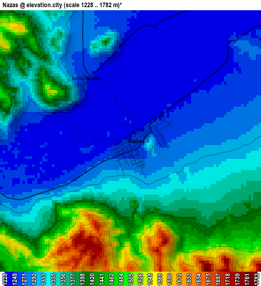
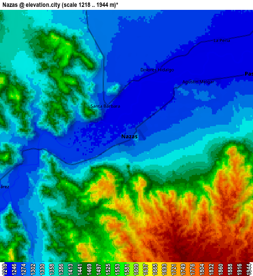
Below is the Elevation map of Nazas, which displays elevation range with different colors. Scale of the first map is from 1228 to 1782 m (4029 to 5846 ft) with average elevation of 1343.6 meters (=4408 ft) [note 1]
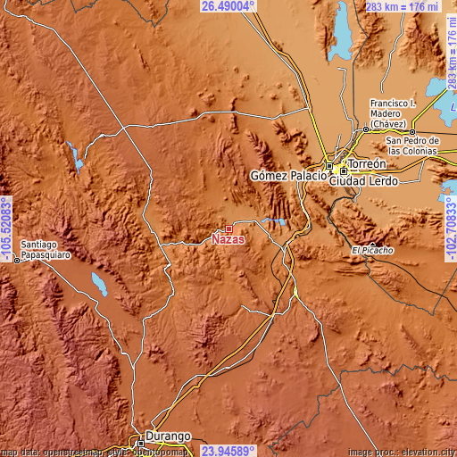
These maps also provides idea of topography and contour of this city, they are displayed at different zoom levels. More info about maps, scale and edge coordinates you can find below images.
| \ | Map #1 | Map #2 | Topo.Map |
| Scale [m] | 1228..1782 m | 1218..1944 m | × |
| Scale [ft] | 4029..5846 ft | 3996..6378 ft | × |
| Average | 1343.6 m = 4408 ft | 1415.6 m = 4644 ft | × |
| Width | 8.84 km = 5.5 mi | 17.68 km = 11 mi | 282.9 km = 175.8 mi |
| Height | 8.84 km = 5.5 mi | 17.68 km = 11 mi | 282.9 km = 175.8 mi |
| ↑Max Latitude | 25.264368° | 25.304104° | 26.49004° |
| Latitude at center | 25.22462° | 25.22462° | 25.22462° |
| ↓Min Latitude | 25.184859° | 25.145084° | 23.94589° |
| ← Min Longitude | -104.158525° | -104.202471° | -105.52083° |
| Longitude center | -104.11458° | -104.11458° | -104.11458° |
| →Max Longitude | -104.070635° | -104.026689° | -102.70833° |
Nearby cities:
Cities around Nazas sort by population:
• Peñón Blanco elevation 1697 m
48.8 km,  169°
169°
• Rodeo 1348 m
45.1 km,  263°
263°
• Velardeña 1375 m
42 km,  115°
115°
• General Lázaro Cárdenas 1234 m
14 km,  56°
56°
• Sapioris 1168 m
47.4 km, 57°
• Pedriceña 1309 m
34.8 km,  109°
109°
• San Jacinto 1172 m
47.4 km,  53°
53°
• San Luis del Cordero 1495 m
26.8 km,  322°
322°
• La Goma 1159 m
51.6 km, 55°
• Pasaje 1586 m
45.2 km,  136°
136°
• Paso Nacional 1231 m
10.5 km,  65°
65°
• San Pedro del Gallo 1654 m
41.8 km,  334°
334°
Multilingual:
 En español:
Nazas elevación 1253 m.
 En France:
Nazas élévation 1253 m.


Sources and notes:
- [note 1] Map square and city borders are not equal. Map elevation data is calculated only from area inside that square.
- [src 1] Elevation data from geonames database provided with same terms of usage.
- [src 2] The elevation map of Nazas is generated using elevation data from NASA's 3 arcsec (90m) resolution SRTM data.
- [src 3] Base (background) map © OpenStreetMap contributors tiles are generated by Geofabrik and OpenTopoMap.
Copyright & License:
This Nazas Elevation Map is licensed under CC BY-SA. You may reuse any part from this page, if you give a proper credit by linking to this URL:
 More info on terms of use page.