Pasaje elevation
Pasaje (Durango, Cuencamé), Mexico elevation is 1586 meters and Pasaje elevation in feet is 5203 ft above sea level [src 1]. Pasaje is a populated place (feature code) with elevation that is 272 meters (892 ft) bigger than average city elevation in Mexico.
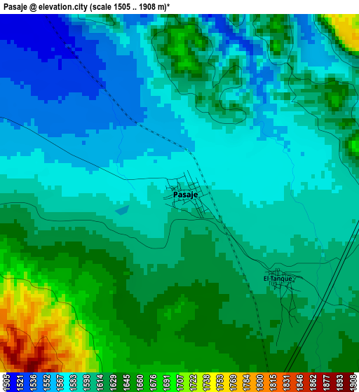
Below is the Elevation map of Pasaje, which displays elevation range with different colors. Scale of the first map is from 1505 to 1908 m (4938 to 6260 ft) with average elevation of 1606.7 meters (=5271 ft) [note 1]
These maps also provides idea of topography and contour of this city, they are displayed at different zoom levels. More info about maps, scale and edge coordinates you can find below images.
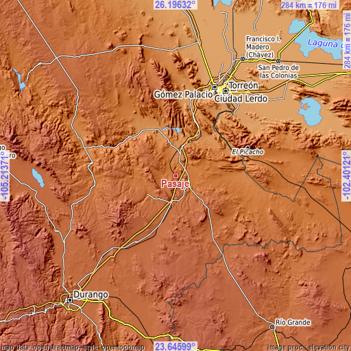
| \ | Map #1 | Topo.Map |
| Scale [m] | 1505..1908 m | × |
| Scale [ft] | 4938..6260 ft | × |
| Average | 1606.7 m = 5271 ft | × |
| Width | 8.86 km = 5.5 mi | 283.6 km = 176.2 mi |
| Height | 8.86 km = 5.5 mi | 283.6 km = 176.2 mi |
| ↑Max Latitude | 24.967595° | 26.19632° |
| Latitude at center | 24.92775° | 24.92775° |
| ↓Min Latitude | 24.887892° | 23.64599° |
| ← Min Longitude | -103.851405° | -105.21371° |
| Longitude center | -103.80746° | -103.80746° |
| →Max Longitude | -103.763515° | -102.40121° |
Nearby cities:
Cities around Pasaje sort by population:
• Cuencamé de Ceniceros elevation 1587 m
12.8 km,  119°
119°
• Peñón Blanco 1697 m
26.7 km,  235°
235°
• Nazas 1253 m
45.2 km,  316°
316°
• Ignacio Allende 1968 m
53.9 km,  200°
200°
• Ignacio Ramírez 2038 m
54.6 km,  211°
211°
• Velardeña 1375 m
16.8 km,  25°
25°
• Emiliano Zapata 2029 m
54.6 km,  188°
188°
• General Lázaro Cárdenas 1234 m
45 km,  334°
334°
• Pedriceña 1309 m
21.3 km,  4°
4°
• Paso Nacional 1231 m
43 km, 330°
• San José de Zaragoza 1227 m
47.9 km,  45°
45°
• Ignacio Zaragoza 1256 m
48.5 km,  61°
61°
Multilingual:
 En español:
Pasaje elevación 1586 m.
 En France:
Pasaje élévation 1586 m.


Sources and notes:
- [note 1] Map square and city borders are not equal. Map elevation data is calculated only from area inside that square.
- [src 1] Elevation data from geonames database provided with same terms of usage.
- [src 2] The elevation map of Pasaje is generated using elevation data from NASA's 3 arcsec (90m) resolution SRTM data.
- [src 3] Base (background) map © OpenStreetMap contributors tiles are generated by Geofabrik and OpenTopoMap.
Copyright & License:
This Pasaje Elevation Map is licensed under CC BY-SA. You may reuse any part from this page, if you give a proper credit by linking to this URL:
 More info on terms of use page.