El Salto elevation
El Salto (Durango, Pueblo Nuevo), Mexico elevation is 2543 meters and El Salto elevation in feet is 8343 ft above sea level [src 1]. El Salto is a seat of a second-order administrative division (feature code) with elevation that is 1229 meters (4032 ft) bigger than average city elevation in Mexico.
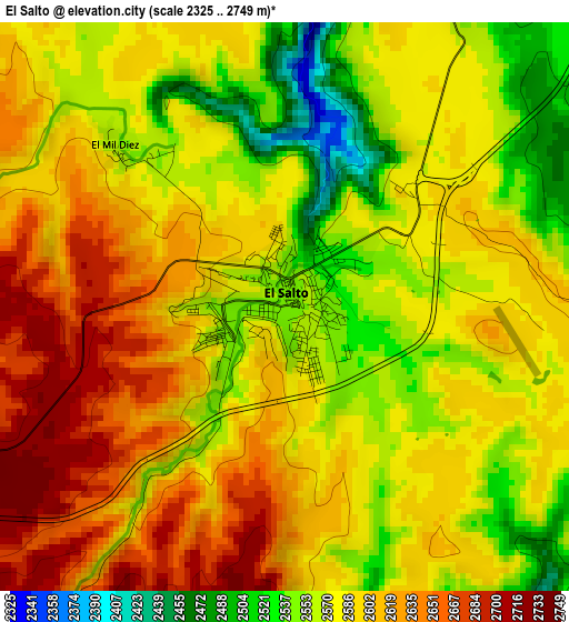
Below is the Elevation map of El Salto, which displays elevation range with different colors. Scale of the first map is from 2325 to 2749 m (7628 to 9019 ft) with average elevation of 2587.8 meters (=8490 ft) [note 1]
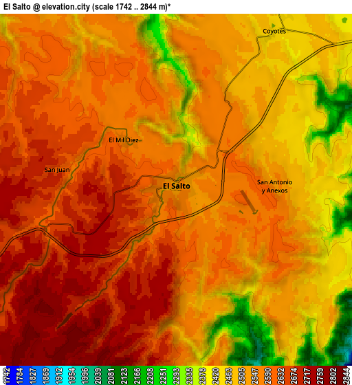
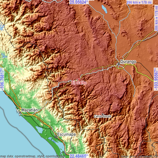
These maps also provides idea of topography and contour of this city, they are displayed at different zoom levels. More info about maps, scale and edge coordinates you can find below images.
| \ | Map #1 | Map #2 | Topo.Map |
| Scale [m] | 2325..2749 m | 1742..2844 m | × |
| Scale [ft] | 7628..9019 ft | 5715..9331 ft | × |
| Average | 2587.8 m = 8490 ft | 2554.8 m = 8382 ft | × |
| Width | 8.94 km = 5.6 mi | 17.89 km = 11.1 mi | 286.2 km = 177.8 mi |
| Height | 8.94 km = 5.6 mi | 17.89 km = 11.1 mi | 286.2 km = 177.8 mi |
| ↑Max Latitude | 23.818019° | 23.858215° | 25.05824° |
| Latitude at center | 23.77781° | 23.77781° | 23.77781° |
| ↓Min Latitude | 23.737589° | 23.697355° | 22.48465° |
| ← Min Longitude | -105.405865° | -105.449811° | -106.76817° |
| Longitude center | -105.36192° | -105.36192° | -105.36192° |
| →Max Longitude | -105.317975° | -105.274029° | -103.95567° |
Nearby cities:
Cities around El Salto sort by population:
• Victoria de Durango elevation 1884 m
76.5 km,  69°
69°
• Pueblo Nuevo 1922 m
44.4 km,  182°
182°
• Tayoltita 536 m
68.2 km,  302°
302°
• El Nayar 1890 m
70.9 km, 72°
• La Ciudad 2570 m
33.7 km,  261°
261°
• Cinco de Mayo 1866 m
87.8 km, 65°
• Llano Grande 2403 m
18.5 km,  59°
59°
• San Miguel de Cruces 2639 m
85.7 km,  325°
325°
• Sebastián Lerdo de Tejada 1884 m
76.3 km,  75°
75°
• San Bernardino de Milpillas Chico 2008 m
48.6 km,  154°
154°
• Banderas del Águila 2402 m
16.6 km,  7°
7°
• Santiago Bayacora 1895 m
77.3 km, 80°
Multilingual:
 En español:
El Salto elevación 2543 m.
 En France:
El Salto élévation 2543 m.
 Auf Deutsch:
El Salto höhe über dem Meeresspiegel ist 2543 m.

Sources and notes:
- [note 1] Map square and city borders are not equal. Map elevation data is calculated only from area inside that square.
- [src 1] Elevation data from geonames database provided with same terms of usage.
- [src 2] The elevation map of El Salto is generated using elevation data from NASA's 3 arcsec (90m) resolution SRTM data.
- [src 3] Base (background) map © OpenStreetMap contributors tiles are generated by Geofabrik and OpenTopoMap.
Copyright & License:
This El Salto Elevation Map is licensed under CC BY-SA. You may reuse any part from this page, if you give a proper credit by linking to this URL:
 More info on terms of use page.