Pueblo Nuevo elevation
Pueblo Nuevo (Durango), Mexico elevation is 1922 meters and Pueblo Nuevo elevation in feet is 6306 ft above sea level [src 1]. Pueblo Nuevo is a populated place (feature code) with elevation that is 608 meters (1995 ft) bigger than average city elevation in Mexico.
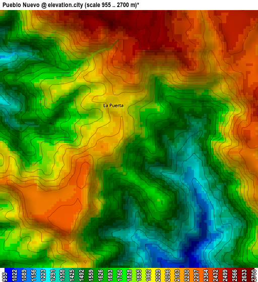
Below is the Elevation map of Pueblo Nuevo, which displays elevation range with different colors. Scale of the first map is from 955 to 2700 m (3133 to 8858 ft) with average elevation of 1874 meters (=6148 ft) [note 1]
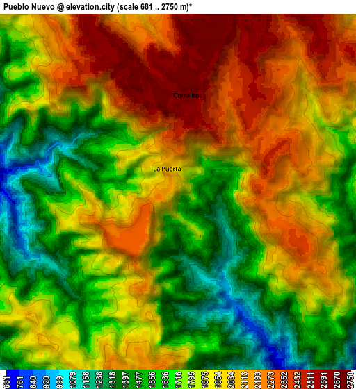
These maps also provides idea of topography and contour of this city, they are displayed at different zoom levels. More info about maps, scale and edge coordinates you can find below images.
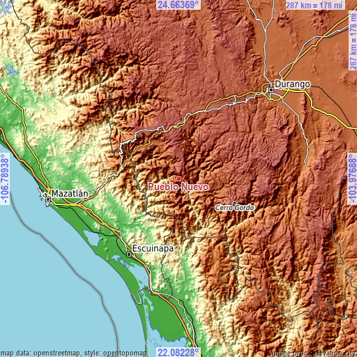
| \ | Map #1 | Map #2 | Topo.Map |
| Scale [m] | 955..2700 m | 681..2750 m | × |
| Scale [ft] | 3133..8858 ft | 2234..9022 ft | × |
| Average | 1874 m = 6148 ft | 1864.3 m = 6116 ft | × |
| Width | 8.97 km = 5.6 mi | 17.94 km = 11.1 mi | 287 km = 178.3 mi |
| Height | 8.97 km = 5.6 mi | 17.94 km = 11.1 mi | 287 km = 178.3 mi |
| ↑Max Latitude | 23.419601° | 23.45992° | 24.66369° |
| Latitude at center | 23.37927° | 23.37927° | 23.37927° |
| ↓Min Latitude | 23.338927° | 23.298571° | 22.08228° |
| ← Min Longitude | -105.427075° | -105.471021° | -106.78938° |
| Longitude center | -105.38313° | -105.38313° | -105.38313° |
| →Max Longitude | -105.339185° | -105.295239° | -103.97688° |
Nearby cities:
Cities around Pueblo Nuevo sort by population:
• Escuinapa elevation 25 m
72.9 km,  213°
213°
• El Salto 2543 m
44.4 km,  2°
2°
• El Rosario 34 m
64.8 km,  228°
228°
• Concordia 115 m
70.3 km,  261°
261°
• La Ciudad 2570 m
50 km,  321°
321°
• Llano Grande 2403 m
56.8 km,  18°
18°
• Cacalotán 39 m
58.3 km, 233°
• Mesillas 138 m
69.5 km, 257°
• San Bernardino de Milpillas Chico 2008 m
23.5 km,  88°
88°
• Banderas del Águila 2402 m
60.9 km, 4°
• Tecualilla 14 m
74.2 km,  203°
203°
• El Huajote 55 m
74.4 km,  248°
248°
Multilingual:
 En español:
Pueblo de Caña elevación 1922 m.
 En France:
Pueblo Nuevo élévation 1922 m.
 Auf Deutsch:
Pueblo Nuevo höhe über dem Meeresspiegel ist 1922 m.

Sources and notes:
- [note 1] Map square and city borders are not equal. Map elevation data is calculated only from area inside that square.
- [src 1] Elevation data from geonames database provided with same terms of usage.
- [src 2] The elevation map of Pueblo Nuevo is generated using elevation data from NASA's 3 arcsec (90m) resolution SRTM data.
- [src 3] Base (background) map © OpenStreetMap contributors tiles are generated by Geofabrik and OpenTopoMap.
Copyright & License:
This Pueblo Nuevo Elevation Map is licensed under CC BY-SA. You may reuse any part from this page, if you give a proper credit by linking to this URL:
 More info on terms of use page.