Santiago Bayacora elevation
Santiago Bayacora (Durango), Mexico elevation is 1895 meters and Santiago Bayacora elevation in feet is 6217 ft above sea level [src 1]. Santiago Bayacora is a populated place (feature code) with elevation that is 581 meters (1906 ft) bigger than average city elevation in Mexico.
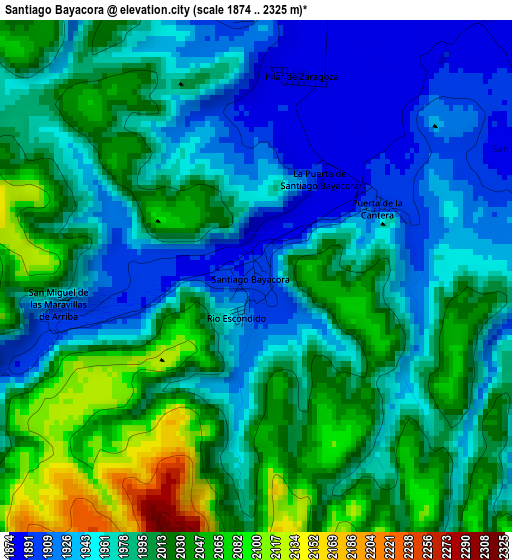
Below is the Elevation map of Santiago Bayacora, which displays elevation range with different colors. Scale of the first map is from 1874 to 2325 m (6148 to 7628 ft) with average elevation of 1987 meters (=6519 ft) [note 1]
These maps also provides idea of topography and contour of this city, they are displayed at different zoom levels. More info about maps, scale and edge coordinates you can find below images.
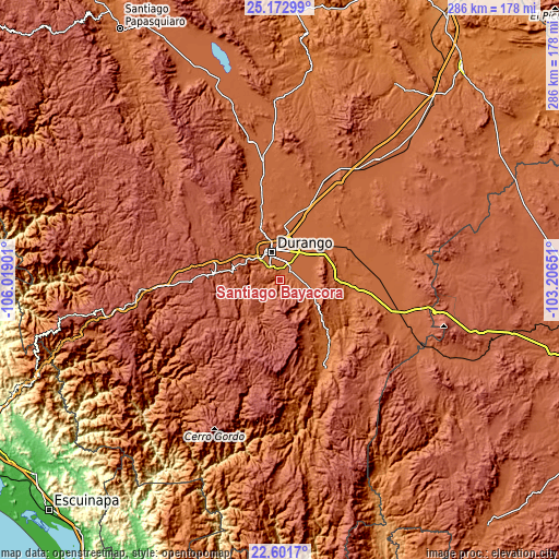
| \ | Map #1 | Topo.Map |
| Scale [m] | 1874..2325 m | × |
| Scale [ft] | 6148..7628 ft | × |
| Average | 1987 m = 6519 ft | × |
| Width | 8.93 km = 5.5 mi | 285.9 km = 177.6 mi |
| Height | 8.93 km = 5.5 mi | 285.9 km = 177.6 mi |
| ↑Max Latitude | 23.933903° | 25.17299° |
| Latitude at center | 23.89373° | 23.89373° |
| ↓Min Latitude | 23.853545° | 22.6017° |
| ← Min Longitude | -104.656705° | -106.01901° |
| Longitude center | -104.61276° | -104.61276° |
| →Max Longitude | -104.568815° | -103.20651° |
Nearby cities:
Cities around Santiago Bayacora sort by population:
• Victoria de Durango elevation 1884 m
14.8 km,  342°
342°
• Nombre de Dios 1731 m
37.5 km,  97°
97°
• El Nayar 1890 m
11.5 km,  313°
313°
• Cinco de Mayo 1866 m
23.5 km,  9°
9°
• José María Pino Suárez 1901 m
12.5 km, 98°
• Hidalgo 1869 m
29.6 km, 5°
• San Francisco del Mezquital 1412 m
51.6 km,  154°
154°
• Sebastián Lerdo de Tejada 1884 m
7.2 km, 340°
• Villa Montemorelos 1865 m
17.3 km,  51°
51°
• José Refugio Salcido 1871 m
12.4 km, 50°
• Cinco de Febrero 1861 m
23.1 km,  28°
28°
• El Arenal 1860 m
26.3 km,  43°
43°
Multilingual:
 En español:
Santiago Bayacora elevación 1895 m.
 En France:
Santiago Bayacora élévation 1895 m.
 Auf Deutsch:
Santiago Bayacora höhe über dem Meeresspiegel ist 1895 m.
 На русском:
Santiago Bayacora высота над уровнем моря 1895 м
Sources and notes:
- [note 1] Map square and city borders are not equal. Map elevation data is calculated only from area inside that square.
- [src 1] Elevation data from geonames database provided with same terms of usage.
- [src 2] The elevation map of Santiago Bayacora is generated using elevation data from NASA's 3 arcsec (90m) resolution SRTM data.
- [src 3] Base (background) map © OpenStreetMap contributors tiles are generated by Geofabrik and OpenTopoMap.
Copyright & License:
This Santiago Bayacora Elevation Map is licensed under CC BY-SA. You may reuse any part from this page, if you give a proper credit by linking to this URL:
 More info on terms of use page.