Karlsdorf-Neuthard elevation
Karlsdorf-Neuthard (Baden-Württemberg, Karlsruhe Region), Germany elevation is 110 meters and Karlsdorf-Neuthard elevation in feet is 361 ft above sea level [src 1]. Karlsdorf-Neuthard is a seat of a fourth-order administrative division (feature code) with elevation that is 148 meters (486 ft) smaller than average city elevation in Germany.
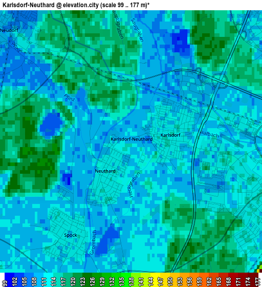
Below is the Elevation map of Karlsdorf-Neuthard, which displays elevation range with different colors. Scale of the first map is from 99 to 177 m (325 to 581 ft) with average elevation of 112.6 meters (=369 ft) [note 1]
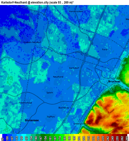
These maps also provides idea of topography and contour of this city, they are displayed at different zoom levels. More info about maps, scale and edge coordinates you can find below images.
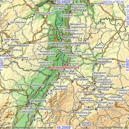
| \ | Map #1 | Map #2 | Topo.Map |
| Scale [m] | 99..177 m | 93..269 m | × |
| Scale [ft] | 325..581 ft | 305..883 ft | × |
| Average | 112.6 m = 369 ft | 123 m = 404 ft | × |
| Width | 6.39 km = 4 mi | 12.79 km = 7.9 mi | 204.6 km = 127.1 mi |
| Height | 6.39 km = 4 mi | 12.79 km = 7.9 mi | 204.6 km = 127.1 mi |
| ↑Max Latitude | 49.163464° | 49.192192° | 50.04628° |
| Latitude at center | 49.13472° | 49.13472° | 49.13472° |
| ↓Min Latitude | 49.105959° | 49.077181° | 48.20608° |
| ← Min Longitude | 8.486335° | 8.442389° | 7.12403° |
| Longitude center | 8.53028° | 8.53028° | 8.53028° |
| →Max Longitude | 8.574225° | 8.618171° | 9.93653° |
Nearby cities:
Cities around Karlsdorf-Neuthard sort by population:
• Bruchsal elevation 118 m
5.1 km,  103°
103°
• Eggenstein-Leopoldshafen 110 m
10.8 km,  242°
242°
• Ubstadt-Weiher 129 m
8 km,  66°
66°
• Philippsburg 100 m
11.9 km,  334°
334°
• Graben-Neudorf 109 m
4.5 km,  322°
322°
• Linkenheim-Hochstetten 106 m
8.6 km,  267°
267°
• Weingarten 115 m
8.9 km,  181°
181°
• Forst 112 m
4.5 km,  54°
54°
• Kronau 109 m
12.2 km,  36°
36°
• Jöhlingen 160 m
11.8 km,  164°
164°
• Hambrücken 107 m
6.2 km,  6°
6°
• Gondelsheim 157 m
12.5 km,  132°
132°
Multilingual:
 En español:
Karlsdorf-Neuthard elevación 110 m.
 En France:
Karlsdorf-Neuthard élévation 110 m.
 Auf Deutsch:
Karlsdorf-Neuthard höhe über dem Meeresspiegel ist 110 m.

Sources and notes:
- [note 1] Map square and city borders are not equal. Map elevation data is calculated only from area inside that square.
- [src 1] Elevation data from geonames database provided with same terms of usage.
- [src 2] The elevation map of Karlsdorf-Neuthard is generated using elevation data from NASA's 3 arcsec (90m) resolution SRTM data.
- [src 3] Base (background) map © OpenStreetMap contributors tiles are generated by Geofabrik and OpenTopoMap.
Copyright & License:
This Karlsdorf-Neuthard Elevation Map is licensed under CC BY-SA. You may reuse any part from this page, if you give a proper credit by linking to this URL:
 More info on terms of use page.