Forst elevation
Forst (Baden-Württemberg, Karlsruhe Region), Germany elevation is 112 meters and Forst elevation in feet is 367 ft above sea level [src 1]. Forst is a seat of a fourth-order administrative division (feature code) with elevation that is 146 meters (479 ft) smaller than average city elevation in Germany.
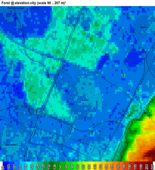
Below is the Elevation map of Forst, which displays elevation range with different colors. Scale of the first map is from 99 to 207 m (325 to 679 ft) with average elevation of 115.2 meters (=378 ft) [note 1]
These maps also provides idea of topography and contour of this city, they are displayed at different zoom levels. More info about maps, scale and edge coordinates you can find below images.

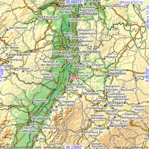
| \ | Map #1 | Map #2 | Topo.Map |
| Scale [m] | 99..207 m | 93..247 m | × |
| Scale [ft] | 325..679 ft | 305..810 ft | × |
| Average | 115.2 m = 378 ft | 126.5 m = 415 ft | × |
| Width | 6.39 km = 4 mi | 12.78 km = 7.9 mi | 204.5 km = 127.1 mi |
| Height | 6.39 km = 4 mi | 12.78 km = 7.9 mi | 204.5 km = 127.1 mi |
| ↑Max Latitude | 49.18734° | 49.216054° | 50.06973° |
| Latitude at center | 49.15861° | 49.15861° | 49.15861° |
| ↓Min Latitude | 49.129863° | 49.101099° | 48.23042° |
| ← Min Longitude | 8.536885° | 8.492939° | 7.17458° |
| Longitude center | 8.58083° | 8.58083° | 8.58083° |
| →Max Longitude | 8.624775° | 8.668721° | 9.98708° |
Nearby cities:
Cities around Forst sort by population:
• Bruchsal elevation 118 m
4 km,  161°
161°
• Waghäusel 106 m
11.3 km,  333°
333°
• Kraichtal 218 m
11.1 km,  97°
97°
• Östringen 163 m
11.7 km,  54°
54°
• Ubstadt-Weiher 129 m
3.7 km,  82°
82°
• Philippsburg 100 m
11.9 km,  312°
312°
• Sankt Leon-Rot 110 m
12.2 km,  12°
12°
• Graben-Neudorf 109 m
6.5 km,  278°
278°
• Weingarten 115 m
12.2 km,  198°
198°
• Karlsdorf-Neuthard 110 m
4.5 km,  234°
234°
• Kronau 109 m
8 km,  27°
27°
• Hambrücken 107 m
4.6 km,  320°
320°
Multilingual:
 En español:
Forst elevación 112 m.
 En France:
Forst élévation 112 m.


Sources and notes:
- [note 1] Map square and city borders are not equal. Map elevation data is calculated only from area inside that square.
- [src 1] Elevation data from geonames database provided with same terms of usage.
- [src 2] The elevation map of Forst is generated using elevation data from NASA's 3 arcsec (90m) resolution SRTM data.
- [src 3] Base (background) map © OpenStreetMap contributors tiles are generated by Geofabrik and OpenTopoMap.
Copyright & License:
This Forst Elevation Map is licensed under CC BY-SA. You may reuse any part from this page, if you give a proper credit by linking to this URL:
 More info on terms of use page.