Luhua elevation
Luhua (Sichuan), China elevation is 2346 meters and Luhua elevation in feet is 7697 ft above sea level [src 1]. Luhua is a seat of a third-order administrative division (feature code) with elevation that is 1788 meters (5866 ft) bigger than average city elevation in China.
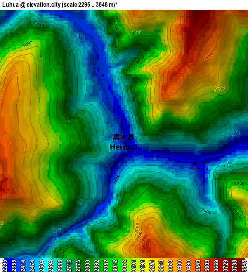
Below is the Elevation map of Luhua, which displays elevation range with different colors. Scale of the first map is from 2295 to 3848 m (7530 to 12625 ft) with average elevation of 2920.7 meters (=9582 ft) [note 1]
These maps also provides idea of topography and contour of this city, they are displayed at different zoom levels. More info about maps, scale and edge coordinates you can find below images.
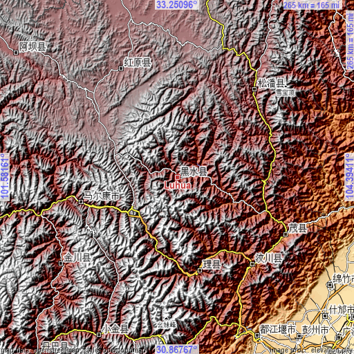
| \ | Map #1 | Topo.Map |
| Scale [m] | 2295..3848 m | × |
| Scale [ft] | 7530..12625 ft | × |
| Average | 2920.7 m = 9582 ft | × |
| Width | 8.28 km = 5.1 mi | 265 km = 164.7 mi |
| Height | 8.28 km = 5.1 mi | 265 km = 164.7 mi |
| ↑Max Latitude | 32.104313° | 33.25096° |
| Latitude at center | 32.06708° | 32.06708° |
| ↓Min Latitude | 32.029832° | 30.86767° |
| ← Min Longitude | 102.943915° | 101.58161° |
| Longitude center | 102.98786° | 102.98786° |
| →Max Longitude | 103.031805° | 104.39411° |
Nearby cities:
Cities around Luhua sort by population:
• Tianpeng elevation 611 m
150.2 km,  143°
143°
• Long’an 873 m
149.8 km,  75°
75°
• Yongchang 942 m
144 km,  108°
108°
• Jiannan 600 m
139.7 km,  125°
125°
• Meixing 2387 m
132.8 km,  206°
206°
• Jinchuan 2199 m
109.7 km,  233°
233°
• Fengyi 1584 m
92.2 km,  117°
117°
• Qiongxi 3493 m
90.8 km,  332°
332°
• Jin’an 2851 m
85.6 km,  41°
41°
• Weizhou 1619 m
85.2 km, 138°
• Barkam 2621 m
74.7 km,  255°
255°
• Zagunao 1826 m
71.3 km,  165°
165°
Multilingual:
 En español:
Luhua elevación 2346 m.
 En France:
Luhua élévation 2346 m.


Sources and notes:
- [note 1] Map square and city borders are not equal. Map elevation data is calculated only from area inside that square.
- [src 1] Elevation data from geonames database provided with same terms of usage.
- [src 2] The elevation map of Luhua is generated using elevation data from NASA's 3 arcsec (90m) resolution SRTM data.
- [src 3] Base (background) map © OpenStreetMap contributors tiles are generated by Geofabrik and OpenTopoMap.
Copyright & License:
This Luhua Elevation Map is licensed under CC BY-SA. You may reuse any part from this page, if you give a proper credit by linking to this URL:
 More info on terms of use page.