Meixing elevation
Meixing (Sichuan), China elevation is 2387 meters and Meixing elevation in feet is 7831 ft above sea level [src 1]. Meixing is a seat of a third-order administrative division (feature code) with elevation that is 1829 meters (6001 ft) bigger than average city elevation in China.
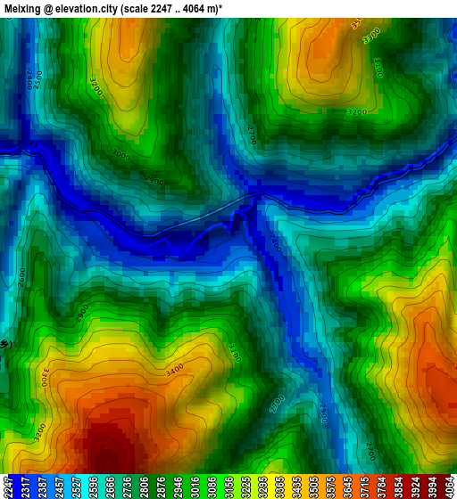
Below is the Elevation map of Meixing, which displays elevation range with different colors. Scale of the first map is from 2247 to 4064 m (7372 to 13333 ft) with average elevation of 2902.4 meters (=9522 ft) [note 1]
These maps also provides idea of topography and contour of this city, they are displayed at different zoom levels. More info about maps, scale and edge coordinates you can find below images.
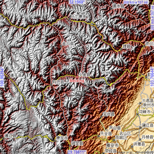
| \ | Map #1 | Topo.Map |
| Scale [m] | 2247..4064 m | × |
| Scale [ft] | 7372..13333 ft | × |
| Average | 2902.4 m = 9522 ft | × |
| Width | 8.38 km = 5.2 mi | 268 km = 166.5 mi |
| Height | 8.38 km = 5.2 mi | 268 km = 166.5 mi |
| ↑Max Latitude | 31.036731° | 32.1968° |
| Latitude at center | 30.99907° | 30.99907° |
| ↓Min Latitude | 30.961394° | 29.78611° |
| ← Min Longitude | 102.316245° | 100.95394° |
| Longitude center | 102.36019° | 102.36019° |
| →Max Longitude | 102.404135° | 103.76644° |
Nearby cities:
Cities around Meixing sort by population:
• Kangding elevation 2826 m
117.4 km,  199°
199°
• Linqiong 511 m
123.6 km,  121°
121°
• Luhua 2346 m
132.8 km,  26°
26°
• Weizhou 1619 m
128.7 km,  64°
64°
• Yucheng 591 m
128.3 km,  151°
151°
• Luqiao 1414 m
119.2 km,  185°
185°
• Xianshui 3243 m
117.5 km,  269°
269°
• Barkam 2621 m
101.1 km,  352°
352°
• Zagunao 1826 m
92.2 km, 57°
• Muping 1016 m
82.2 km, 148°
• Jinchuan 2199 m
60.2 km,  331°
331°
• Zhanggu 2425 m
47.3 km,  252°
252°
Multilingual:
 En español:
Meixing elevación 2387 m.
 En France:
Meixing élévation 2387 m.
 Auf Deutsch:
Meixing höhe über dem Meeresspiegel ist 2387 m.

Sources and notes:
- [note 1] Map square and city borders are not equal. Map elevation data is calculated only from area inside that square.
- [src 1] Elevation data from geonames database provided with same terms of usage.
- [src 2] The elevation map of Meixing is generated using elevation data from NASA's 3 arcsec (90m) resolution SRTM data.
- [src 3] Base (background) map © OpenStreetMap contributors tiles are generated by Geofabrik and OpenTopoMap.
Copyright & License:
This Meixing Elevation Map is licensed under CC BY-SA. You may reuse any part from this page, if you give a proper credit by linking to this URL:
 More info on terms of use page.